Briceville is a quiet town in the northern sector of Anderson County with a total population well under 1,000. “It’s a community of families. You can’t go 2 feet toward the next house without seeing someone that’s kin to you,” says Library Assistant and Briceville native Brandy Goans. The Briceville Public Library is one of the few buildings in the town that is not residential, alongside a US Post Office, an elementary school, some churches and a fire department. Because of the Cold Creek War in the 1800s and the early 20th century mine explosion on Cross Mountain, almost all outsider traffic comes from history buffs and paranormal enthusiasts looking to dig deeper into the chronicles of the area. Homebuyers are drawn to Briceville’s small-town charm and quiet nature, as shopping and dining is done in surrounding areas, such as Clinton and Rocky Top. The Cumberland Mountains also envelop the town, providing many hiking trails and ample green space for other outdoor activities. Residents have traditionally come to Briceville for the mining, and many have stayed for the mountainous views and small-town atmosphere.
Ranch styles dominate Briceville architecture
The most popular architecture in Briceville is ranch-style, with a few colonial and traditional homes sprinkled into the mix. Properties often sell between $100,000 and $200,000, and open lots continue to pop up in the market, often starting around $20,000. Homebuyers can find spacious ranch styles and country cottages in Briceville for the price of one-bedroom condos in Knoxville. The town is set up with clusters of homes separated by empty streets and open land. Some homes are more secluded, offering larger square footage, but many are relatively close together. The area is very car dependent, and sidewalks are rare. Nonetheless, locals can get exercise outdoors by visiting designated walking trails and parks.
Colonial revival in Briceville, TN
Neighborhood homes in Briceville, TN
Homes on Briceville Highway
1/3
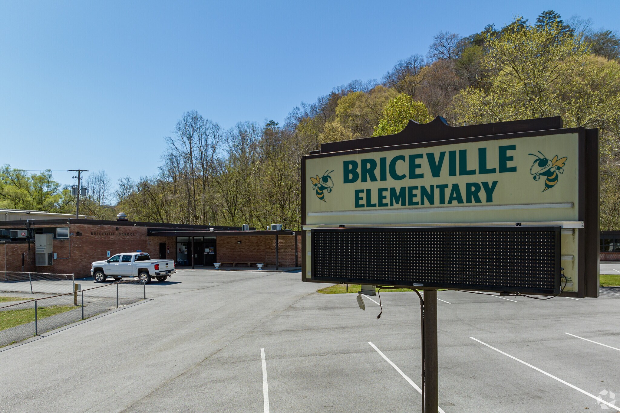
Briceville Elementary School
Briceville students commute to the Home of the Mavs
Primary school students can attend Briceville Elementary, which rates a B on Niche. For higher divisions, children can commute about 5 miles to Rocky Top for Lake City Middle School and about 12 miles to Clinton for Anderson County High School. Lake City Middle earns a B-minus and offers music, art and technology focused programs to incorporate holistic learning into the curriculum. Anderson County High scores a B grade and is the “Home of the Mavs,” and locals from around the area come see the varsity football team play.
Briceville and Rocky Top outdoor opportunities
Briceville is surrounded by mountainous terrain, and residents can hike the Andys Ridge Trails or visit Browns Flats for four-wheeling or riding motorcycles. Rocky Top also features the Norris Dam State Park about 10 miles away. This park is a popular attraction among Briceville locals and features trails, fishing access, campgrounds, rental cabins and a marina.
Aerial view towards Vowell Mountain and Briceville
Middle Creek in Briceville, TN
Gravel road across Middle Creek in Briceville, TN
1/3
Shopping and dining in Rocky Top and Clinton
Briceville residents often head to surrounding towns for groceries and essentials. The Food City, about 14 miles south and Walmart Supercenter about 12 miles east are popular shopping spots in Clinton. Rocky Top, about 5 miles northeast, has fast and casual dining options along with Fox’s Diner, which according to Goans, is “the popular local spot.”
Briceville’s background and eerie events
Briceville’s rich history has engendered a consensus that the area is haunted by fallen soldiers and miners. The Rocky Top Adventure company hosts Paranormal Adventure Tours, and volunteer firefighters lead daring visitors through the Haunted Forest trail. The most popular haunted landmark in Briceville is the Drummond Bridge, which is supposedly haunted by soldier Dick Drummond, who died on the bridge and allegedly now lurks around the area. “People come from all over to see that bridge,” Goans says. “Either they come for the bridge or the Briceville Community Church on the hill, erected in the 1800s by the Welsh.” Paranormal enthusiasts can brave the haunted areas while others can visit one of the oldest standing structures in Anderson County.
Briceville and Knoxville connected via I-75
Tennessee State Route 116 runs through Briceville, providing access to Rocky Top and other surrounding areas. The neighborhood is 30 miles outside of Knoxville via Interstate 75. Briceville does not have public transportation, and the largest airport nearby is McGhee Tyson Airport, about 40 miles south in Alcoa.
GreatSchools:
The GreatSchools Rating helps parents compare schools within a state based on a variety of school quality indicators and provides a helpful picture of how effectively each school serves all of its students. Ratings are on a scale of 1 (below average) to 10 (above average) and can include test scores, college readiness, academic progress, advanced courses, equity, discipline and attendance data. We also advise parents to visit schools, consider other information on school performance and programs, and consider family needs as part of the school selection process.
View GreatSchools Rating Methodology
Sound Score® measures the noise level of any address. Transit Score® measures access to public transit. Bike Score® measures the bikeability of any address.
Disclaimer: Certain information contained herein is derived from information provided by parties other than Homes.com. Our sources include: Accuweather, Public Records and Neustar. All information provided is deemed reliable, but is not guaranteed to be accurate and should be independently verified.