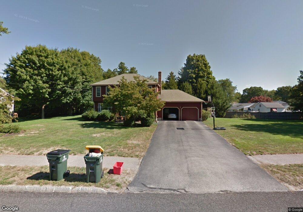
1 Longfellow Dr Franklin, MA 02038
Estimated Value: $763,000 - $882,000
4
Beds
3
Baths
1,976
Sq Ft
$408/Sq Ft
Est. Value
About This Home
This home is located at 1 Longfellow Dr, Franklin, MA 02038 and is currently estimated at $806,949, approximately $408 per square foot. 1 Longfellow Dr is a home located in Norfolk County with nearby schools including Helen Keller Elementary School, Annie Sullivan Middle School, and Franklin High School.
Ownership History
Date
Name
Owned For
Owner Type
Purchase Details
Closed on
Mar 26, 1999
Sold by
Keeler Richard D and Keeler Joann C
Bought by
Quaile Michael T and Quaile Maureen S
Current Estimated Value
Home Financials for this Owner
Home Financials are based on the most recent Mortgage that was taken out on this home.
Original Mortgage
$198,000
Outstanding Balance
$49,054
Interest Rate
6.78%
Mortgage Type
Purchase Money Mortgage
Estimated Equity
$757,895
Create a Home Valuation Report for This Property
The Home Valuation Report is an in-depth analysis detailing your home's value as well as a comparison with similar homes in the area
Purchase History
| Date | Buyer | Sale Price | Title Company |
|---|---|---|---|
| Quaile Michael T | $248,000 | -- |
Source: Public Records
Mortgage History
| Date | Status | Borrower | Loan Amount |
|---|---|---|---|
| Open | Quaile Michael T | $198,000 | |
| Closed | Quaile Michael T | $155,000 | |
| Previous Owner | Quaile Michael T | $103,000 | |
| Previous Owner | Quaile Michael T | $15,000 |
Source: Public Records
Tax History
| Year | Tax Paid | Tax Assessment Tax Assessment Total Assessment is a certain percentage of the fair market value that is determined by local assessors to be the total taxable value of land and additions on the property. | Land | Improvement |
|---|---|---|---|---|
| 2025 | $8,029 | $691,000 | $328,000 | $363,000 |
| 2024 | $7,992 | $677,900 | $328,000 | $349,900 |
| 2023 | $7,713 | $613,100 | $279,600 | $333,500 |
| 2022 | $7,250 | $516,000 | $220,100 | $295,900 |
| 2021 | $7,126 | $486,400 | $247,200 | $239,200 |
| 2020 | $6,749 | $465,100 | $237,000 | $228,100 |
| 2019 | $6,669 | $454,900 | $226,900 | $228,000 |
| 2018 | $6,222 | $424,700 | $218,800 | $205,900 |
| 2017 | $5,956 | $408,500 | $202,600 | $205,900 |
| 2016 | $5,989 | $413,000 | $217,500 | $195,500 |
| 2015 | $5,967 | $402,100 | $206,600 | $195,500 |
| 2014 | $5,443 | $376,700 | $181,200 | $195,500 |
Source: Public Records
Map
Nearby Homes
- 30 Longobardi Dr Unit 30
- 3 Oak View Terrace Unit 3
- 75 Jordan Rd
- 62 Uncas Ave
- 64 Uncas Ave
- 90 E Central St Unit 103
- 90 E Central St Unit 106
- 90 E Central St Unit 304
- 90 E Central St Unit 202
- 90 E Central St Unit 105
- 90 E Central St Unit 301
- 66 Uncas Ave
- 68 Uncas Ave
- 76 Uncas Ave
- 80 Uncas Ave
- 82 Uncas Ave
- 82 Uncas Ave Unit 1
- 17 Longhill Rd
- 99 Summer St
- 88 Crescent St
- 267 Chestnut St
- 1 L#1-A Meetinghouse Ln
- 3 Longfellow Dr
- 251 Chestnut St
- 251 Chestnut St Unit 1
- 251 Chestnut St
- 251 Chestnut St
- 4 Longfellow Dr
- 268 Chestnut St
- 264 Chestnut St
- 309 Chestnut St
- 5 Longfellow Dr
- 278 Chestnut St
- 241 Chestnut St
- 260 Chestnut St
- 8 Longfellow Dr
- 300 Chestnut St
- 235 Chestnut St
- 311 Chestnut St
- 7 Longfellow Dr
Your Personal Tour Guide
Ask me questions while you tour the home.