


10 Maple St Plainfield, MA 01070
Estimated payment $2,895/month
Highlights
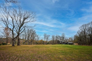
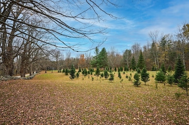
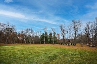
- 3.75 Acre Lot
- Fireplace in Primary Bedroom
- Wooded Lot
- Colonial Architecture
- Deck
- Wood Flooring
About This Home
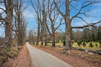
Charming c.1825 Colonial-style home perfectly situated on a quiet country lane lined with majestic old maple trees, offering the quintessential New England homestead setting. This picturesque property rests on 3.75 mostly open acres, idea for gardening and animals or to continue the “Cut Your Own” Christmas Tree family tradition. The lovingly maintained home, updated over the years, offers a warm and comfortable living environment featuring four decorative fireplaces, nice woodwork and beautiful wood floors. The spacious eat-in kitchen includes a Garland gas cooking range, ample cabinetry, and a pellet stove for added warmth. The first floor also offers a living room, dining room, full bath, laundry, and an entry area currently used as an office. Upstairs, there are three bedrooms, full bath, and a walk-up attic. Relax on cozy back porch or deck that overlooks the backyard. Attached is a large workshop ideal for hobbyist and1 car garage with storage. Welcome home to country living!
Home Details
Home Type
- Single Family
Est. Annual Taxes
- $3,927
Year Built
- Built in 1825
Lot Details
- 3.75 Acre Lot
- Level Lot
- Cleared Lot
- Wooded Lot
- Garden
- Property is zoned res/agr
Parking
- 1 Car Attached Garage
- 4 Open Parking Spaces
- Parking Storage or Cabinetry
- Workshop in Garage
Home Design
- Colonial Architecture
- Post and Beam
- Antique Architecture
- Stone Foundation
- Frame Construction
- Shingle Roof
Interior Spaces
- 2,058 Sq Ft Home
- Living Room with Fireplace
- Dining Room with Fireplace
- 4 Fireplaces
- Home Office
- Attic
Kitchen
- Range
- Dishwasher
Flooring
- Wood
- Wall to Wall Carpet
- Ceramic Tile
Bedrooms and Bathrooms
- 3 Bedrooms
- Fireplace in Primary Bedroom
- Primary bedroom located on second floor
- Cedar Closet
- 2 Full Bathrooms
Laundry
- Laundry on main level
- Dryer
- Washer
Basement
- Basement Fills Entire Space Under The House
- Crawl Space
Outdoor Features
- Deck
- Outdoor Storage
- Porch
Schools
- Sanderson Academy Elementary School
- Mtrhs Or HRHS Middle School
- Mtrhs Or HRHS High School
Utilities
- No Cooling
- Forced Air Heating System
- Heating System Uses Oil
- Pellet Stove burns compressed wood to generate heat
- Private Water Source
- Electric Water Heater
- Private Sewer
- High Speed Internet
Listing and Financial Details
- Tax Lot 9
- Assessor Parcel Number 3965395
Community Details
Overview
- No Home Owners Association
- Near Conservation Area
Recreation
- Jogging Path
Map
Home Values in the Area
Average Home Value in this Area
Tax History
| Year | Tax Paid | Tax Assessment Tax Assessment Total Assessment is a certain percentage of the fair market value that is determined by local assessors to be the total taxable value of land and additions on the property. | Land | Improvement |
|---|---|---|---|---|
| 2025 | $3,927 | $212,500 | $40,300 | $172,200 |
| 2024 | $3,712 | $173,300 | $40,000 | $133,300 |
| 2023 | $3,591 | $173,300 | $40,000 | $133,300 |
| 2022 | $3,457 | $173,300 | $40,000 | $133,300 |
| 2021 | $3,302 | $171,600 | $38,700 | $132,900 |
| 2020 | $3,465 | $172,200 | $38,200 | $134,000 |
| 2019 | $3,230 | $166,300 | $38,100 | $128,200 |
| 2018 | $3,167 | $166,000 | $35,300 | $130,700 |
| 2017 | $3,400 | $174,700 | $35,300 | $139,400 |
| 2016 | $3,312 | $175,600 | $33,800 | $141,800 |
| 2015 | $3,094 | $173,500 | $39,100 | $134,400 |
| 2014 | $3,059 | $171,100 | $38,300 | $132,800 |
Property History
| Date | Event | Price | List to Sale | Price per Sq Ft |
|---|---|---|---|---|
| 02/15/2026 02/15/26 | Pending | -- | -- | -- |
| 11/05/2025 11/05/25 | For Sale | $499,000 | -- | $242 / Sq Ft |
Purchase History
| Date | Type | Sale Price | Title Company |
|---|---|---|---|
| Quit Claim Deed | -- | None Available | |
| Quit Claim Deed | -- | None Available |
Source: MLS Property Information Network (MLS PIN)
MLS Number: 73451394
APN: PLAI-000320-000000-000090
Disclaimer: Certain information contained herein is derived from information provided by parties other than Homes.com. All information provided is deemed reliable, but is not guaranteed to be accurate and should be independently verified.
![]() The property listing data and information, or the Images, set forth herein were provided to MLS Property Information Network, Inc. from third party sources, including sellers, lessors and public records, and were compiled by MLS Property Information Network, Inc. The property listing data and information, and the Images, are for the personal, non-commercial use of consumers having a good faith interest in purchasing or leasing listed properties of the type displayed to them and may not be used for any purpose other than to identify prospective properties which such consumers may have a good faith interest in purchasing or leasing. MLS Property Information Network, Inc. and its subscribers disclaim any and all representations and warranties as to the accuracy of the property listing data and information, or as to the accuracy of any of the Images, set forth herein.
The property listing data and information, or the Images, set forth herein were provided to MLS Property Information Network, Inc. from third party sources, including sellers, lessors and public records, and were compiled by MLS Property Information Network, Inc. The property listing data and information, and the Images, are for the personal, non-commercial use of consumers having a good faith interest in purchasing or leasing listed properties of the type displayed to them and may not be used for any purpose other than to identify prospective properties which such consumers may have a good faith interest in purchasing or leasing. MLS Property Information Network, Inc. and its subscribers disclaim any and all representations and warranties as to the accuracy of the property listing data and information, or as to the accuracy of any of the Images, set forth herein.
- 296 E Main St
- 13 Jordan Rd
- 39 Hawley St
- 678 W Main St
- 311 Cummington Rd
- 333 Ranney Corner Rd
- 237 Trouble St
- 0 John Ford Rd Unit 73403156
- 54 Porter Hill Rd
- lot 16 Pierce Rd
- lot 18 Pierce Rd
- lot 19 Pierce Rd
- lot 17 Pierce Rd
- 00 Yale Rd
- 0 E Windsor Rd
- 0 Spruce Corner Rd Unit 73244975
- 458 Old North Rd
- 00 Capen Clark Rd
- 504 Loop Rd
- 500 Loop Rd

Ask me questions while you tour the home.