10 Peases Point Rd Edgartown, MA 02539
Edgartown NeighborhoodEstimated payment $17,439/month
Highlights
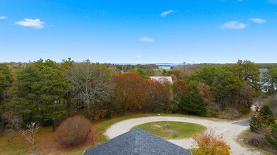
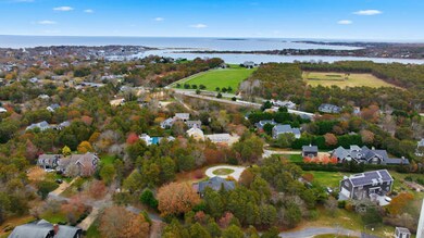
- Property is near a marina
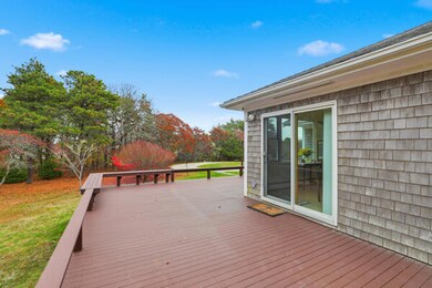
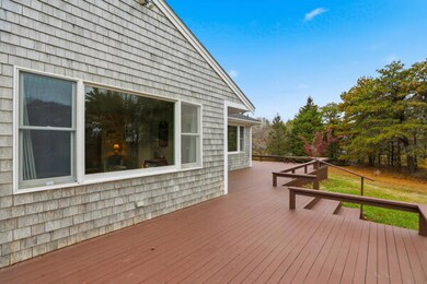
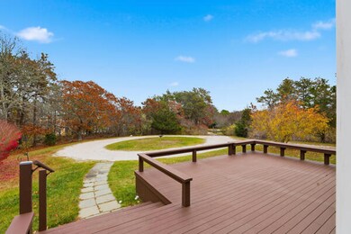
- Deck
- Cooling Available
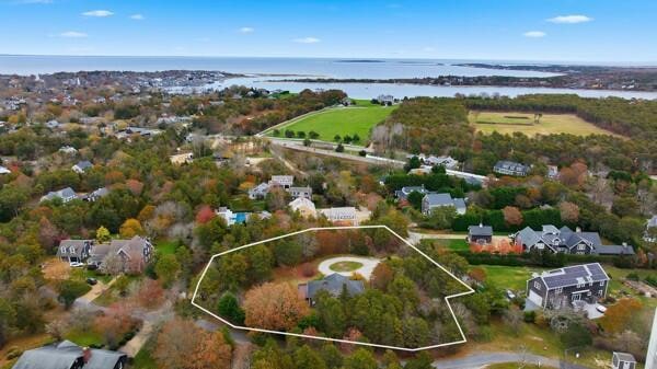
- 1.14 Acre Lot
- No HOA
- Outdoor Shower
About This Home
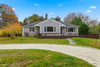
NEWLY LISTED l PRIME 1.14 ACRE PROPERTY IN EDGARTOWN -This conforming R-20 lot offers an exceptional canvas for your estate planning vision. Positioned on an elevated parcel amid a neighborhood of distinguished new homes, the original three-bedroom, two-bath residence provides a foundation from which to create a truly signature property. Ideally situated just minutes from Edgartown Village, with Katama and South Beach only a short distance away, the location blends convenience with coastal appeal. Dual access from Pease's Point Road and Mill Hill enhances the property's versatility. Please note that the listing agent or a representative must be present for all showings.
Home Details
Home Type
- Single Family
Est. Annual Taxes
- $3,294
Year Built
- Built in 1960
Lot Details
- 1.14 Acre Lot
- Property fronts a private road
- Property is zoned R20
Parking
- 1 Car Garage
- Open Parking
Home Design
- Block Foundation
- Asphalt Roof
Interior Spaces
- 1,528 Sq Ft Home
- 1-Story Property
Flooring
- Carpet
- Laminate
Bedrooms and Bathrooms
- 3 Bedrooms
- 2 Full Bathrooms
Basement
- Basement Fills Entire Space Under The House
- Interior Basement Entry
Outdoor Features
- Outdoor Shower
- Property is near a marina
- Deck
Location
- Property is near shops
- Property is near a golf course
Utilities
- Cooling Available
- Heating Available
- Septic Tank
Listing and Financial Details
- Assessor Parcel Number EDGA M:0029 B:0057 L:7
Community Details
Overview
- No Home Owners Association
Recreation
- Bike Trail
Map
Home Values in the Area
Average Home Value in this Area
Tax History
| Year | Tax Paid | Tax Assessment Tax Assessment Total Assessment is a certain percentage of the fair market value that is determined by local assessors to be the total taxable value of land and additions on the property. | Land | Improvement |
|---|---|---|---|---|
| 2025 | $3,294 | $1,243,000 | $610,400 | $632,600 |
| 2024 | $3,086 | $1,210,000 | $610,400 | $599,600 |
| 2023 | $2,791 | $1,107,400 | $631,900 | $475,500 |
| 2022 | $2,815 | $929,100 | $620,700 | $308,400 |
| 2021 | $2,880 | $877,900 | $538,100 | $339,800 |
| 2020 | $2,479 | $740,000 | $494,500 | $245,500 |
| 2019 | $2,807 | $725,400 | $479,900 | $245,500 |
| 2018 | $2,519 | $651,000 | $436,300 | $214,700 |
| 2017 | $2,307 | $649,800 | $465,400 | $184,400 |
| 2016 | $2,134 | $589,500 | $421,800 | $167,700 |
| 2015 | $1,966 | $566,700 | $421,800 | $144,900 |
Property History
| Date | Event | Price | List to Sale | Price per Sq Ft |
|---|---|---|---|---|
| 11/21/2025 11/21/25 | For Sale | $3,250,000 | -- | $2,127 / Sq Ft |
Purchase History
| Date | Type | Sale Price | Title Company |
|---|---|---|---|
| Quit Claim Deed | -- | None Available | |
| Quit Claim Deed | -- | None Available | |
| Quit Claim Deed | -- | None Available | |
| Quit Claim Deed | -- | None Available |
Mortgage History
| Date | Status | Loan Amount | Loan Type |
|---|---|---|---|
| Previous Owner | $350,000 | New Conventional |
Source: Cape Cod & Islands Association of REALTORS®
MLS Number: 22505706
APN: EDGA-000029-000057-000007
Disclaimer: Certain information contained herein is derived from information provided by parties other than Homes.com. All information provided is deemed reliable, but is not guaranteed to be accurate and should be independently verified.
![]() All data relating to real estate for sale on this page comes from the Broker Reciprocity (BR) of the Cape Cod & Islands Multiple Listing Service, Inc. Detailed information about real estate listings held by brokerage firms other than CC&I Assoc. of REALTORS®, Inc. includes the name of the listing company. Neither the listing company nor CC&I Assoc. of REALTORS®, Inc. shall be responsible for any typographical errors, misinformation, misprints and shall be held totally harmless. The Broker providing this data believes it to be correct, but advises interested parties to confirm any item before relying on it in a purchase decision. All properties are subject to prior sale, changes, or withdrawal. Copyright 2025 © Cape Cod & Islands Multiple Listing Service, Inc. All rights reserved.
All data relating to real estate for sale on this page comes from the Broker Reciprocity (BR) of the Cape Cod & Islands Multiple Listing Service, Inc. Detailed information about real estate listings held by brokerage firms other than CC&I Assoc. of REALTORS®, Inc. includes the name of the listing company. Neither the listing company nor CC&I Assoc. of REALTORS®, Inc. shall be responsible for any typographical errors, misinformation, misprints and shall be held totally harmless. The Broker providing this data believes it to be correct, but advises interested parties to confirm any item before relying on it in a purchase decision. All properties are subject to prior sale, changes, or withdrawal. Copyright 2025 © Cape Cod & Islands Multiple Listing Service, Inc. All rights reserved.
- 7 Mill Hill Farms Rd Ed315
- 54 Schoolhouse Road Ed330
- 29 Mercier Way
- 60 Witchwood Lane Ed317
- 12 Cottle Lane Ed341
- 19 Morse St
- 175 Meetinghouse Way Ed321
- 9 Thaxter Lane Ed310
- 17 Edgartown Bay Rd Ed328
- 1 Meetinghouse Village Way Unit 1 ED335
- 15 Price's Way Ed322
- 74 Turkeyland Cove Rd Ed306
- 76 Mattakesett Way Ed313
- 2 Fishermans Knot Rd Ed309 Unit 1
- 20 Katama Bay Rd Ed350
- 39 N Neck Rd
- 97 3rd St N
- 16 Majors Cove Ln
- 2 Nonamessett Rd
- 40 Hidden Cove Rd
