
Seller's Agent in 2025
Ray Robinson
(925) 658-2273
1 in this area
21 Total Sales
Estimated Value: $942,000 - $1,411,776
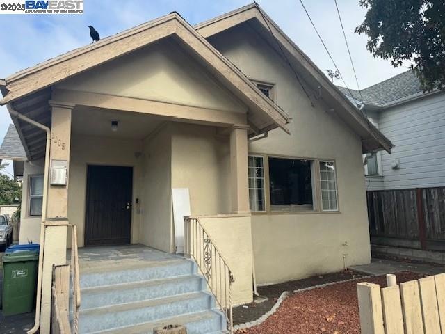
This fixer upper property is situated along the East Bay shoreline. West Berkeley is a vibrant neighborhood spanning several city blocks with quaint homes, modern condos and a growing lifestyle scene. There are a lot of hip shops and restaurants in West Berkeley along Fourth Street. There are also many beautiful parks along the coastline and lots of bungalows in the neighborhood.
| Date | Buyer | Sale Price | Title Company |
|---|---|---|---|
| Ac Bard Ii Llc | $950,000 | Old Republic Title Company | |
| Lois Payne-Carter Separate Property Living Tr | -- | -- | |
| Payne Carter Lois | -- | None Available | |
| Lois Payne-Carter Separate Property Living Tr | -- | -- | |
| Payne John H | -- | None Available | |
| Payne John | -- | -- |
| Date | Status | Borrower | Loan Amount |
|---|---|---|---|
| Open | Ac Bard Ii Llc | $1,275,000 |
| Date | Event | Price | List to Sale | Price per Sq Ft |
|---|---|---|---|---|
| 12/29/2025 12/29/25 | Sold | $950,000 | -17.4% | $535 / Sq Ft |
| 11/23/2025 11/23/25 | Pending | -- | -- | -- |
| 11/10/2025 11/10/25 | Price Changed | $1,150,000 | -13.2% | $648 / Sq Ft |
| 10/27/2025 10/27/25 | For Sale | $1,325,000 | -- | $746 / Sq Ft |
| Year | Tax Paid | Tax Assessment Tax Assessment Total Assessment is a certain percentage of the fair market value that is determined by local assessors to be the total taxable value of land and additions on the property. | Land | Improvement |
|---|---|---|---|---|
| 2025 | $20,192 | $842,428 | $255,993 | $593,435 |
| 2024 | $20,192 | $1,345,520 | $405,756 | $946,764 |
| 2023 | $19,742 | $1,326,000 | $397,800 | $928,200 |
| 2022 | $4,314 | $1,293,000 | $390,000 | $910,000 |
| 2021 | $4,274 | $37,168 | $15,402 | $28,766 |
| 2020 | $3,938 | $43,715 | $15,244 | $28,471 |
| 2019 | $3,644 | $42,858 | $14,945 | $27,913 |
| 2018 | $3,518 | $42,018 | $14,652 | $27,366 |
| 2017 | $3,362 | $41,194 | $14,365 | $26,829 |
| 2016 | $3,125 | $40,386 | $14,083 | $26,303 |
| 2015 | $3,049 | $39,780 | $13,872 | $25,908 |
| 2014 | $2,960 | $39,001 | $13,600 | $25,401 |
Seller's Agent in 2025
Ray Robinson
(925) 658-2273
1 in this area
21 Total Sales
Buyer's Agent in 2025
SHANNON MITCHELL
Compass
(415) 359-3820
4 in this area
18 Total Sales
Source: Bay East Association of REALTORS®
MLS Number: 41115918
APN: 056-1973-014-01
Disclaimer: Certain information contained herein is derived from information provided by parties other than Homes.com. All information provided is deemed reliable, but is not guaranteed to be accurate and should be independently verified.
![]() Bay East ©2026. CCAR ©2026. bridgeMLS ©2026. Information Deemed Reliable But Not Guaranteed. This information is being provided by the Bay East MLS, or CCAR MLS, or bridgeMLS. The listings presented here may or may not be listed by the Broker/Agent operating this website. This information is intended for the personal use of consumers and may not be used for any purpose other than to identify prospective properties consumers may be interested in purchasing.
Bay East ©2026. CCAR ©2026. bridgeMLS ©2026. Information Deemed Reliable But Not Guaranteed. This information is being provided by the Bay East MLS, or CCAR MLS, or bridgeMLS. The listings presented here may or may not be listed by the Broker/Agent operating this website. This information is intended for the personal use of consumers and may not be used for any purpose other than to identify prospective properties consumers may be interested in purchasing.
Ask me questions while you tour the home.