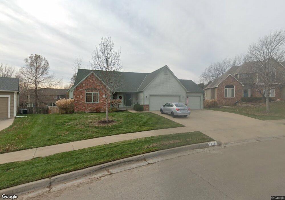
1013 Langston Ct Lawrence, KS 66049
West Lawrence NeighborhoodEstimated Value: $514,729 - $592,000
4
Beds
3
Baths
2,840
Sq Ft
$195/Sq Ft
Est. Value
About This Home
This home is located at 1013 Langston Ct, Lawrence, KS 66049 and is currently estimated at $554,432, approximately $195 per square foot. 1013 Langston Ct is a home located in Douglas County with nearby schools including Langston Hughes Elementary School, Southwest Middle School, and Lawrence Free State High School.
Ownership History
Date
Name
Owned For
Owner Type
Purchase Details
Closed on
Aug 23, 2006
Sold by
Nunley Donald W and Nunley Catherine E
Bought by
Alexander Warren D and Alexander Virgie L
Current Estimated Value
Home Financials for this Owner
Home Financials are based on the most recent Mortgage that was taken out on this home.
Original Mortgage
$240,000
Outstanding Balance
$143,151
Interest Rate
6.64%
Mortgage Type
Purchase Money Mortgage
Estimated Equity
$411,281
Purchase Details
Closed on
Jul 17, 2001
Sold by
Stuart Jimmy L and Stuart Mary Lynn
Bought by
Nunley Donald W and Nunley Catherine E
Home Financials for this Owner
Home Financials are based on the most recent Mortgage that was taken out on this home.
Original Mortgage
$199,430
Interest Rate
7.07%
Mortgage Type
Balloon
Create a Home Valuation Report for This Property
The Home Valuation Report is an in-depth analysis detailing your home's value as well as a comparison with similar homes in the area
Home Values in the Area
Average Home Value in this Area
Purchase History
| Date | Buyer | Sale Price | Title Company |
|---|---|---|---|
| Alexander Warren D | -- | Capital Title Ins Co Lc | |
| Nunley Donald W | -- | Commerce Title |
Source: Public Records
Mortgage History
| Date | Status | Borrower | Loan Amount |
|---|---|---|---|
| Open | Alexander Warren D | $240,000 | |
| Previous Owner | Nunley Donald W | $199,430 |
Source: Public Records
Tax History
| Year | Tax Paid | Tax Assessment Tax Assessment Total Assessment is a certain percentage of the fair market value that is determined by local assessors to be the total taxable value of land and additions on the property. | Land | Improvement |
|---|---|---|---|---|
| 2025 | $7,425 | $59,249 | $9,200 | $50,049 |
| 2024 | $6,953 | $55,534 | $7,475 | $48,059 |
| 2023 | $7,042 | $54,441 | $7,475 | $46,966 |
| 2022 | $6,669 | $51,221 | $7,475 | $43,746 |
| 2021 | $5,713 | $42,642 | $6,334 | $36,308 |
| 2020 | $5,517 | $41,400 | $6,334 | $35,066 |
| 2019 | $4,951 | $37,225 | $6,334 | $30,891 |
| 2018 | $4,955 | $36,984 | $6,334 | $30,650 |
| 2017 | $4,909 | $36,236 | $6,334 | $29,902 |
| 2016 | $4,528 | $34,925 | $5,753 | $29,172 |
| 2015 | $2,250 | $34,707 | $5,753 | $28,954 |
| 2014 | $2,172 | $33,844 | $5,753 | $28,091 |
Source: Public Records
Map
Nearby Homes
- 1033 Stonecreek Dr
- 5204 Foxchase Dr
- 5204 Fox Chase Dr
- 1236 Juniper Ln
- 1202 Little Knife
- 5007 Congressional Way
- 5245 Overland Dr Unit C7
- 5245 Overland Dr Unit B23
- 1315 Research Park Dr
- 904 Moundridge Dr
- 5710 Goff Ct
- 4624 Hearthside Dr
- 4600 Royal Birkdale Ct
- 6309 Serenade Ct
- 1120 Klein Ct
- 1604 Bob White Dr
- 1522 Legend Trail Dr Unit B
- 1549 Legend Trail Dr Unit A
- 1601 Research Park Dr
- 1528 Legend Trail Dr Unit A
- 1009 Langston Ct
- 1017 Langston Ct
- 1112 Stoneridge Dr
- 1116 Stoneridge Dr
- 1104 Stoneridge Dr
- 1005 Langston Ct
- 1021 Langston Ct
- 1012 Langston Ct
- 1016 Branchwood Dr
- 1012 Branchwood Dr
- 1100 Stoneridge Dr
- 1008 Branchwood Dr
- 1016 Langston Ct
- 1001 Langston Ct
- 1113 Stoneridge Dr
- 1004 Branchwood Dr
- 1109 Stoneridge Dr
- 1008 Langston Ct
- 1117 Stoneridge Dr
- 5208 Harvard Rd