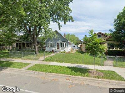
1017 Minnehaha Ave W Saint Paul, MN 55104
Frogtown NeighborhoodEstimated Value: $260,356 - $279,000
3
Beds
2
Baths
1,267
Sq Ft
$212/Sq Ft
Est. Value
About This Home
This home is located at 1017 Minnehaha Ave W, Saint Paul, MN 55104 and is currently estimated at $269,089, approximately $212 per square foot. 1017 Minnehaha Ave W is a home located in Ramsey County with nearby schools including Maxfield Magnet Elementary School, Hidden River Middle School, and Central Senior High School.
Ownership History
Date
Name
Owned For
Owner Type
Purchase Details
Closed on
Jul 8, 2015
Sold by
Brinker Daniel J and Brinker Ashley
Bought by
Seidel Ryan F and Seidel Erica M
Current Estimated Value
Home Financials for this Owner
Home Financials are based on the most recent Mortgage that was taken out on this home.
Original Mortgage
$127,920
Interest Rate
3.83%
Purchase Details
Closed on
Nov 19, 2008
Sold by
Campeau Alvin Raymond and Mcgrew Laurie V
Bought by
Brinker Daniel J
Purchase Details
Closed on
Oct 11, 2001
Sold by
Campeau Alvin R
Bought by
Raschick Daniel J
Create a Home Valuation Report for This Property
The Home Valuation Report is an in-depth analysis detailing your home's value as well as a comparison with similar homes in the area
Home Values in the Area
Average Home Value in this Area
Purchase History
| Date | Buyer | Sale Price | Title Company |
|---|---|---|---|
| Seidel Ryan F | $164,745 | Alliance Title Llc | |
| Brinker Daniel J | $165,000 | -- | |
| Raschick Daniel J | $100,000 | -- |
Source: Public Records
Mortgage History
| Date | Status | Borrower | Loan Amount |
|---|---|---|---|
| Open | Seidel Erica M | $58,600 | |
| Open | Seidel Erica M | $165,000 | |
| Closed | Seidel Erica M | $155,200 | |
| Closed | Seidel Ryan F | $127,920 | |
| Closed | Raschick Daniel J | -- |
Source: Public Records
Tax History Compared to Growth
Tax History
| Year | Tax Paid | Tax Assessment Tax Assessment Total Assessment is a certain percentage of the fair market value that is determined by local assessors to be the total taxable value of land and additions on the property. | Land | Improvement |
|---|---|---|---|---|
| 2023 | $3,348 | $226,400 | $18,000 | $208,400 |
| 2022 | $3,352 | $234,800 | $18,000 | $216,800 |
| 2021 | $3,484 | $219,700 | $20,000 | $199,700 |
| 2020 | $3,194 | $234,900 | $10,700 | $224,200 |
| 2019 | $2,584 | $204,300 | $10,700 | $193,600 |
| 2018 | $2,426 | $168,200 | $10,700 | $157,500 |
| 2017 | $2,150 | $164,100 | $10,700 | $153,400 |
| 2016 | $1,432 | $0 | $0 | $0 |
| 2015 | $1,822 | $103,800 | $10,700 | $93,100 |
| 2014 | -- | $0 | $0 | $0 |
Source: Public Records
Map
Nearby Homes
- 1000 Hubbard Ave
- 1030 Topping St
- 1133 Seminary Ave
- 925 Thomas Ave
- 917 Thomas Ave
- 1171 Seminary Ave
- 839 Englewood Ave
- 857 Lafond Ave
- 1076 Edmund Ave
- 1107 Edmund Ave
- 1107 Edmund Ave W
- 1175 Lafond Ave
- 1202 Van Buren Ave
- 1183 Thomas Ave
- 983 Sherburne Ave
- 945 Sherburne Ave
- 900 Charles Ave
- 785 Pierce Butler Route
- 852 Edmund Ave
- 842 Edmund Ave
- 1017 Minnehaha Ave W
- 1011 1011 Minnehaha Ave W
- 1011 Minnehaha Ave W
- 1023 Minnehaha Ave W
- 1007 Minnehaha Ave W
- 1027 Minnehaha Ave W
- 1005 1005 Minnehaha Ave W
- 1031 Minnehaha Ave W
- 1012 Englewood Ave
- 1020 Englewood Ave
- 1035 Minnehaha Ave W
- 1008 Englewood Ave
- 1024 Englewood Ave
- 1004 Englewood Ave
- 1030 Englewood Ave
- 1018 Minnehaha Ave W
- 1012 Minnehaha Ave W
- 726 Oxford St N
- 999 Minnehaha Ave W
- 1022 Minnehaha Ave W