Estimated Value: $252,000 - $275,977
2
Beds
2
Baths
1,424
Sq Ft
$185/Sq Ft
Est. Value
About This Home
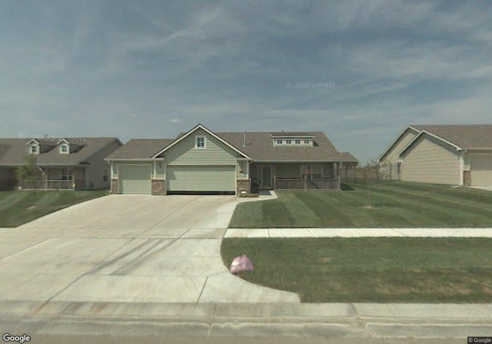
This home is located at 1018 E Stone Path St, Derby, KS 67037 and is currently estimated at $263,989, approximately $185 per square foot. 1018 E Stone Path St is a home located in Sedgwick County with nearby schools including Derby Hills Elementary, Derby High School, and St Mary Parish Catholic School.
Ownership History
Date
Name
Owned For
Owner Type
Purchase Details
Closed on
Jun 20, 2022
Sold by
Childs Rex L
Bought by
Beard Robert A and Beard Pamela J
Current Estimated Value
Home Financials for this Owner
Home Financials are based on the most recent Mortgage that was taken out on this home.
Original Mortgage
$178,000
Outstanding Balance
$168,867
Interest Rate
5.1%
Mortgage Type
New Conventional
Estimated Equity
$95,122
Create a Home Valuation Report for This Property
The Home Valuation Report is an in-depth analysis detailing your home's value as well as a comparison with similar homes in the area
Home Values in the Area
Average Home Value in this Area
Purchase History
| Date | Buyer | Sale Price | Title Company |
|---|---|---|---|
| Beard Robert A | -- | Security 1St Title |
Source: Public Records
Mortgage History
| Date | Status | Borrower | Loan Amount |
|---|---|---|---|
| Open | Beard Robert A | $178,000 |
Source: Public Records
Tax History
| Year | Tax Paid | Tax Assessment Tax Assessment Total Assessment is a certain percentage of the fair market value that is determined by local assessors to be the total taxable value of land and additions on the property. | Land | Improvement |
|---|---|---|---|---|
| 2025 | $3,621 | $27,750 | $7,418 | $20,332 |
| 2024 | $3,621 | $26,945 | $6,061 | $20,884 |
| 2023 | $3,621 | $24,415 | $6,061 | $18,354 |
| 2022 | $2,681 | $21,609 | $5,716 | $15,893 |
| 2021 | $2,531 | $20,195 | $3,416 | $16,779 |
| 2020 | $2,695 | $18,872 | $3,416 | $15,456 |
| 2019 | $2,144 | $18,148 | $3,416 | $14,732 |
| 2018 | $2,483 | $17,446 | $3,347 | $14,099 |
| 2017 | $3,476 | $0 | $0 | $0 |
| 2016 | $3,569 | $0 | $0 | $0 |
| 2015 | $3,530 | $0 | $0 | $0 |
| 2014 | $3,440 | $0 | $0 | $0 |
Source: Public Records
Map
Nearby Homes
- 2801 N Emerson Cir
- 2531 N Rough Creek Rd
- 430 E Wild Plum Rd
- 1085 E Splitwood Way Ct
- 3301 N Emerson St
- 2567 N Button Bush Cir
- 2224 N Rough Creek Rd
- 1219 E Waters Edge St
- 3425 N Laughlin
- 931 E Hickam St
- 501 E Tall Tree Rd
- 1009 E Cross Creek Place
- 1312 E Lookout St
- 1242 E Lookout St
- 2048 N Forest Park St
- LOT 2 Block B
- 226 W Rosewood Ln
- 225 E Ripley Ct
- 1722 N Overlook Dr
- 1427 N Community Dr
- 1024 E Stone Path St
- 1013 E Moss Wood St
- 1019 E Moss Wood St
- 1007 E Moss Wood St
- 1006 E Stone Path St
- 1030 E Stone Path St
- 1019 E Stone Path St
- 1019 Stone Path
- 1025 E Stone Path St
- 1013 E Stone Path St
- 1025 E Moss Wood St
- 1001 E Moss Wood St
- 1031 E Stone Path St
- 1007 E Stone Path St
- 1000 E Stone Path St
- 1001 Stone Path
- 931 E Moss Wood St
- 1001 E Stone Path St
- 942 E Stone Path St
- 1028 E Moss Wood Ct
Your Personal Tour Guide
Ask me questions while you tour the home.