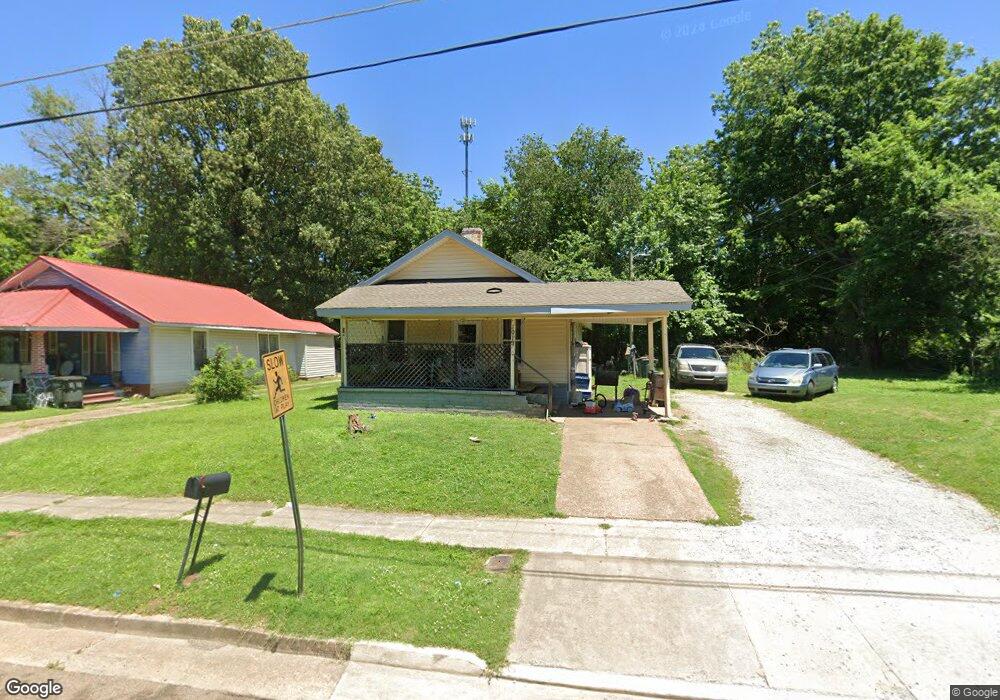
1019 N Division St Union City, TN 38261
Estimated Value: $62,208 - $99,000
--
Bed
1
Bath
1,100
Sq Ft
$74/Sq Ft
Est. Value
About This Home
This home is located at 1019 N Division St, Union City, TN 38261 and is currently estimated at $81,052, approximately $73 per square foot. 1019 N Division St is a home located in Obion County with nearby schools including Union City Elementary School, Union City Middle School, and Union City High School.
Ownership History
Date
Name
Owned For
Owner Type
Purchase Details
Closed on
Dec 26, 2007
Bought by
Adams Ralph E and Adams Bobbie Jane
Current Estimated Value
Purchase Details
Closed on
Jan 3, 2006
Bought by
Goodrich Matthew Steven
Purchase Details
Closed on
Apr 4, 2003
Bought by
Brown Christopher Alan
Purchase Details
Closed on
Mar 18, 1997
Sold by
First Volunteer Bank
Bought by
Scheland Charles T
Purchase Details
Closed on
Jun 29, 1995
Sold by
Moore James R
Bought by
First Volunteer Bank
Purchase Details
Closed on
Feb 23, 1989
Bought by
Moore James R
Purchase Details
Closed on
Jan 1, 1982
Bought by
Sullivan Donald B and Sullivan Glenda
Create a Home Valuation Report for This Property
The Home Valuation Report is an in-depth analysis detailing your home's value as well as a comparison with similar homes in the area
Home Values in the Area
Average Home Value in this Area
Purchase History
| Date | Buyer | Sale Price | Title Company |
|---|---|---|---|
| Adams Ralph E | -- | -- | |
| Goodrich Matthew Steven | $5,000 | -- | |
| Brown Christopher Alan | $10,000 | -- | |
| Scheland Charles T | $29,100 | -- | |
| First Volunteer Bank | $23,500 | -- | |
| Moore James R | $20,000 | -- | |
| Sullivan Donald B | $17,000 | -- |
Source: Public Records
Tax History Compared to Growth
Tax History
| Year | Tax Paid | Tax Assessment Tax Assessment Total Assessment is a certain percentage of the fair market value that is determined by local assessors to be the total taxable value of land and additions on the property. | Land | Improvement |
|---|---|---|---|---|
| 2025 | -- | $11,150 | $0 | $0 |
| 2024 | -- | $11,150 | $1,500 | $9,650 |
| 2023 | $313 | $11,150 | $1,500 | $9,650 |
| 2022 | $118 | $7,400 | $1,875 | $5,525 |
| 2021 | $116 | $7,400 | $1,875 | $5,525 |
| 2020 | $118 | $7,400 | $1,875 | $5,525 |
| 2019 | $275 | $7,400 | $1,875 | $5,525 |
| 2018 | $273 | $7,400 | $1,875 | $5,525 |
| 2017 | $254 | $6,650 | $1,250 | $5,400 |
| 2016 | $254 | $6,650 | $1,250 | $5,400 |
| 2015 | $252 | $6,650 | $1,250 | $5,400 |
| 2014 | $252 | $6,650 | $1,250 | $5,400 |
Source: Public Records
Map
Nearby Homes
- 922 N Division St
- 501 N 1st St
- 724 E Martin Luther King
- 1009 E Cheatham St
- 841 Mosswood Dr
- 0 Mosswood Dr Unit RRA45928
- 0 Mosswood Dr Unit 44704
- 803 E Main St
- 1414 Forest Dr
- 817 Exchange St
- 903 Sherwood Dr
- 610 Perkins St
- 1449 Forest Dr
- 616 S 3rd St
- 605 S 5th St
- 901 S Home St
- 633 E Jackson St
- 422-426 430 W Jackson St
- 1129 S 4th St
- 1813 E Vine St
- 1015 N Division St
- 1025 N Division St
- 1013 N Division St
- 1029 N Division St
- 1007 N Division St
- 1020 N Division St
- 1016 N Division St
- 1003 N Division St
- 1024 N Division St
- 1008 N Division St
- 1012 N Division St
- 1028 N Division St
- 1004 N Division St
- 923 N Division St Unit 925
- 407 E Todd St Unit 409
- 491015 Baker St
- 1013 Baker St
- 1021 Baker St
- 306 E Todd St
- 1009 Baker St