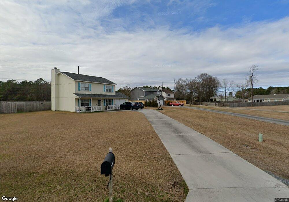
104 Reese Ln Hubert, NC 28539
Hubert NeighborhoodEstimated Value: $271,000 - $284,091
3
Beds
3
Baths
1,740
Sq Ft
$159/Sq Ft
Est. Value
About This Home
This home is located at 104 Reese Ln, Hubert, NC 28539 and is currently estimated at $277,273, approximately $159 per square foot. 104 Reese Ln is a home located in Onslow County with nearby schools including Sand Ridge Elementary School, Swansboro Middle School, and Swansboro High School.
Ownership History
Date
Name
Owned For
Owner Type
Purchase Details
Closed on
Feb 13, 2005
Sold by
Hurst Law Group Inc
Bought by
Louden Brian J and Louden Keiko T
Current Estimated Value
Home Financials for this Owner
Home Financials are based on the most recent Mortgage that was taken out on this home.
Original Mortgage
$30,000
Interest Rate
6.04%
Mortgage Type
Credit Line Revolving
Create a Home Valuation Report for This Property
The Home Valuation Report is an in-depth analysis detailing your home's value as well as a comparison with similar homes in the area
Home Values in the Area
Average Home Value in this Area
Purchase History
| Date | Buyer | Sale Price | Title Company |
|---|---|---|---|
| Louden Brian J | $150,000 | None Available | |
| Hurst Law Group Inc | -- | None Available |
Source: Public Records
Mortgage History
| Date | Status | Borrower | Loan Amount |
|---|---|---|---|
| Previous Owner | Hurst Law Group Inc | $30,000 | |
| Previous Owner | Hurst Law Group Inc | $120,000 |
Source: Public Records
Tax History
| Year | Tax Paid | Tax Assessment Tax Assessment Total Assessment is a certain percentage of the fair market value that is determined by local assessors to be the total taxable value of land and additions on the property. | Land | Improvement |
|---|---|---|---|---|
| 2025 | $1,415 | $216,079 | $40,000 | $176,079 |
| 2024 | $1,415 | $216,079 | $40,000 | $176,079 |
| 2023 | $1,415 | $216,079 | $40,000 | $176,079 |
| 2022 | $1,415 | $216,079 | $40,000 | $176,079 |
| 2021 | $1,163 | $164,930 | $30,000 | $134,930 |
| 2020 | $1,163 | $164,930 | $30,000 | $134,930 |
| 2019 | $1,163 | $164,930 | $30,000 | $134,930 |
| 2018 | $1,163 | $164,930 | $30,000 | $134,930 |
| 2017 | $1,126 | $166,860 | $30,000 | $136,860 |
| 2016 | $1,126 | $166,860 | $0 | $0 |
| 2015 | $1,126 | $166,860 | $0 | $0 |
| 2014 | $1,126 | $166,860 | $0 | $0 |
Source: Public Records
Map
Nearby Homes
- 327 Buckhead Rd
- 290 Parnell Rd
- 127 Glenwood Dr
- 442 Dion Dr
- 243 Zachary Ln
- 128 Daphne Dr
- 153 Glenwood Dr
- 306 Foxtrace Ln
- 406 Foxtrace Ln
- 405 Hooks Ln
- 601 Cannon Ct
- 423 Dion Dr
- 166 Glenwood Dr
- 203 Inman Ct
- 280 Surfside Landing Blvd Unit Lot 113
- 277 Surfside Landing Blvd
- 277 Surfside Landing Blvd Unit Lot 115
- 170 McCausley Rd Unit 10
- 104 Crown Point Rd
- 412 Foxtrace Ln
Your Personal Tour Guide
Ask me questions while you tour the home.