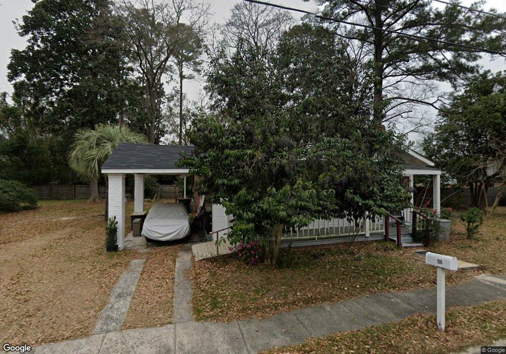
106 S Baker St Glennville, GA 30427
Estimated Value: $97,000 - $136,000
--
Bed
1
Bath
1,008
Sq Ft
$115/Sq Ft
Est. Value
About This Home
This home is located at 106 S Baker St, Glennville, GA 30427 and is currently estimated at $116,260, approximately $115 per square foot. 106 S Baker St is a home located in Tattnall County with nearby schools including Tattnall County High School and Glennville Christian Academy.
Ownership History
Date
Name
Owned For
Owner Type
Purchase Details
Closed on
Oct 17, 2024
Sold by
King Linda Carter
Bought by
Southcoast Holdings Llc
Current Estimated Value
Purchase Details
Closed on
Aug 6, 2008
Sold by
Williams James R
Bought by
King Linda Carter
Purchase Details
Closed on
Oct 30, 2007
Sold by
Lemon Charlotte J
Bought by
Williams James
Purchase Details
Closed on
Oct 1, 2004
Sold by
Secretary Of Housing And
Bought by
Lemon Evart K and Lemon Charlotte
Purchase Details
Closed on
Mar 2, 2004
Sold by
Countrywide Homes Loan Inc
Bought by
Secretary Of Housing And
Purchase Details
Closed on
Jun 30, 1989
Bought by
Bieling Larry L
Create a Home Valuation Report for This Property
The Home Valuation Report is an in-depth analysis detailing your home's value as well as a comparison with similar homes in the area
Home Values in the Area
Average Home Value in this Area
Purchase History
| Date | Buyer | Sale Price | Title Company |
|---|---|---|---|
| Southcoast Holdings Llc | -- | -- | |
| King Linda Carter | $15,000 | -- | |
| Williams James | $28,750 | -- | |
| Lemon Evart K | -- | -- | |
| Secretary Of Housing And | -- | -- | |
| Countrywide Homes Loan Inc | -- | -- | |
| Bieling Larry L | $3,000 | -- |
Source: Public Records
Tax History Compared to Growth
Tax History
| Year | Tax Paid | Tax Assessment Tax Assessment Total Assessment is a certain percentage of the fair market value that is determined by local assessors to be the total taxable value of land and additions on the property. | Land | Improvement |
|---|---|---|---|---|
| 2025 | $690 | $19,520 | $3,160 | $16,360 |
| 2024 | $533 | $14,960 | $3,160 | $11,800 |
| 2023 | $533 | $14,960 | $3,160 | $11,800 |
| 2022 | $457 | $12,840 | $3,160 | $9,680 |
| 2021 | $428 | $12,320 | $3,160 | $9,160 |
| 2020 | $429 | $12,320 | $3,160 | $9,160 |
| 2019 | $420 | $11,760 | $2,400 | $9,360 |
| 2018 | $426 | $11,760 | $2,400 | $9,360 |
| 2017 | $326 | $11,760 | $2,400 | $9,360 |
| 2016 | $93 | $11,640 | $2,400 | $9,240 |
| 2015 | -- | $11,720 | $2,400 | $9,320 |
| 2014 | -- | $11,240 | $2,400 | $8,840 |
| 2013 | -- | $11,240 | $2,400 | $8,840 |
Source: Public Records
Map
Nearby Homes
- 305 S Baker St
- 306 S Tillman St
- 404 S Baker St
- 304 Morris St
- 128 Fate Rd
- 413 Auburn Rd
- 400 W Mann St
- 803 E Barnard St
- 402 W Mann St
- 302 N Church St
- Tract 1 Simon St
- Tract 2 Simon St
- 203 Bull St
- 601 Auburn Rd
- 109 Lincoln Dr
- 105 Widgeon Ln
- 706 Virginia Ave
- 708 Virginia Ave
- 655 N Caswell St
- 653 N Caswell St
- 409 E Barnard St
- 413 E Barnard St
- 110 S Baker St
- 105 S Baker St
- 101 S Baker St
- 109 S Baker St
- 407 E Barnard St
- 505 E Barnard St
- 114 1/2 S Baker St
- 111 S Baker St
- 115 S Baker St
- 507 E Barnard St
- 414 E Barnard St
- 116 S Baker St
- 302 Bolton St
- 306 Bolton St
- 502 E Barnard St
- 315 E Barnard St
- 308 Bolton St
- 513 E Barnard St