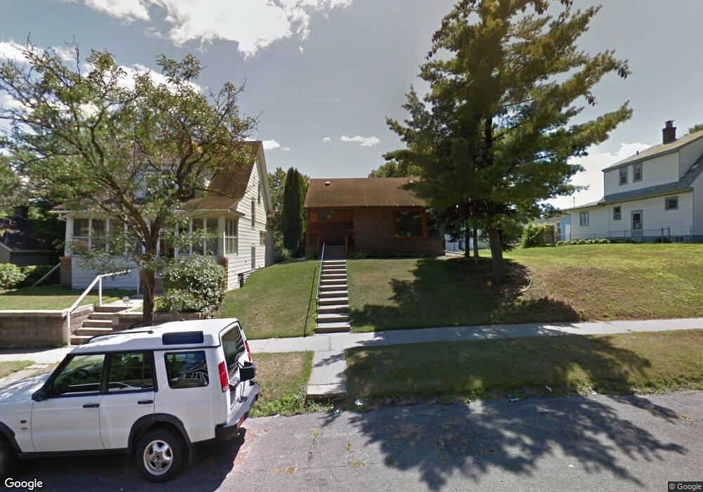
1064 Lafond Ave Saint Paul, MN 55104
Frogtown NeighborhoodEstimated Value: $259,000 - $275,000
2
Beds
2
Baths
1,213
Sq Ft
$222/Sq Ft
Est. Value
About This Home
This home is located at 1064 Lafond Ave, Saint Paul, MN 55104 and is currently estimated at $269,340, approximately $222 per square foot. 1064 Lafond Ave is a home located in Ramsey County with nearby schools including Maxfield Magnet Elementary School, Stockton Borough School, and Hidden River Middle School.
Ownership History
Date
Name
Owned For
Owner Type
Purchase Details
Closed on
May 13, 2022
Sold by
Gebrieye Abiy and Jifar Mahelet
Bought by
Bryant Emma
Current Estimated Value
Home Financials for this Owner
Home Financials are based on the most recent Mortgage that was taken out on this home.
Original Mortgage
$214,400
Outstanding Balance
$202,578
Interest Rate
4.67%
Mortgage Type
New Conventional
Estimated Equity
$66,762
Purchase Details
Closed on
Jan 23, 2017
Sold by
Carlson Erving L and Carlson Jana Lee M
Bought by
Gebrieye Abiy Moges
Home Financials for this Owner
Home Financials are based on the most recent Mortgage that was taken out on this home.
Original Mortgage
$134,400
Interest Rate
4.3%
Mortgage Type
New Conventional
Create a Home Valuation Report for This Property
The Home Valuation Report is an in-depth analysis detailing your home's value as well as a comparison with similar homes in the area
Home Values in the Area
Average Home Value in this Area
Purchase History
| Date | Buyer | Sale Price | Title Company |
|---|---|---|---|
| Bryant Emma | $268,000 | -- | |
| Gebrieye Abiy Moges | $168,000 | Partners Title Llc |
Source: Public Records
Mortgage History
| Date | Status | Borrower | Loan Amount |
|---|---|---|---|
| Open | Bryant Emma | $214,400 | |
| Previous Owner | Gebrieye Abiy Moges | $134,400 |
Source: Public Records
Tax History Compared to Growth
Tax History
| Year | Tax Paid | Tax Assessment Tax Assessment Total Assessment is a certain percentage of the fair market value that is determined by local assessors to be the total taxable value of land and additions on the property. | Land | Improvement |
|---|---|---|---|---|
| 2025 | $3,806 | $254,200 | $25,000 | $229,200 |
| 2023 | $3,806 | $254,400 | $20,000 | $234,400 |
| 2022 | $3,556 | $278,200 | $20,000 | $258,200 |
| 2021 | $3,188 | $222,700 | $20,000 | $202,700 |
| 2020 | $2,944 | $208,000 | $11,200 | $196,800 |
| 2019 | $2,638 | $181,800 | $11,200 | $170,600 |
| 2018 | $1,484 | $165,700 | $11,200 | $154,500 |
| 2017 | $1,442 | $104,000 | $11,200 | $92,800 |
| 2016 | $1,630 | $0 | $0 | $0 |
| 2015 | $1,274 | $95,700 | $11,200 | $84,500 |
| 2014 | $1,368 | $0 | $0 | $0 |
Source: Public Records
Map
Nearby Homes
- 1058 Blair Ave
- 687 Lexington Pkwy N
- 1141 Blair Ave
- 985 Charles Ave
- 1126 Charles Ave
- 1134 Charles Ave
- 936 Thomas Ave
- 931 Sherburne Ave
- 1231 Thomas Ave
- 1229 Lafond Ave
- 1239 Charles Ave
- 1258 Blair Ave
- 1239 Sherburne Ave
- 1263 Charles Ave
- 852 Edmund Ave
- 1153 Central Ave W
- 846 Sherburne Ave
- 816 Edmund Ave
- 1146 Central Ave W
- 1271 Seminary Ave
- 1066 Lafond Ave
- 1054 Lafond Ave
- 1072 Lafond Ave
- 1076 Lafond Ave
- 1061 Thomas Ave
- 1080 Lafond Ave
- 1057 Thomas Ave
- 1065 Thomas Ave
- 1069 Thomas Ave
- 1053 Thomas Ave
- 1082 Lafond Ave
- 1047 Thomas Ave
- 1044 Lafond Ave
- 1065 Lafond Ave
- 1073 Thomas Ave
- 1061 Lafond Ave
- 1069 Lafond Ave
- 1086 Lafond Ave
- 1055 Lafond Ave
- 1045 Thomas Ave