Estimated Value: $915,000 - $1,139,000
4
Beds
3
Baths
2,472
Sq Ft
$419/Sq Ft
Est. Value
About This Home
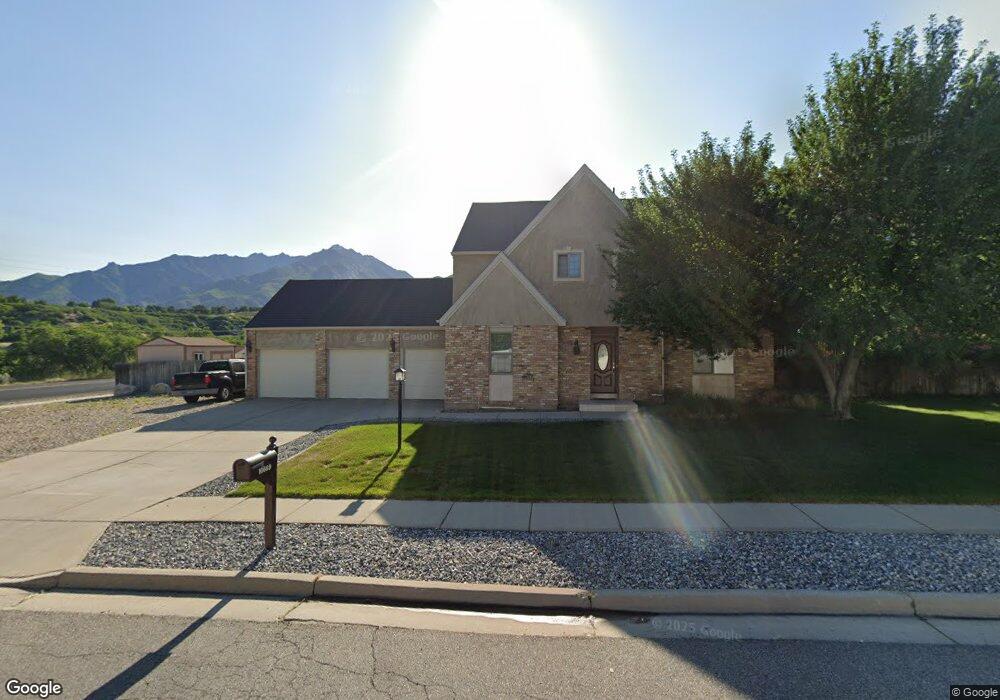
This home is located at 10669 Maple Hill Cir, Sandy, UT 84092 and is currently estimated at $1,035,643, approximately $418 per square foot. 10669 Maple Hill Cir is a home located in Salt Lake County with nearby schools including Granite Elementary School, Bell Canyon Montessori School, and Challenger School - Sandy.
Ownership History
Date
Name
Owned For
Owner Type
Purchase Details
Closed on
May 21, 2009
Sold by
Robinson Dan E and Robinson Christine E
Bought by
Robinson Christine E
Current Estimated Value
Home Financials for this Owner
Home Financials are based on the most recent Mortgage that was taken out on this home.
Original Mortgage
$130,600
Interest Rate
4.82%
Mortgage Type
New Conventional
Purchase Details
Closed on
Sep 23, 1998
Sold by
Robinson Dan E and Robinson Christine E
Bought by
Robinson Christine E
Home Financials for this Owner
Home Financials are based on the most recent Mortgage that was taken out on this home.
Original Mortgage
$155,000
Interest Rate
6.88%
Purchase Details
Closed on
Sep 21, 1998
Sold by
Brown Richard J and Brown Debra S
Bought by
Robinson Dan E and Robinson Christine E
Home Financials for this Owner
Home Financials are based on the most recent Mortgage that was taken out on this home.
Original Mortgage
$155,000
Interest Rate
6.88%
Create a Home Valuation Report for This Property
The Home Valuation Report is an in-depth analysis detailing your home's value as well as a comparison with similar homes in the area
Home Values in the Area
Average Home Value in this Area
Purchase History
| Date | Buyer | Sale Price | Title Company |
|---|---|---|---|
| Robinson Christine E | -- | Absolute Title Ins Agcy Inc | |
| Robinson Dan E | -- | Absolute Title Ins Agecy Inc | |
| Robinson Christine E | -- | None Available | |
| Robinson Dan E | -- | -- |
Source: Public Records
Mortgage History
| Date | Status | Borrower | Loan Amount |
|---|---|---|---|
| Closed | Robinson Dan E | $130,600 | |
| Closed | Robinson Dan E | $155,000 |
Source: Public Records
Tax History
| Year | Tax Paid | Tax Assessment Tax Assessment Total Assessment is a certain percentage of the fair market value that is determined by local assessors to be the total taxable value of land and additions on the property. | Land | Improvement |
|---|---|---|---|---|
| 2025 | $4,993 | $846,400 | $330,300 | $516,100 |
| 2024 | $4,993 | $764,100 | $318,000 | $446,100 |
| 2023 | $4,993 | $688,200 | $305,700 | $382,500 |
| 2022 | $4,700 | $695,700 | $295,000 | $400,700 |
| 2021 | $4,175 | $541,200 | $216,100 | $325,100 |
| 2020 | $4,330 | $523,800 | $216,100 | $307,700 |
| 2019 | $4,061 | $487,900 | $203,800 | $284,100 |
| 2018 | $3,927 | $476,800 | $203,800 | $273,000 |
| 2017 | $3,596 | $427,200 | $203,800 | $223,400 |
| 2016 | $3,295 | $383,900 | $187,700 | $196,200 |
| 2015 | $3,233 | $350,200 | $267,000 | $83,200 |
| 2014 | $3,152 | $331,700 | $260,400 | $71,300 |
Source: Public Records
Map
Nearby Homes
- 2342 Charros Rd
- 10665 S 2340 E
- 2026 E 10765 S
- 16 Gatehouse Ln
- 5 Quietwood Ln
- 1 Quietwood Ln
- 7 Rollingwood Ln
- 1 Pepperwood Pointe
- 2009 E Sweetbriar Ln
- 11129 S 2125 E
- 10286 S Edgecliff Dr
- 2234 E Willow Brook Way
- 1602 E Sego Lily Dr
- 10868 Prescott Dr
- 10870 S Lostwood Dr
- 2170 E Borg Ct
- 10804 S Hiddenwood Dr
- 9942 S Altamont Dr
- 10158 Buttercup Dr
- 11446 S 2320 E
- 2192 E Dimple Dell Rd
- 2192 Dimple Dell Rd
- 10689 Maple Hill Cir
- 2180 Dimple Dell Rd
- 2180 E Dimple Dell Rd
- 2204 E Dimple Dell Rd
- 2204 Dimple Dell Rd
- 10696 Maple Hill Cir
- 10381 Dimple Dell Rd Unit 4
- 2884 Dimple Dell Rd
- 10692 Stone Gate Cir
- 10692 S Stone Gate Cir
- 10713 Maple Hill Cir
- 10661 S Trailridge Cir
- 10661 Trailridge Cir
- 10661 Trail Ridge Cir
- 10681 Trailridge Cir
- 10718 Maple Hill Cir
- 10704 Stone Gate Cir
- 10667 S Stone Gate Cir
Your Personal Tour Guide
Ask me questions while you tour the home.