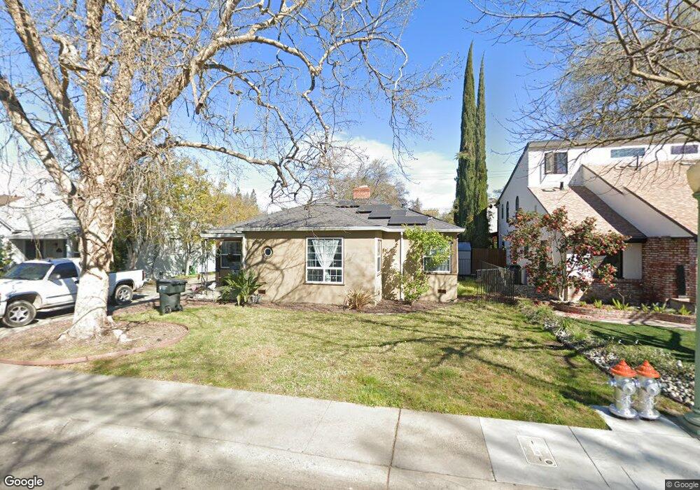
1081 Perkins Way Sacramento, CA 95818
Upper Land Park NeighborhoodEstimated Value: $654,360 - $791,000
3
Beds
1
Bath
1,284
Sq Ft
$573/Sq Ft
Est. Value
About This Home
This home is located at 1081 Perkins Way, Sacramento, CA 95818 and is currently estimated at $735,340, approximately $572 per square foot. 1081 Perkins Way is a home located in Sacramento County with nearby schools including Crocker/Riverside Elementary School, California Middle, and C. K. McClatchy High.
Ownership History
Date
Name
Owned For
Owner Type
Purchase Details
Closed on
Aug 2, 2019
Sold by
Reese Lissa
Bought by
Hoover Todd R
Current Estimated Value
Purchase Details
Closed on
Nov 14, 2006
Sold by
Hoover George D and Hoover Beverly
Bought by
Hoover Todd R
Purchase Details
Closed on
May 25, 2006
Sold by
Hoover George D and Hoover Beverly
Bought by
Hoover Todd R
Create a Home Valuation Report for This Property
The Home Valuation Report is an in-depth analysis detailing your home's value as well as a comparison with similar homes in the area
Home Values in the Area
Average Home Value in this Area
Purchase History
| Date | Buyer | Sale Price | Title Company |
|---|---|---|---|
| Hoover Todd R | -- | None Available | |
| Hoover Todd R | -- | Commonwealth Land Title Co | |
| Hoover Todd R | -- | None Available |
Source: Public Records
Tax History Compared to Growth
Tax History
| Year | Tax Paid | Tax Assessment Tax Assessment Total Assessment is a certain percentage of the fair market value that is determined by local assessors to be the total taxable value of land and additions on the property. | Land | Improvement |
|---|---|---|---|---|
| 2025 | $2,843 | $229,847 | $141,449 | $88,398 |
| 2024 | $2,843 | $225,341 | $138,676 | $86,665 |
| 2023 | $2,776 | $220,923 | $135,957 | $84,966 |
| 2022 | $2,728 | $216,592 | $133,292 | $83,300 |
| 2021 | $2,603 | $212,346 | $130,679 | $81,667 |
| 2020 | $2,619 | $210,170 | $129,340 | $80,830 |
| 2019 | $2,564 | $206,050 | $126,804 | $79,246 |
| 2018 | $2,497 | $202,011 | $124,318 | $77,693 |
| 2017 | $2,462 | $198,051 | $121,881 | $76,170 |
| 2016 | $2,389 | $194,169 | $119,492 | $74,677 |
| 2015 | $2,353 | $191,254 | $117,698 | $73,556 |
| 2014 | $2,292 | $187,509 | $115,393 | $72,116 |
Source: Public Records
Map
Nearby Homes
- 3098 Riverside Blvd
- 849 8th Ave
- 625 Robertson Way
- 710 7th Ave
- 613 Swanston Dr
- 749 3rd Ave Unit 3
- 1032 10th Ave
- 808 Fremont Way
- 941 McClatchy Way
- 1432 Teneighth Way
- 2766 San Luis Ct
- 2756 San Luis Ct
- 601 Dudley Way
- 1615 Vallejo Way
- 1701 9th Ave
- 2726 Moonflower St
- 2750 Moonflower St
- 1259 Milano Dr Unit 2
- 1725 Vallejo Way
- 2780 Harkness St
- 1085 Perkins Way
- 1075 Perkins Way
- 1071 Perkins Way
- 1087 Perkins Way
- 1067 Perkins Way
- 1091 Perkins Way
- 1082 Perkins Way
- 1078 Perkins Way
- 1086 Perkins Way
- 1074 Perkins Way
- 1063 Perkins Way
- 1090 Perkins Way
- 1070 Perkins Way
- 1059 Perkins Way
- 1066 Perkins Way
- 3074 Riverside Blvd
- 1062 Perkins Way
- 1055 Perkins Way
- 1101 Perkins Way
- 2973 Riverside Blvd