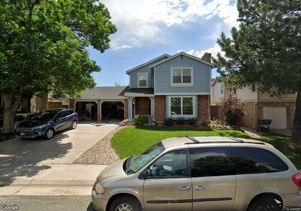
10971 Main Range Trail Littleton, CO 80127
Ken Caryl Ranch NeighborhoodEstimated Value: $644,000 - $719,000
About This Home
This home is located at 10971 Main Range Trail, Littleton, CO 80127 and is currently estimated at $693,446, approximately $327 per square foot. 10971 Main Range Trail is a home located in Jefferson County with nearby schools including Shaffer Elementary School, Falcon Bluffs Middle School, and Chatfield High School.
Ownership History
We collect this data history from publicly available records. To have your information removed, we recommend requesting removal directly through your county’s website.
Purchase Details
Home Financials for this Owner
Home Financials are based on the most recent Mortgage that was taken out on this home.Purchase Details
Purchase Details
Home Financials for this Owner
Home Financials are based on the most recent Mortgage that was taken out on this home.Home Values in the Area
Average Home Value in this Area
Purchase History
We collect this data history from publicly available records. To have your information removed, we recommend requesting removal directly through your county’s website.
| Date | Buyer | Sale Price | Title Company |
|---|---|---|---|
| $283,000 | Land Title Guarantee Company | ||
| -- | -- | ||
| $184,900 | First American |
Mortgage History
We collect this data history from publicly available records. To have your information removed, we recommend requesting removal directly through your county’s website.
| Date | Status | Borrower | Loan Amount |
|---|---|---|---|
| Closed | $56,600 | ||
| Open | $226,400 | ||
| Previous Owner | $147,900 |
Tax History
We collect this data history from publicly available records. To have your information removed, we recommend requesting removal directly through your county’s website.
| Year | Tax Paid | Tax Assessment Tax Assessment Total Assessment is a certain percentage of the fair market value that is determined by local assessors to be the total taxable value of land and additions on the property. | Land | Improvement |
|---|---|---|---|---|
| 2025 | $4,439 | $40,266 | $10,673 | $29,593 |
| 2024 | $4,190 | $39,135 | $10,330 | $28,805 |
| 2023 | $4,190 | $39,135 | $10,330 | $28,805 |
| 2022 | $3,741 | $34,174 | $8,377 | $25,797 |
| 2021 | $3,798 | $35,158 | $8,618 | $26,540 |
| 2020 | $3,358 | $31,186 | $6,902 | $24,284 |
| 2019 | $3,318 | $31,186 | $6,902 | $24,284 |
| 2018 | $2,964 | $26,901 | $6,750 | $20,151 |
| 2017 | $2,756 | $26,901 | $6,750 | $20,151 |
| 2016 | $2,900 | $26,785 | $8,429 | $18,356 |
| 2015 | $2,587 | $26,785 | $8,429 | $18,356 |
| 2014 | $2,587 | $22,517 | $6,685 | $15,832 |
Map
- 7643 Sunshine Peak
- 7573 S Mount Zirkel
- 7611 S Lost Ranger Peak
- 10627 W Chautauga Mountain
- 10708 W Chautauga Mountain
- 7533 S Mount Zirkel
- 10792 W Indore Dr
- 11059 W Pyramid Peak
- 10866 W Half Moon Pass
- 7448 S Quail Cir Unit 2214
- 8200 S San Juan Range Rd
- 7438 S Quail Cir Unit 2026
- 7453 S Quail Cir Unit 221
- 8074 S Trinchera Peak
- 7463 S Quail Cir Unit 312
- 7463 S Quail Cir Unit 336
- 7493 S Quail Cir Unit 926
- 11675 Elk Head Range Rd
- 7423 S Quail Cir Unit 1535
- 8093 S Vermejo Peak
- 10981 Main Range Trail
- 10951 Main Range Trail
- 10972 Main Range Trail
- 10941 Main Range Trail
- 7658 Snowmass Mountain
- 10962 Main Range Trail
- 10982 Main Range Trail
- 10695 W Devils Head
- 10931 Main Range Trail
- 7648 Snowmass Mountain
- 7657 Snowmass Mountain
- 10952 Main Range Trail
- 10992 Main Range Trail
- 7707 Gunsight Pass
- 10921 Main Range Trail
- 7638 Snowmass Mountain
- 7647 Snowmass Mountain
- 10675 W Devils Head
- 10942 Main Range Trail
- 10706 W Devils Head
Ask me questions while you tour the home.