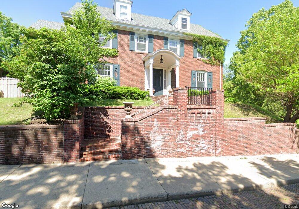
11 Kenwood Pkwy Saint Paul, MN 55105
Summit Hill NeighborhoodEstimated Value: $1,276,535 - $1,448,000
4
Beds
5
Baths
5,800
Sq Ft
$238/Sq Ft
Est. Value
About This Home
This home is located at 11 Kenwood Pkwy, Saint Paul, MN 55105 and is currently estimated at $1,381,512, approximately $238 per square foot. 11 Kenwood Pkwy is a home located in Ramsey County with nearby schools including Randolph Heights Elementary School, Hidden River Middle School, and Central Senior High School.
Ownership History
Date
Name
Owned For
Owner Type
Purchase Details
Closed on
Jan 18, 2017
Sold by
Boston Michele K and Boston Jennfrey T
Bought by
Miller George Hans and Tichier Anne
Current Estimated Value
Home Financials for this Owner
Home Financials are based on the most recent Mortgage that was taken out on this home.
Original Mortgage
$415,500
Outstanding Balance
$211,304
Interest Rate
4.69%
Mortgage Type
Adjustable Rate Mortgage/ARM
Estimated Equity
$1,170,208
Purchase Details
Closed on
Sep 30, 2016
Sold by
Boston Michele K and Boston Jeffrey T
Bought by
Miller George Hans and Tichich Anne
Home Financials for this Owner
Home Financials are based on the most recent Mortgage that was taken out on this home.
Original Mortgage
$417,000
Interest Rate
4.16%
Mortgage Type
New Conventional
Purchase Details
Closed on
Apr 30, 2003
Sold by
David Owens R and David Enid Owens
Bought by
Bausch & Lomb Inc
Create a Home Valuation Report for This Property
The Home Valuation Report is an in-depth analysis detailing your home's value as well as a comparison with similar homes in the area
Home Values in the Area
Average Home Value in this Area
Purchase History
| Date | Buyer | Sale Price | Title Company |
|---|---|---|---|
| Miller George Hans | $978,787 | Burnet Title | |
| Miller George Hans | $950,000 | Burnet Title | |
| Bausch & Lomb Inc | $910,000 | -- |
Source: Public Records
Mortgage History
| Date | Status | Borrower | Loan Amount |
|---|---|---|---|
| Open | Miller George Hans | $415,500 | |
| Previous Owner | Miller George Hans | $417,000 |
Source: Public Records
Tax History Compared to Growth
Tax History
| Year | Tax Paid | Tax Assessment Tax Assessment Total Assessment is a certain percentage of the fair market value that is determined by local assessors to be the total taxable value of land and additions on the property. | Land | Improvement |
|---|---|---|---|---|
| 2025 | $20,026 | $1,295,600 | $233,000 | $1,062,600 |
| 2023 | $20,026 | $1,166,200 | $233,000 | $933,200 |
| 2022 | $18,178 | $1,098,500 | $233,000 | $865,500 |
| 2021 | $18,612 | $1,002,400 | $233,000 | $769,400 |
| 2020 | $19,490 | $1,075,900 | $233,000 | $842,900 |
| 2019 | $19,748 | $1,047,100 | $233,000 | $814,100 |
| 2018 | $18,164 | $1,039,200 | $233,000 | $806,200 |
| 2017 | $17,244 | $989,300 | $267,900 | $721,400 |
| 2016 | $17,730 | $0 | $0 | $0 |
| 2015 | $18,438 | $945,200 | $267,900 | $677,300 |
| 2014 | $19,052 | $0 | $0 | $0 |
Source: Public Records
Map
Nearby Homes
- 670 Lincoln Ave
- 657 Lincoln Ave
- 695 Lincoln Ave
- 195 Oneida St
- 614 Grand Ave Unit C
- 614 Grand Ave Unit 3EE
- 793 Goodrich Ave
- 635 Grand Ave Unit 4
- 745 Grand Ave Unit 404
- 28 Dale St S Unit A
- 63 Avon St S Unit 36
- 51 Avon St S Unit 24
- 857 Fairmount Ave
- 582 Summit Ave
- 28 Saint Albans St N Unit 4N
- 21 Avon St S Unit 21
- 562 Summit Ave Unit 4
- 389 Osceola Ave S
- 579 Summit Ave Unit 105
- 385 Toronto St
- 680 Fairmount Ave
- 682 Fairmount Ave
- 18 Kenwood Pkwy
- 666 Fairmount Ave
- 670 Fairmount Ave
- 19 Kenwood Pkwy
- 686 Fairmount Ave
- 25 Kenwood Pkwy
- 654 Fairmount Ave
- 688 Fairmount Ave
- 26 Kenwood Pkwy
- 0 Kenwood Pkwy
- 692 Fairmount Ave
- 691 Osceola Ave
- 677 Fairmount Ave Unit 1
- 677 Fairmount Ave Unit 2
- 677 Fairmount Ave
- 677 677 Fairmount Ave
- 671 Fairmount Ave
- 665 Fairmount Ave