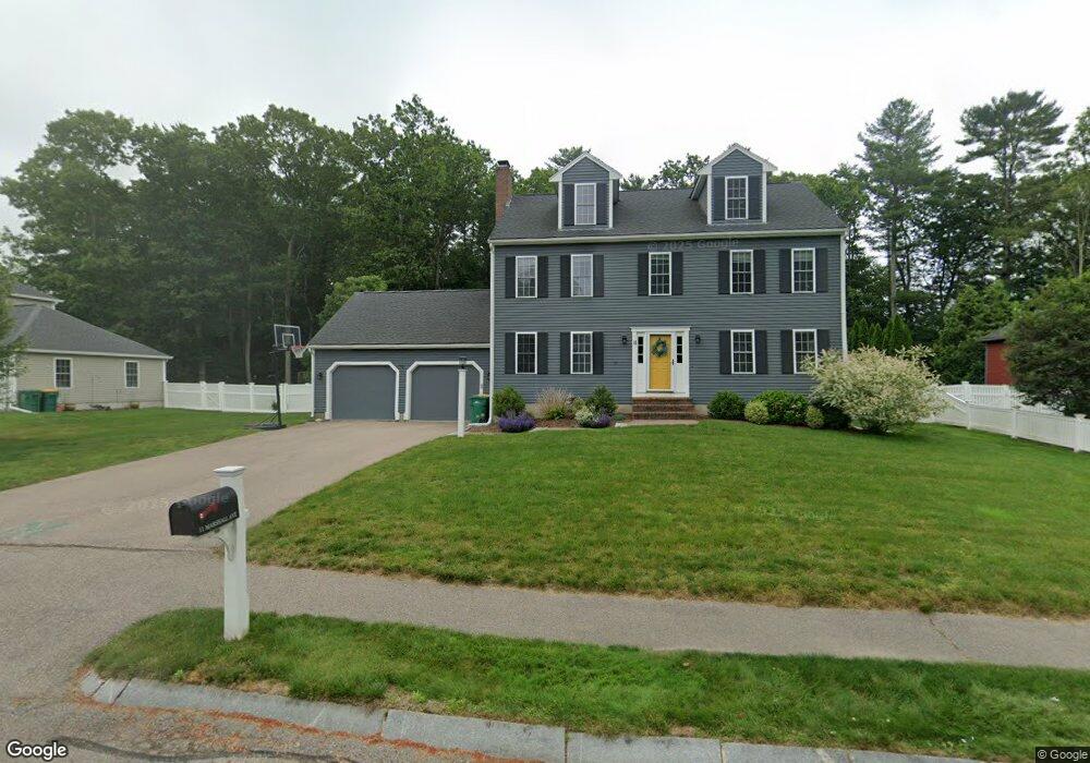
11 Marshall Ave Mansfield, MA 02048
Estimated Value: $823,958 - $941,000
4
Beds
3
Baths
2,128
Sq Ft
$424/Sq Ft
Est. Value
About This Home
This home is located at 11 Marshall Ave, Mansfield, MA 02048 and is currently estimated at $901,490, approximately $423 per square foot. 11 Marshall Ave is a home located in Bristol County with nearby schools including Everett W. Robinson Elementary School, Jordan/Jackson Elementary School, and Harold L. Qualters Middle School.
Ownership History
Date
Name
Owned For
Owner Type
Purchase Details
Closed on
Nov 30, 2017
Sold by
Tully Bernard J and Tully Paula D
Bought by
Hernon Brooke and Hernon Thomas
Current Estimated Value
Home Financials for this Owner
Home Financials are based on the most recent Mortgage that was taken out on this home.
Original Mortgage
$517,500
Outstanding Balance
$430,635
Interest Rate
3.5%
Mortgage Type
New Conventional
Estimated Equity
$470,855
Create a Home Valuation Report for This Property
The Home Valuation Report is an in-depth analysis detailing your home's value as well as a comparison with similar homes in the area
Home Values in the Area
Average Home Value in this Area
Purchase History
| Date | Buyer | Sale Price | Title Company |
|---|---|---|---|
| Hernon Brooke | $545,000 | -- |
Source: Public Records
Mortgage History
| Date | Status | Borrower | Loan Amount |
|---|---|---|---|
| Open | Hernon Brooke | $517,500 |
Source: Public Records
Tax History Compared to Growth
Tax History
| Year | Tax Paid | Tax Assessment Tax Assessment Total Assessment is a certain percentage of the fair market value that is determined by local assessors to be the total taxable value of land and additions on the property. | Land | Improvement |
|---|---|---|---|---|
| 2025 | $9,436 | $716,500 | $275,600 | $440,900 |
| 2024 | $9,065 | $671,500 | $287,600 | $383,900 |
| 2023 | $8,777 | $622,900 | $287,600 | $335,300 |
| 2022 | $8,441 | $556,400 | $266,200 | $290,200 |
| 2021 | $8,231 | $535,900 | $222,000 | $313,900 |
| 2020 | $8,104 | $527,600 | $222,000 | $305,600 |
| 2019 | $7,508 | $493,300 | $184,900 | $308,400 |
| 2018 | $7,461 | $479,200 | $176,300 | $302,900 |
| 2017 | $6,996 | $465,800 | $171,200 | $294,600 |
| 2016 | $6,665 | $432,500 | $163,000 | $269,500 |
| 2015 | $6,491 | $418,800 | $163,000 | $255,800 |
Source: Public Records
Map
Nearby Homes
- 414 Branch St
- 460 Ware St
- 442 Ware St
- 28 Court St
- 18 Columbine Rd
- 15 Reservoir St Unit 44
- 150 Rumford Ave Unit 110
- 22 Pleasant St Unit C
- 82 Brook St
- 15 Rock Ln
- Lot 3 Birch Ln
- 166 Chauncy St
- 631 East St Unit E203
- 21 Juniper Rd
- 277 Central St
- 212 Mill St
- 28 Angell St
- 44 Angell St Unit 44
- 12 Sylvan Rd
- 619 N Main St