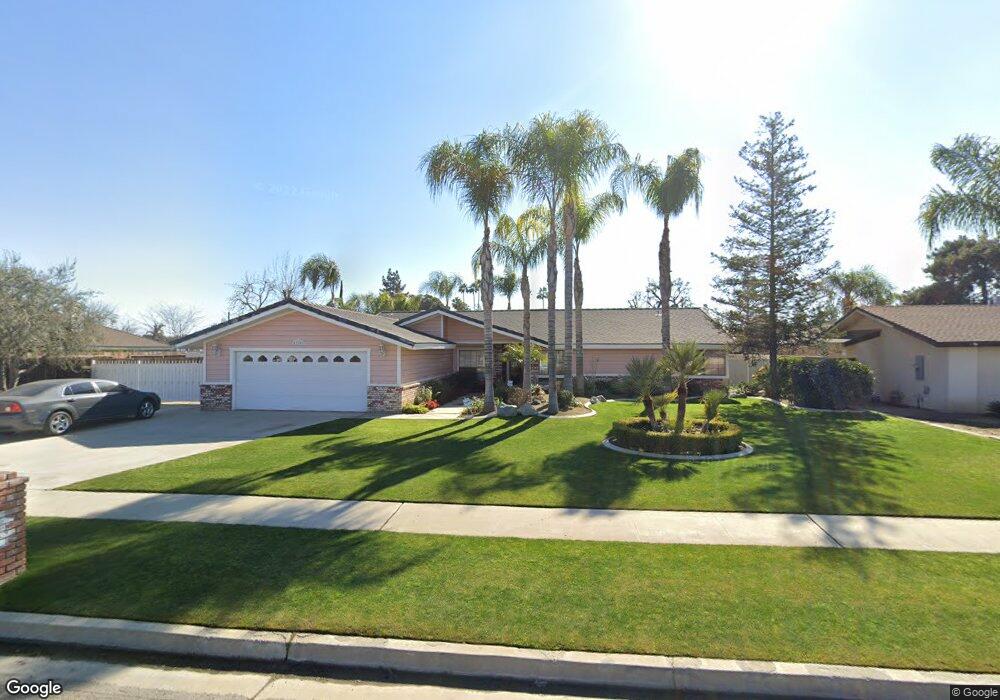
11101 Aimee Way Bakersfield, CA 93312
Polo Grounds NeighborhoodEstimated Value: $443,000 - $599,000
4
Beds
2
Baths
2,057
Sq Ft
$245/Sq Ft
Est. Value
About This Home
This home is located at 11101 Aimee Way, Bakersfield, CA 93312 and is currently estimated at $503,247, approximately $244 per square foot. 11101 Aimee Way is a home located in Kern County with nearby schools including Rosedale-North Elementary School, Freedom Middle School, and Centennial High School.
Ownership History
Date
Name
Owned For
Owner Type
Purchase Details
Closed on
Mar 20, 2024
Sold by
Moreau Patsy A
Bought by
Patsy Moreau Trust and Moreau
Current Estimated Value
Purchase Details
Closed on
Oct 31, 1995
Sold by
Stuckey Donald P and Stuckey Carla R
Bought by
Moreau Alfred N and Moreau Patsy A
Home Financials for this Owner
Home Financials are based on the most recent Mortgage that was taken out on this home.
Original Mortgage
$149,350
Interest Rate
7.47%
Mortgage Type
Assumption
Create a Home Valuation Report for This Property
The Home Valuation Report is an in-depth analysis detailing your home's value as well as a comparison with similar homes in the area
Home Values in the Area
Average Home Value in this Area
Purchase History
| Date | Buyer | Sale Price | Title Company |
|---|---|---|---|
| Patsy Moreau Trust | -- | None Listed On Document | |
| Moreau Alfred N | $145,000 | First American Title |
Source: Public Records
Mortgage History
| Date | Status | Borrower | Loan Amount |
|---|---|---|---|
| Previous Owner | Moreau Alfred N | $149,350 |
Source: Public Records
Tax History Compared to Growth
Tax History
| Year | Tax Paid | Tax Assessment Tax Assessment Total Assessment is a certain percentage of the fair market value that is determined by local assessors to be the total taxable value of land and additions on the property. | Land | Improvement |
|---|---|---|---|---|
| 2025 | $3,402 | $257,122 | $66,433 | $190,689 |
| 2024 | $3,322 | $252,082 | $65,131 | $186,951 |
| 2023 | $3,322 | $247,141 | $63,854 | $183,287 |
| 2022 | $3,232 | $242,296 | $62,602 | $179,694 |
| 2021 | $3,121 | $237,547 | $61,375 | $176,172 |
| 2020 | $3,056 | $235,112 | $60,746 | $174,366 |
| 2019 | $3,009 | $235,112 | $60,746 | $174,366 |
| 2018 | $2,911 | $225,985 | $58,388 | $167,597 |
| 2017 | $2,879 | $221,556 | $57,244 | $164,312 |
| 2016 | $2,681 | $217,213 | $56,122 | $161,091 |
| 2015 | $2,649 | $213,951 | $55,279 | $158,672 |
| 2014 | $2,588 | $209,762 | $54,197 | $155,565 |
Source: Public Records
Map
Nearby Homes
- 3108 Holbrook St
- 11201 Paddock Ave
- 11617 Cactus Dr
- 11705 Cactus Dr
- 3435 Moss St
- 3122 Campfire Dr Unit 2
- 10729 Lindalee Ln
- 10701 Meacham Rd
- 2125 Verdugo Ln
- 3613 Aslin St
- 2008 Torrey Dr
- 10429 Enger St
- 11407 Palm Ave
- 11908 Nebula Ct
- 11520 Pinehaven Ave
- 11910 Compass Ave
- 3622 Azure Dr
- 10920 Cilantro Ave
- 11265 Poulsen Way
- 10601 Michele Ave
- 11017 Aimee Way
- 11109 Aimee Way
- 11009 Aimee Way
- 11117 Aimee Way
- 11108 Aimee Way
- 11100 Aimee Way
- 11001 Aimee Way
- 2701 Nicole Way
- 11116 Aimee Way
- 11209 Aimee Way
- 11200 Aimee Way
- 2709 Nicole Way
- 11009 Rosedale Hwy
- 11017 Rosedale Hwy
- 11001 Rosedale Hwy
- 11109 Dee Dee Ct
- 11208 Aimee Way
- 11101 Dee Dee Ct
- 11217 Aimee Way
- 2801 Nicole Way