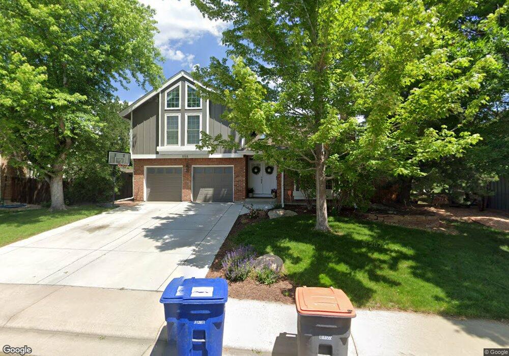
11111 Main Range Trail Littleton, CO 80127
Ken Caryl Ranch NeighborhoodEstimated Value: $904,000 - $996,000
6
Beds
4
Baths
3,636
Sq Ft
$256/Sq Ft
Est. Value
About This Home
This home is located at 11111 Main Range Trail, Littleton, CO 80127 and is currently estimated at $929,759, approximately $255 per square foot. 11111 Main Range Trail is a home located in Jefferson County with nearby schools including Shaffer Elementary School, Falcon Bluffs Middle School, and Chatfield High School.
Ownership History
Date
Name
Owned For
Owner Type
Purchase Details
Closed on
Aug 22, 2024
Sold by
Mcguire William E and Mcguire Lydia R
Bought by
Mcguire Family Trust and Mcguire
Current Estimated Value
Purchase Details
Closed on
May 2, 2022
Sold by
Downs Robert S
Bought by
Mcguire William E and Mcguire Lydia R
Home Financials for this Owner
Home Financials are based on the most recent Mortgage that was taken out on this home.
Original Mortgage
$563,200
Interest Rate
4.42%
Mortgage Type
New Conventional
Create a Home Valuation Report for This Property
The Home Valuation Report is an in-depth analysis detailing your home's value as well as a comparison with similar homes in the area
Home Values in the Area
Average Home Value in this Area
Purchase History
| Date | Buyer | Sale Price | Title Company |
|---|---|---|---|
| Mcguire Family Trust | -- | None Listed On Document | |
| Mcguire William E | $1,012,000 | First American Title |
Source: Public Records
Mortgage History
| Date | Status | Borrower | Loan Amount |
|---|---|---|---|
| Previous Owner | Mcguire William E | $563,200 |
Source: Public Records
Tax History
| Year | Tax Paid | Tax Assessment Tax Assessment Total Assessment is a certain percentage of the fair market value that is determined by local assessors to be the total taxable value of land and additions on the property. | Land | Improvement |
|---|---|---|---|---|
| 2024 | $5,944 | $55,521 | $13,250 | $42,271 |
| 2023 | $5,944 | $55,521 | $13,250 | $42,271 |
| 2022 | $4,456 | $40,703 | $10,536 | $30,167 |
| 2021 | $4,524 | $41,874 | $10,839 | $31,035 |
| 2020 | $4,096 | $38,039 | $9,833 | $28,206 |
| 2019 | $4,048 | $38,039 | $9,833 | $28,206 |
| 2018 | $3,727 | $33,823 | $9,398 | $24,425 |
| 2017 | $3,466 | $33,823 | $9,398 | $24,425 |
| 2016 | $3,547 | $32,759 | $9,834 | $22,925 |
| 2015 | $3,457 | $32,759 | $9,834 | $22,925 |
| 2014 | $3,457 | $30,084 | $9,078 | $21,006 |
Source: Public Records
Map
Nearby Homes
- 7747 Gunsight Pass
- 8140 S Storm King Peak
- 10791 Trailrider Pass
- 7580 S Lost Ranger Peak
- 7473 S Quail Cir Unit 521
- 10885 W Half Moon Pass
- 8221 S San Juan Range Rd
- 10866 W Half Moon Pass
- 11804 Elk Head Range Rd
- 11781 Elk Head Range Rd
- 11104 W San Juan Range Rd
- 7317 S Quail Ct
- 10550 W Raspberry Mountain
- 11873 Elk Head Range Rd
- 7454 S Alkire St Unit 301
- 7328 S Gore Range Rd
- 7474 S Alkire St Unit 203
- 11077 W Roxbury Ave
- 7429 S Alkire St Unit 103
- 10355 Red Mountain E
- 11131 Main Range Trail
- 11071 Main Range Trail
- 11161 Main Range Trail
- 11132 Main Range Trail
- 7653 Sunshine Peak
- 11072 Main Range Trail
- 7643 Sunshine Peak
- 11162 Main Range Trail
- 7633 Sunshine Peak
- 11042 Main Range Trail
- 11182 Main Range Trail
- 7623 Sunshine Peak
- 7648 S Hahns Peak
- 11022 Main Range Trail
- 7628 S Hahns Peak
- 7716 Gold Dust Peak
- 11012 Main Range Trail
- 7726 Gold Dust Peak
- 7652 Sunshine Peak
- 11221 Main Range Trail
Your Personal Tour Guide
Ask me questions while you tour the home.