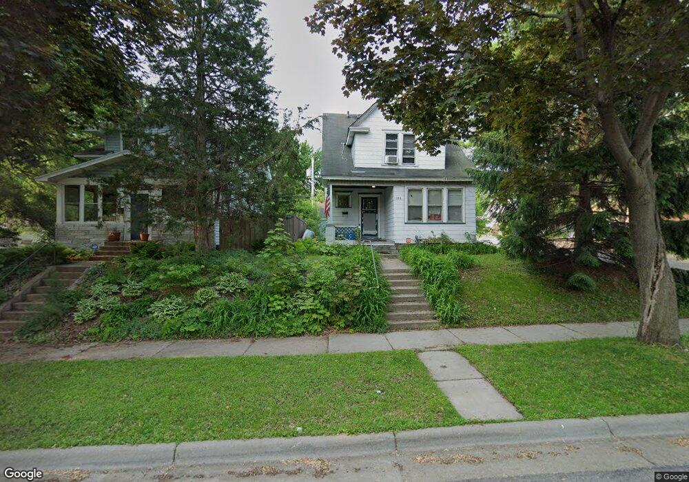
1120 Mclean Ave Saint Paul, MN 55106
Dayton's Bluff NeighborhoodEstimated Value: $213,568 - $246,000
3
Beds
1
Bath
1,281
Sq Ft
$179/Sq Ft
Est. Value
About This Home
This home is located at 1120 Mclean Ave, Saint Paul, MN 55106 and is currently estimated at $229,642, approximately $179 per square foot. 1120 Mclean Ave is a home located in Ramsey County with nearby schools including Dayton's Bluff Achievement Plus Elementary School, Battle Creek Middle School, and Harding Senior High School.
Ownership History
Date
Name
Owned For
Owner Type
Purchase Details
Closed on
Dec 30, 2002
Sold by
Meyers Vincent and Peterson Lara
Bought by
Meyers Deanna and Meyers Terin
Current Estimated Value
Purchase Details
Closed on
Jul 24, 1996
Sold by
Rangitsch Joseph and Rangitsch Patricia
Bought by
Peterson Lara and Meyers Vincent
Purchase Details
Closed on
Oct 19, 1995
Sold by
Us Dept Of Hud
Bought by
Rangitsch Joseph and Rangitsch Patricia
Create a Home Valuation Report for This Property
The Home Valuation Report is an in-depth analysis detailing your home's value as well as a comparison with similar homes in the area
Home Values in the Area
Average Home Value in this Area
Purchase History
| Date | Buyer | Sale Price | Title Company |
|---|---|---|---|
| Meyers Deanna | $141,000 | -- | |
| Peterson Lara | $88,900 | -- | |
| Rangitsch Joseph | $41,570 | -- |
Source: Public Records
Tax History Compared to Growth
Tax History
| Year | Tax Paid | Tax Assessment Tax Assessment Total Assessment is a certain percentage of the fair market value that is determined by local assessors to be the total taxable value of land and additions on the property. | Land | Improvement |
|---|---|---|---|---|
| 2025 | $2,652 | $197,700 | $22,500 | $175,200 |
| 2023 | $2,652 | $169,500 | $14,400 | $155,100 |
| 2022 | $2,334 | $176,100 | $14,400 | $161,700 |
| 2021 | $2,000 | $140,400 | $14,400 | $126,000 |
| 2020 | $2,248 | $124,300 | $14,400 | $109,900 |
| 2019 | $1,634 | $130,800 | $14,400 | $116,400 |
| 2018 | $1,482 | $98,700 | $14,400 | $84,300 |
| 2017 | $1,632 | $95,100 | $14,400 | $80,700 |
| 2016 | $1,626 | $0 | $0 | $0 |
| 2015 | $1,678 | $95,500 | $12,600 | $82,900 |
| 2014 | $1,456 | $0 | $0 | $0 |
Source: Public Records
Map
Nearby Homes
- 1102 Pacific St
- 1005 Mclean Ave
- 1076 Wilson Ave
- 401 Johnson Pkwy
- 1020 Wilson Ave
- 271 English St
- 995 Wakefield Ave
- 1097 Euclid St
- 1257 Wilson Ave
- 1269 Wilson Ave
- 1333 Pacific St
- 244 Point Douglas Rd N
- 1056 3rd St E
- 1320 Wilson Ave
- 980 3rd St E
- 1026 Fremont Ave
- 212 Maple St
- 1363 4th St E
- 530 Forest St
- 1085 Hancock St
- 1124 Mclean Ave
- 1116 Mclean Ave
- 1134 Mclean Ave
- 1134 1134 McLean-avenue-
- 1125 Suburban Ave
- 1138 Mclean Ave
- 1115 Suburban Ave
- 1114 Mclean Ave
- 1133 Suburban Ave
- 1121 Mclean Ave
- 1125 Mclean Ave
- 1113 Suburban Ave
- 1129 Mclean Ave
- 1115 Mclean Ave
- 1139 Suburban Ave
- 1142 Mclean Ave
- 1107 Suburban Ave
- 1133 Mclean Ave
- 1111 Mclean Ave
- 1100 Mclean Ave