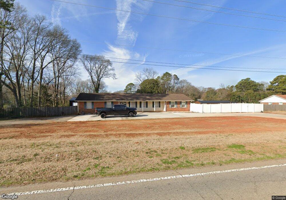
1135 Dobys Bridge Rd Fort Mill, SC 29715
Estimated Value: $461,000 - $489,665
3
Beds
2
Baths
2,091
Sq Ft
$226/Sq Ft
Est. Value
About This Home
This home is located at 1135 Dobys Bridge Rd, Fort Mill, SC 29715 and is currently estimated at $473,416, approximately $226 per square foot. 1135 Dobys Bridge Rd is a home located in York County with nearby schools including Riverview Elementary School, Banks Trail Middle School, and Catawba Ridge High School.
Ownership History
Date
Name
Owned For
Owner Type
Purchase Details
Closed on
Sep 30, 2022
Sold by
Leung Lani S
Bought by
Levassiur Justin W and Levassiur Jocelyn S
Current Estimated Value
Home Financials for this Owner
Home Financials are based on the most recent Mortgage that was taken out on this home.
Original Mortgage
$152,500
Outstanding Balance
$130,376
Interest Rate
4.55%
Mortgage Type
New Conventional
Estimated Equity
$343,040
Purchase Details
Closed on
Dec 22, 2014
Sold by
Voss Rosie
Bought by
Leung Lani S
Home Financials for this Owner
Home Financials are based on the most recent Mortgage that was taken out on this home.
Original Mortgage
$152,000
Interest Rate
4.03%
Mortgage Type
New Conventional
Purchase Details
Closed on
May 16, 2013
Sold by
Voss Rosie Wo
Bought by
Voss Rosie
Create a Home Valuation Report for This Property
The Home Valuation Report is an in-depth analysis detailing your home's value as well as a comparison with similar homes in the area
Home Values in the Area
Average Home Value in this Area
Purchase History
| Date | Buyer | Sale Price | Title Company |
|---|---|---|---|
| Levassiur Justin W | $150,000 | -- | |
| Leung Lani S | $190,000 | -- | |
| Voss Rosie | -- | -- |
Source: Public Records
Mortgage History
| Date | Status | Borrower | Loan Amount |
|---|---|---|---|
| Open | Levassiur Justin W | $152,500 | |
| Previous Owner | Leung Lani S | $152,000 |
Source: Public Records
Tax History Compared to Growth
Tax History
| Year | Tax Paid | Tax Assessment Tax Assessment Total Assessment is a certain percentage of the fair market value that is determined by local assessors to be the total taxable value of land and additions on the property. | Land | Improvement |
|---|---|---|---|---|
| 2024 | $1,967 | $11,812 | $2,400 | $9,412 |
| 2023 | $1,903 | $11,812 | $2,400 | $9,412 |
| 2022 | $4,925 | $11,696 | $3,242 | $8,454 |
| 2021 | -- | $11,696 | $3,242 | $8,454 |
| 2020 | $4,743 | $11,696 | $0 | $0 |
| 2019 | $4,417 | $10,170 | $0 | $0 |
| 2018 | $4,408 | $10,170 | $0 | $0 |
| 2017 | $4,208 | $10,170 | $0 | $0 |
| 2016 | $4,086 | $10,170 | $0 | $0 |
| 2014 | $576 | $9,480 | $2,700 | $6,780 |
| 2013 | $576 | $9,246 | $2,412 | $6,834 |
Source: Public Records
Map
Nearby Homes
- 1177 Doby Ct
- 114 Lazenby Dr
- 1228 N Dobys Bridge Rd
- 820 Pecan Tree Ln
- 947 Pecan Tree Ln
- 206 Coburn Ct
- 925 Cobbled Way
- 2133 Bowie Stone Ct
- 4211 Skyboat Cir
- 147 Morning Gap Pkwy
- 127 Phil Ct Unit 50
- 114 Country Club Dr
- 101 Randolph St
- 103 Mary Louise Ct
- 408 Joe Louis St
- 124 Fordham Ct Unit 19
- Furman Plan at Patterson Pond
- Riverton Plan at Patterson Pond
- Vanderbuilt Plan at Patterson Pond
- Wingate Plan at Patterson Pond