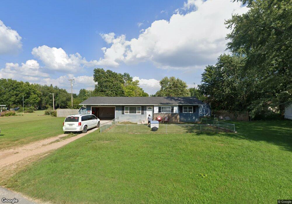
1138 Porter Ave Aurora, MO 65605
Estimated Value: $135,000 - $159,109
3
Beds
2
Baths
1,180
Sq Ft
$128/Sq Ft
Est. Value
About This Home
This home is located at 1138 Porter Ave, Aurora, MO 65605 and is currently estimated at $150,777, approximately $127 per square foot. 1138 Porter Ave is a home located in Lawrence County with nearby schools including Pate Early Childhood Center, Robinson Elementary School, and Robinson Intermediate School.
Ownership History
Date
Name
Owned For
Owner Type
Purchase Details
Closed on
Feb 13, 2014
Sold by
Glessner Carol Sue
Bought by
Erickson Jennifer Dianna
Current Estimated Value
Home Financials for this Owner
Home Financials are based on the most recent Mortgage that was taken out on this home.
Original Mortgage
$65,500
Outstanding Balance
$50,863
Interest Rate
3.75%
Mortgage Type
USDA
Estimated Equity
$99,914
Create a Home Valuation Report for This Property
The Home Valuation Report is an in-depth analysis detailing your home's value as well as a comparison with similar homes in the area
Home Values in the Area
Average Home Value in this Area
Purchase History
| Date | Buyer | Sale Price | Title Company |
|---|---|---|---|
| Erickson Jennifer Dianna | -- | None Available |
Source: Public Records
Mortgage History
| Date | Status | Borrower | Loan Amount |
|---|---|---|---|
| Open | Erickson Jennifer Dianna | $65,500 |
Source: Public Records
Tax History
| Year | Tax Paid | Tax Assessment Tax Assessment Total Assessment is a certain percentage of the fair market value that is determined by local assessors to be the total taxable value of land and additions on the property. | Land | Improvement |
|---|---|---|---|---|
| 2025 | $665 | $13,280 | $2,340 | $10,940 |
| 2024 | $615 | $12,200 | $2,340 | $9,860 |
| 2023 | $612 | $12,200 | $2,340 | $9,860 |
| 2022 | $576 | $11,480 | $2,340 | $9,140 |
| 2021 | $576 | $11,480 | $2,340 | $9,140 |
| 2020 | $540 | $10,660 | $1,520 | $9,140 |
| 2019 | $531 | $10,660 | $1,520 | $9,140 |
| 2018 | $530 | $10,660 | $1,520 | $9,140 |
| 2017 | $528 | $10,660 | $1,520 | $9,140 |
| 2016 | -- | $9,770 | $1,520 | $8,250 |
| 2015 | -- | $9,770 | $1,520 | $8,250 |
| 2014 | -- | $9,770 | $1,520 | $8,250 |
Source: Public Records
Map
Nearby Homes
- 1015 Mcphail Ave
- 723 E Walnut St
- 905 S Griffith Ave
- 808 E Walnut St
- 516 E Springfield St
- 806 E Springfield St
- 000 E Glendale St
- 1622 S Porter Ave
- 601 E Highland St
- 825 S Park Ave
- 116 E Hadley St
- 317 E Highland St
- 1305 S Jefferson Ave
- 537 S Jefferson Ave
- 312 S Oak Ave
- 33 W Street Louis St
- 114 E College St
- 23 W Anderson St
- 220 S Park Ave
- 216 S Elliott Ave
- 1138 S Porter Ave Unit 1309535
- 1138 S Porter Ave
- 1045 Carol Ct
- 1140 Porter Ave
- 1140 S Porter Ave
- 1136 Porter Ave
- 707 Carol Ct
- 1137 Porter Ave
- 1103 Carol Ct
- 1139 S Porter Ave
- 1139 Porter Ave
- 1135 Porter Ave
- 1141 Porter Ave
- 1041 S Hudson Ave
- 1142 Porter Ave
- 1107 Carol Ct
- 1145 S Porter Ave
- 1145 Porter Ave
- 1041 1/2 S Hudson Ave
- 1043 S Hudson Ave
Your Personal Tour Guide
Ask me questions while you tour the home.