Estimated Value: $406,183 - $601,000
3
Beds
3
Baths
2,086
Sq Ft
$224/Sq Ft
Est. Value
About This Home
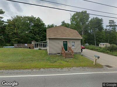
This home is located at 114 Frank C Gilman Hwy, Alton, NH 03809 and is currently estimated at $467,796, approximately $224 per square foot. 114 Frank C Gilman Hwy is a home located in Belknap County with nearby schools including Alton Central School (Elem) and Prospect Mountain High School.
Ownership History
Date
Name
Owned For
Owner Type
Purchase Details
Closed on
Jul 5, 2001
Sold by
Huckins Michael G and Huckins Jennifer A
Bought by
Argiropolis John G and Argiropolis Krista
Current Estimated Value
Home Financials for this Owner
Home Financials are based on the most recent Mortgage that was taken out on this home.
Original Mortgage
$124,450
Interest Rate
7.21%
Create a Home Valuation Report for This Property
The Home Valuation Report is an in-depth analysis detailing your home's value as well as a comparison with similar homes in the area
Home Values in the Area
Average Home Value in this Area
Purchase History
| Date | Buyer | Sale Price | Title Company |
|---|---|---|---|
| Argiropolis John G | $131,000 | -- |
Source: Public Records
Mortgage History
| Date | Status | Borrower | Loan Amount |
|---|---|---|---|
| Open | Argiropolis John G | $162,800 | |
| Closed | Argiropolis John G | $95,200 | |
| Closed | Argiropolis John G | $58,000 | |
| Closed | Argiropolis John G | $39,945 | |
| Closed | Argiropolis John G | $124,450 |
Source: Public Records
Tax History Compared to Growth
Tax History
| Year | Tax Paid | Tax Assessment Tax Assessment Total Assessment is a certain percentage of the fair market value that is determined by local assessors to be the total taxable value of land and additions on the property. | Land | Improvement |
|---|---|---|---|---|
| 2024 | $2,784 | $214,500 | $58,200 | $156,300 |
| 2022 | $2,439 | $214,500 | $58,200 | $156,300 |
| 2021 | $2,441 | $214,500 | $58,200 | $156,300 |
| 2020 | $5,685 | $193,200 | $55,100 | $138,100 |
| 2019 | $2,467 | $197,200 | $55,100 | $142,100 |
| 2018 | $2,759 | $197,200 | $55,100 | $142,100 |
| 2017 | $5,838 | $197,200 | $55,100 | $142,100 |
| 2016 | $5,505 | $162,100 | $43,100 | $119,000 |
| 2015 | $2,313 | $162,100 | $43,100 | $119,000 |
| 2014 | $2,263 | $163,400 | $39,600 | $123,800 |
| 2013 | $2,074 | $154,300 | $30,500 | $123,800 |
Source: Public Records
Map
Nearby Homes
- 21 Silver Cascade Way
- 119 Main St
- 247 Main St
- 29 Main St
- 140 Fox Trot Loop
- 6 Suncook Valley Rd
- 11C-2 New Hampshire 140
- Lot 11C-1 New Hampshire 140
- 00 Route 11 & New Durham Rd Unit 57
- 22 Courtyard Cir
- 115 Mount Major Hwy
- 53 Eagles Way
- 51 Eagles Way
- 349 Halls Hill Rd
- 190 Mount Major Hwy
- 122 Chickadee Ln
- 499 Heron Point Rd
- 14 Dan Kelley Dr
- 18 Donald Dr Unit 27
- 291 Mount Major Hwy
- 114 Frank C Gilman Hwy
- 122 Frank C Gilman Hwy
- 7 Elliot Rd
- 109 Frank C Gilman Hwy
- 4 Elliot Rd
- 119 Frank C Gilman Hwy
- 99 Frank C Gilman Hwy
- 11 Elliot Rd
- 129 Frank C Gilman Hwy
- 128 Frank C Gilman Hwy
- 18 Elliot Rd
- 20 Elliot Rd
- 140 Frank C Gilman Hwy
- 5 Riverside Dr
- 7 Riverside Dr
- 132 Frank C Gilman Hwy
- 25 Elliot Rd
- 32 Elliot Rd
- 23 Riverside Dr
- 149 Frank C Gilman Hwy