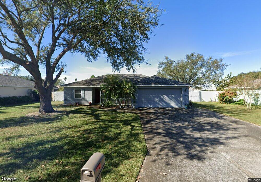
115 Mohawk Cir Auburndale, FL 33823
Estimated Value: $255,485 - $274,000
3
Beds
2
Baths
1,216
Sq Ft
$218/Sq Ft
Est. Value
About This Home
This home is located at 115 Mohawk Cir, Auburndale, FL 33823 and is currently estimated at $265,121, approximately $218 per square foot. 115 Mohawk Cir is a home located in Polk County with nearby schools including Walter Caldwell Elementary School, Auburndale Senior High School, and Jewett School of the Arts.
Ownership History
Date
Name
Owned For
Owner Type
Purchase Details
Closed on
Jun 10, 2021
Sold by
Valletutti Sandra N and Valletutti Sandra G
Bought by
Johnson Gary F and Murray Shawn
Current Estimated Value
Purchase Details
Closed on
Nov 30, 2000
Sold by
Hall Earl D and Hall Michelle D
Bought by
Valletutti Sandra N
Home Financials for this Owner
Home Financials are based on the most recent Mortgage that was taken out on this home.
Original Mortgage
$20,000
Interest Rate
7.82%
Mortgage Type
Credit Line Revolving
Purchase Details
Closed on
Jun 20, 1996
Sold by
Signature Homes Of Central Florida In
Bought by
Hall Earl D and Hall Michelle D
Home Financials for this Owner
Home Financials are based on the most recent Mortgage that was taken out on this home.
Original Mortgage
$3,000
Interest Rate
8.21%
Create a Home Valuation Report for This Property
The Home Valuation Report is an in-depth analysis detailing your home's value as well as a comparison with similar homes in the area
Home Values in the Area
Average Home Value in this Area
Purchase History
| Date | Buyer | Sale Price | Title Company |
|---|---|---|---|
| Johnson Gary F | -- | Accommodation | |
| Valletutti Sandra N | $84,000 | -- | |
| Hall Earl D | $12,500 | -- |
Source: Public Records
Mortgage History
| Date | Status | Borrower | Loan Amount |
|---|---|---|---|
| Previous Owner | Hall Earl D | $40,410 | |
| Previous Owner | Hall Earl D | $20,000 | |
| Previous Owner | Hall Earl D | $3,000 |
Source: Public Records
Tax History
| Year | Tax Paid | Tax Assessment Tax Assessment Total Assessment is a certain percentage of the fair market value that is determined by local assessors to be the total taxable value of land and additions on the property. | Land | Improvement |
|---|---|---|---|---|
| 2025 | $502 | $69,410 | -- | -- |
| 2024 | $498 | $67,454 | -- | -- |
| 2023 | $498 | $65,489 | $0 | $0 |
| 2022 | $492 | $63,582 | $0 | $0 |
| 2021 | $499 | $61,730 | $0 | $0 |
| 2020 | $498 | $60,878 | $0 | $0 |
| 2018 | $501 | $58,399 | $0 | $0 |
| 2017 | $494 | $57,198 | $0 | $0 |
| 2016 | $495 | $56,022 | $0 | $0 |
Source: Public Records
Map
Nearby Homes
- 144 Costa Loop
- 159 Auburn Grove Blvd
- 163 Auburn Grove Blvd
- 122 Costa Loop
- 214 Eagle Point Loop
- 1122 Oak Valley Dr
- 506 Auburn Grove Terrace
- 113 Costa Loop
- 506 Alleria Ct
- 132 Magneta Loop
- 412 Diamond Ridge Dr
- 130 Bergen Cir
- 168 Magneta Loop
- 714 Auburn Grove Ct
- 178 Magneta Loop
- 1830 Van Allen Loop
- 1643 Bark Ridge Dr
- 1646 Bark Ridge Dr
- 452 Palastro Ave
- 114 Bergen Cir
- 113 Mohawk Cir
- 117 Mohawk Cir
- 108 Cherokee Dr
- 106 Cherokee Dr
- 108 Mohawk Cir
- 110 Cherokee Dr
- 106 Mohawk Cir
- 104 Cherokee Dr
- 111 Mohawk Cir
- 119 Mohawk Cir
- 112 Cherokee Dr
- 102 Cherokee Dr
- 110 Mohawk Cir
- 104 Mohawk Cir
- 121 Mohawk Cir
- 109 Mohawk Cir
- 114 Cherokee Dr
- 107 Mohawk Cir
- 123 Mohawk Cir
- 510 Adams Rd
Your Personal Tour Guide
Ask me questions while you tour the home.