M
Seller's Agent in 2025
Meg Grotting
RE/MAX
(530) 209-6049
3 in this area
86 Total Sales

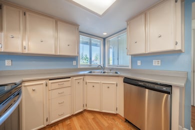
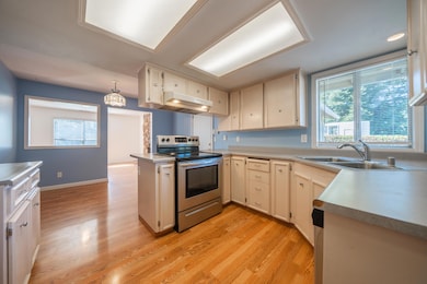
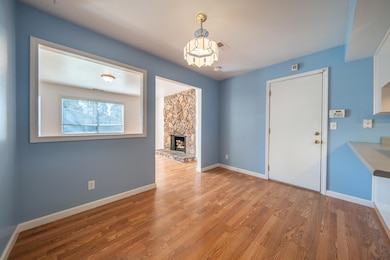
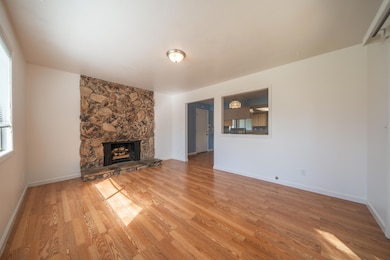
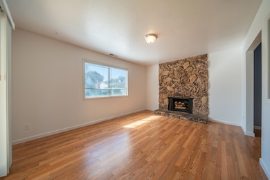
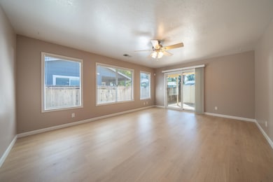
Open House Saturday 11/8 11-1. Welcome to this beautifully updated 3-bedroom, 2-bath home offering 1,371 square feet of comfortable living space. This move-in ready home features new flooring throughout, updated bathrooms, and both a living and family room—perfect for entertaining or relaxing. Enjoy cozy evenings by the fireplace as well as energy savings all year long with owned solar. The property also includes a 2-car garage, providing ample parking and storage. Out back you will find one of the larger lots in the neighborhood with lots of room to add a pool or raised garden beds, there are even 2 sheds out back. This home is a wonderful blend of modern upgrades and everyday comfort—this home has it all!
Last Agent to Sell the Property
RE/MAX Five Star License #01220888 Listed on: 10/07/2025

| Date | Type | Sale Price | Title Company |
|---|---|---|---|
| Grant Deed | $345,000 | Placer Title | |
| Deed | -- | None Listed On Document | |
| Grant Deed | $244,000 | First American Title Co | |
| Grant Deed | $89,000 | First American Title Co |
| Date | Status | Loan Amount | Loan Type |
|---|---|---|---|
| Open | $12,075 | FHA | |
| Open | $338,751 | FHA | |
| Previous Owner | $91,670 | VA |
| Date | Event | Price | List to Sale | Price per Sq Ft |
|---|---|---|---|---|
| 12/29/2025 12/29/25 | Sold | $345,000 | 0.0% | $252 / Sq Ft |
| 12/02/2025 12/02/25 | Pending | -- | -- | -- |
| 10/28/2025 10/28/25 | Price Changed | $345,000 | -2.8% | $252 / Sq Ft |
| 10/07/2025 10/07/25 | For Sale | $355,000 | -- | $259 / Sq Ft |
| Year | Tax Paid | Tax Assessment Tax Assessment Total Assessment is a certain percentage of the fair market value that is determined by local assessors to be the total taxable value of land and additions on the property. | Land | Improvement |
|---|---|---|---|---|
| 2025 | $3,658 | $344,298 | $118,474 | $225,824 |
| 2024 | $3,634 | $337,598 | $116,151 | $221,447 |
| 2023 | $3,634 | $333,568 | $113,874 | $219,694 |
| 2022 | $3,245 | $300,842 | $60,000 | $240,842 |
| 2021 | $2,668 | $251,700 | $50,000 | $201,700 |
| 2020 | $2,430 | $228,230 | $45,000 | $183,230 |
| 2019 | $2,345 | $217,953 | $45,000 | $172,953 |
| 2018 | $1,975 | $182,700 | $42,000 | $140,700 |
| 2017 | $1,973 | $176,090 | $40,000 | $136,090 |
| 2016 | $1,841 | $172,340 | $35,000 | $137,340 |
| 2015 | $1,640 | $153,000 | $30,000 | $123,000 |
| 2014 | $1,549 | $143,000 | $30,000 | $113,000 |
M
Seller's Agent in 2025
Meg Grotting
RE/MAX
(530) 209-6049
3 in this area
86 Total Sales
Seller Co-Listing Agent in 2025
Chrissy Grotting
RE/MAX
(530) 209-9545
4 in this area
99 Total Sales
C
Buyer's Agent in 2025
Chase Laws
Real Brokerage Technologies
(619) 248-6434
2 in this area
26 Total Sales
Source: Shasta Association of REALTORS®
MLS Number: 25-4503
APN: 068-520-021-000
Disclaimer: Certain information contained herein is derived from information provided by parties other than Homes.com. All information provided is deemed reliable, but is not guaranteed to be accurate and should be independently verified.
![]() IDX information is provided exclusively for personal, non-commercial use, and may not be used for any purpose other than to identify prospective properties consumers may be interested in purchasing. Information is deemed reliable but not guaranteed.
IDX information is provided exclusively for personal, non-commercial use, and may not be used for any purpose other than to identify prospective properties consumers may be interested in purchasing. Information is deemed reliable but not guaranteed.
Ask me questions while you tour the home.