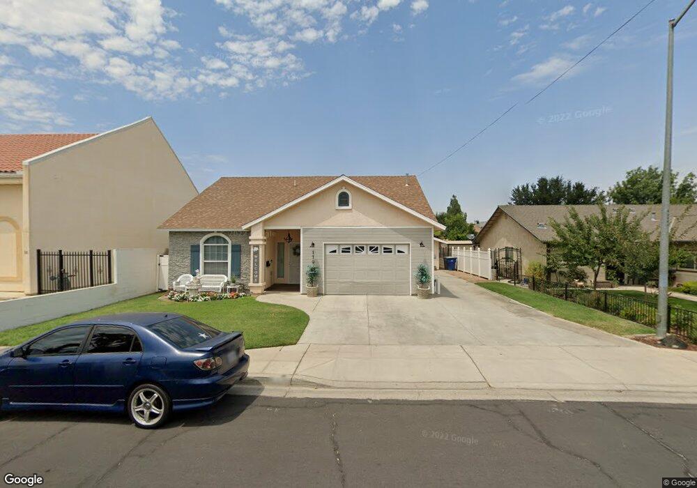
119 5th St Clovis, CA 93612
Estimated Value: $394,965 - $494,000
3
Beds
2
Baths
1,689
Sq Ft
$254/Sq Ft
Est. Value
About This Home
This home is located at 119 5th St, Clovis, CA 93612 and is currently estimated at $428,988, approximately $253 per square foot. 119 5th St is a home located in Fresno County with nearby schools including Weldon Elementary School, Clark Intermediate School, and Clovis High School.
Ownership History
Date
Name
Owned For
Owner Type
Purchase Details
Closed on
Sep 9, 2008
Sold by
Newsom Linda
Bought by
Newson Linda
Current Estimated Value
Home Financials for this Owner
Home Financials are based on the most recent Mortgage that was taken out on this home.
Original Mortgage
$90,000
Outstanding Balance
$59,834
Interest Rate
6.51%
Mortgage Type
New Conventional
Estimated Equity
$369,154
Purchase Details
Closed on
May 7, 2008
Sold by
Newsom Linda
Bought by
Newsom Linda
Purchase Details
Closed on
Dec 6, 2001
Sold by
Dunn Georgia May
Bought by
Dunn Henry M and Dunn Georgia M
Create a Home Valuation Report for This Property
The Home Valuation Report is an in-depth analysis detailing your home's value as well as a comparison with similar homes in the area
Home Values in the Area
Average Home Value in this Area
Purchase History
| Date | Buyer | Sale Price | Title Company |
|---|---|---|---|
| Newson Linda | -- | Placer Title Company | |
| Newsom Linda | -- | None Available | |
| Dunn Henry M | -- | -- |
Source: Public Records
Mortgage History
| Date | Status | Borrower | Loan Amount |
|---|---|---|---|
| Open | Newson Linda | $90,000 |
Source: Public Records
Tax History
| Year | Tax Paid | Tax Assessment Tax Assessment Total Assessment is a certain percentage of the fair market value that is determined by local assessors to be the total taxable value of land and additions on the property. | Land | Improvement |
|---|---|---|---|---|
| 2025 | $2,106 | $176,783 | $6,178 | $170,605 |
| 2023 | $2,027 | $169,920 | $5,939 | $163,981 |
| 2022 | $2,000 | $166,589 | $5,823 | $160,766 |
| 2021 | $1,945 | $163,323 | $5,709 | $157,614 |
| 2020 | $1,937 | $161,649 | $5,651 | $155,998 |
| 2019 | $1,900 | $158,481 | $5,541 | $152,940 |
| 2018 | $1,859 | $155,375 | $5,433 | $149,942 |
| 2017 | $1,827 | $152,329 | $5,327 | $147,002 |
| 2016 | $1,766 | $149,343 | $5,223 | $144,120 |
| 2015 | $1,739 | $147,101 | $5,145 | $141,956 |
| 2014 | $1,708 | $144,221 | $5,045 | $139,176 |
Source: Public Records
Map
Nearby Homes
- 127 5th St
- 142 9th St
- 103 Poppy Ln
- 1234 No Address Available
- 134 10th St
- 474 W Windsor Ave
- 1001 Sylmar Ave Unit 3
- 1001 Sylmar Ave Unit 131
- 1001 Sylmar Ave Unit 99
- 1001 Sylmar Ave Unit 100
- 1001 Sylmar Ave Unit 126
- 1001 Sylmar Ave Unit 155
- 1001 Sylmar Ave
- 345 Sylmar Ave
- 1465 Mayflower Way
- 69 W Beverly Ave Unit 101
- 560 W Stuart Ave
- 1416 Plymouth Rock Way
- 1272 Villa Ave Unit 69
- 1272 Villa Ave Unit 76
- 448 Cherry Ln
- 135 5th St
- 445 Cherry Ln
- 124 5th St
- 145 5th St
- 147 5th St
- 136 5th St
- 491 Minnewawa Ave Unit 101
- 431 Cherry Ln
- 142 5th St
- 460 Oxford Ave
- 481 Minnewawa Ave Unit 104
- 472 Oxford Ave
- 423 Cherry Ln
- 444 Oxford Ave
- 152 5th St
- 575 Minnewawa Ave
- 461 Minnewawa Ave Unit 103
- 461 Minnewawa Ave Unit 101
- 430 Oxford Ave
Your Personal Tour Guide
Ask me questions while you tour the home.