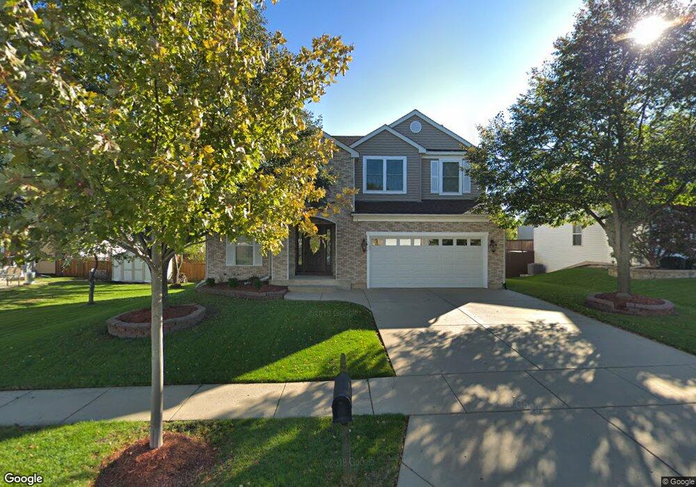
119 Cedarfield Dr Bartlett, IL 60103
Estimated Value: $477,627 - $504,000
4
Beds
3
Baths
2,183
Sq Ft
$223/Sq Ft
Est. Value
About This Home
This home is located at 119 Cedarfield Dr, Bartlett, IL 60103 and is currently estimated at $487,157, approximately $223 per square foot. 119 Cedarfield Dr is a home located in Cook County with nearby schools including Nature Ridge Elementary School, Kenyon Woods Middle School, and South Elgin High School.
Ownership History
Date
Name
Owned For
Owner Type
Purchase Details
Closed on
Mar 5, 2024
Sold by
Mazurek Kenneth L and Mazurek Dianne P
Bought by
Chicago Title Land Trust
Current Estimated Value
Purchase Details
Closed on
Aug 4, 1998
Sold by
Centex Homes
Bought by
Mazurek Kenneth L and Mazurek Dianne P
Home Financials for this Owner
Home Financials are based on the most recent Mortgage that was taken out on this home.
Original Mortgage
$149,693
Interest Rate
7.02%
Create a Home Valuation Report for This Property
The Home Valuation Report is an in-depth analysis detailing your home's value as well as a comparison with similar homes in the area
Home Values in the Area
Average Home Value in this Area
Purchase History
| Date | Buyer | Sale Price | Title Company |
|---|---|---|---|
| Chicago Title Land Trust | -- | Chicago Title | |
| Mazurek Kenneth L | $225,000 | -- |
Source: Public Records
Mortgage History
| Date | Status | Borrower | Loan Amount |
|---|---|---|---|
| Previous Owner | Mazurek Kenneth L | $149,693 |
Source: Public Records
Tax History Compared to Growth
Tax History
| Year | Tax Paid | Tax Assessment Tax Assessment Total Assessment is a certain percentage of the fair market value that is determined by local assessors to be the total taxable value of land and additions on the property. | Land | Improvement |
|---|---|---|---|---|
| 2025 | $9,144 | $44,000 | $7,475 | $36,525 |
| 2024 | $9,144 | $35,000 | $6,354 | $28,646 |
| 2023 | $8,778 | $35,000 | $6,354 | $28,646 |
| 2022 | $8,778 | $35,000 | $6,354 | $28,646 |
| 2021 | $6,528 | $28,405 | $5,606 | $22,799 |
| 2020 | $5,991 | $28,405 | $5,606 | $22,799 |
| 2019 | $5,905 | $31,562 | $5,606 | $25,956 |
| 2018 | $6,206 | $24,592 | $4,858 | $19,734 |
| 2017 | $6,145 | $24,592 | $4,858 | $19,734 |
| 2016 | $6,968 | $25,836 | $4,858 | $20,978 |
| 2015 | $6,488 | $23,159 | $4,298 | $18,861 |
| 2014 | $6,441 | $23,159 | $4,298 | $18,861 |
| 2013 | $6,146 | $23,159 | $4,298 | $18,861 |
Source: Public Records
Map
Nearby Homes
- 1969 Osprey Ct Unit 223
- 180 Primrose Ln Unit 1
- 240 Hearthstone Dr
- 171 Silbury Dr
- 200 Patrick Dr
- 1458 Deer Pointe Dr
- 1474 Deer Pointe Dr
- 6N879 Dunham Rd
- 945 Wyndham Dr
- 629 Dogleg Ln
- 1644 Raymond St
- 653 Elgin Ave
- 1316 Foxglove Dr
- 1318 Foxglove Dr
- 1314 Foxglove Dr
- 303 Ann St
- 1390 Wild Tulip Cir
- 300 N South Elgin Blvd
- 1017 Atterberg Rd
- 1015 Atterberg Rd
- 123 Cedarfield Dr
- 1995 Woodhaven Dr
- 1991 Woodhaven Dr
- 116 Troutman Dr
- 120 Troutman Dr
- 127 Cedarfield Dr
- 1987 Woodhaven Dr
- 118 Cedarfield Dr
- 2003 Woodhaven Dr
- 124 Troutman Dr
- 122 Cedarfield Dr
- 131 Cedarfield Dr
- 126 Cedarfield Dr
- 128 Troutman Dr
- 2007 Woodhaven Dr
- 1992 Woodhaven Dr
- 1996 Woodhaven Dr
- 135 Cedarfield Dr
- 130 Cedarfield Dr
- 2000 Woodhaven Dr