12 ACRES # 2 Wolfpack (No Address) Trail Mayer, AZ 86333
Mayer NeighborhoodEstimated payment $844/month
Highlights
- City Lights View
- No HOA
- Lot Has A Rolling Slope
- 12.01 Acre Lot
- Property is near a preserve or public land
About This Lot
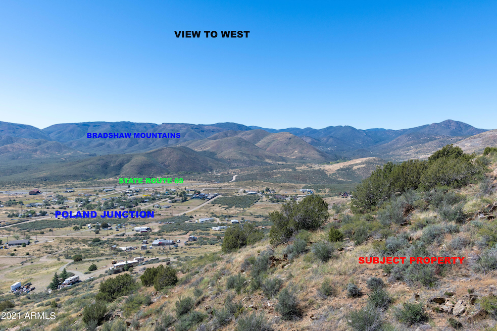
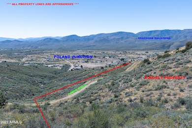
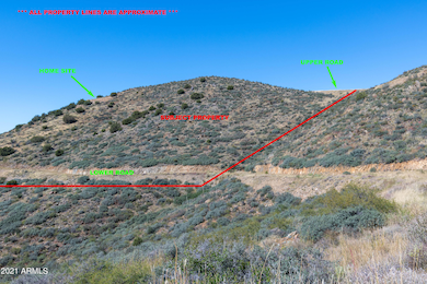
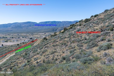
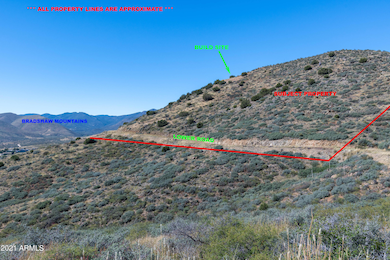
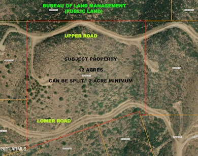
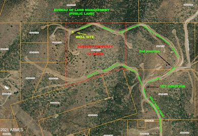
UNBELIEVABLE VIEWS (AS IN JAW DROPPING) FROM THIS PROPERTY. VIEWS OF THE BRADSHAWS ON ONE SIDE, AND MINGUS MTN ON THE OTHER, AND ALL OF DEWEY HUMBOLDT. PROPERTY BORDERS PUBLIC LAND ON THE NORTH (BLM). WOULD BE EXCELLENT PROPERTY FOR OFF GRID HOMES, ELECTRIC FROM SOLAR AND/OR WIND TURBINES. PROPERTY HAS 1000' DEEP WELL THAT CAN BE SET UP AS SHARED WELL WITH ANY SPLITS. MORE INFO AND PHOTOS SOON!
Property Details
Property Type
- Land
Est. Annual Taxes
- $690
Lot Details
- 12.01 Acre Lot
- Lot Has A Rolling Slope
- Property is zoned RCU-2A
Property Views
- City Lights
- Mountain
Utilities
- Well
Community Details
- No Home Owners Association
- Property is near a preserve or public land
Listing and Financial Details
- Assessor Parcel Number 500-09-167-G
Map
Home Values in the Area
Average Home Value in this Area
Property History
| Date | Event | Price | List to Sale | Price per Sq Ft |
|---|---|---|---|---|
| 08/04/2025 08/04/25 | Price Changed | $148,900 | -0.7% | -- |
| 10/05/2024 10/05/24 | For Sale | $149,900 | 0.0% | -- |
| 10/05/2024 10/05/24 | Off Market | $149,900 | -- | -- |
| 11/14/2022 11/14/22 | Price Changed | $149,900 | -16.7% | -- |
| 10/06/2021 10/06/21 | For Sale | $179,900 | -- | -- |
Source: Arizona Regional Multiple Listing Service (ARMLS)
MLS Number: 6304156
Disclaimer: Certain information contained herein is derived from information provided by parties other than Homes.com. All information provided is deemed reliable, but is not guaranteed to be accurate and should be independently verified.
![]() All information should be verified by the recipient and none is guaranteed as accurate by ARMLS
All information should be verified by the recipient and none is guaranteed as accurate by ARMLS
Listing Information presented by local MLS brokerage: Ten-X, local REALTOR®- Arlene Richardson - (888)-952-6393
- 12 ACRES # 2 Wolfpack (No Address) Trail
- 6117 S Country Rd
- 0 S Wolf Pack Trail
- 6308 S Wolf Pack Trail Unit 500-09-149B
- 11830 E Meadow Dr Unit C
- 6862 S State Route 69
- 0 Thoroughbred Branding Iron Unit 1037684
- 12055 E Branding Iron Way
- 5720 Miners Pick Rd Unit 3
- 5720 Miners Pick Rd
- 0 E Bright Moons Way Unit PAR1076490
- 0j Bullhorn
- 0 E Bright Moons Way Unit 5
- 7925 S Lone Spruce Dr
- 0 E Pearl Mountain Rd Unit PAR1065556
- 0 E Poland Rd Unit PAR1076644
- 0000 Arizona 69
- 20 ACRES S Elizabeth Mine Rd
- 0 E Winding View Dr Unit PAR1076617
- 13260 E Sacred River Ln
- 12900 E State Route 169
- 320 S Hoss Rd
- 175 N Village Way Unit 61
- 175 N Village Way Unit 65
- 12351 E Bradshaw Mountain Rd
- 11900 E Powderhorn Pass
- 679 N Blanco Ct
- 1299 N Tapadero Dr Unit D
- 10676 E Singletree Trail
- 7239 E Barefoot Ln
- 1915 N Bittersweet Way
- 2976 N Yavapai Rd E Unit 2
- 3101 N Corrine Dr Unit 1
- 8683 E Commons Cir Unit 203
- 8683 E Commons Cir Unit A313
- 8683 E Commons Cir Unit 102
- 17270 E Peach Tree Rd
- 3325 E Yavapai Rd Unit B
- 8860 E Yavapai Rd Unit C
- 3184 N Tani Rd
