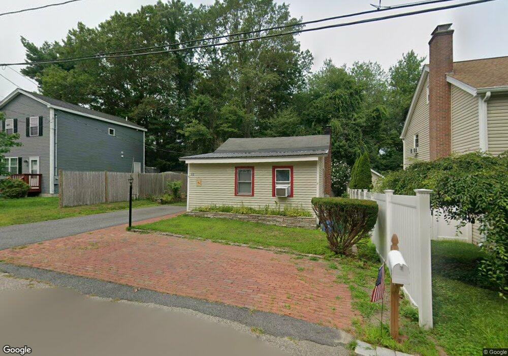
12 Columbine Rd Mansfield, MA 02048
Estimated Value: $306,000 - $426,000
2
Beds
1
Bath
740
Sq Ft
$501/Sq Ft
Est. Value
About This Home
This home is located at 12 Columbine Rd, Mansfield, MA 02048 and is currently estimated at $371,055, approximately $501 per square foot. 12 Columbine Rd is a home located in Bristol County with nearby schools including Everett W. Robinson Elementary School, Jordan/Jackson Elementary School, and Harold L. Qualters Middle School.
Ownership History
Date
Name
Owned For
Owner Type
Purchase Details
Closed on
Apr 11, 1984
Bought by
Thomas Raymond A and Blaisdell Barbara J
Current Estimated Value
Create a Home Valuation Report for This Property
The Home Valuation Report is an in-depth analysis detailing your home's value as well as a comparison with similar homes in the area
Home Values in the Area
Average Home Value in this Area
Purchase History
| Date | Buyer | Sale Price | Title Company |
|---|---|---|---|
| Thomas Raymond A | $44,500 | -- |
Source: Public Records
Mortgage History
| Date | Status | Borrower | Loan Amount |
|---|---|---|---|
| Open | Thomas Raymond A | $74,066 |
Source: Public Records
Tax History Compared to Growth
Tax History
| Year | Tax Paid | Tax Assessment Tax Assessment Total Assessment is a certain percentage of the fair market value that is determined by local assessors to be the total taxable value of land and additions on the property. | Land | Improvement |
|---|---|---|---|---|
| 2025 | $3,665 | $278,300 | $136,100 | $142,200 |
| 2024 | $3,401 | $251,900 | $136,100 | $115,800 |
| 2023 | $3,338 | $236,900 | $136,100 | $100,800 |
| 2022 | $3,237 | $213,400 | $126,000 | $87,400 |
| 2021 | $3,482 | $226,700 | $131,300 | $95,400 |
| 2020 | $3,438 | $223,800 | $131,300 | $92,500 |
| 2019 | $3,062 | $201,200 | $103,900 | $97,300 |
| 2018 | $2,765 | $179,500 | $93,800 | $85,700 |
| 2017 | $2,725 | $181,400 | $90,900 | $90,500 |
| 2016 | $2,644 | $171,600 | $76,900 | $94,700 |
| 2015 | $2,416 | $155,900 | $76,900 | $79,000 |
Source: Public Records
Map
Nearby Homes
- 18 Columbine Rd
- 15 Reservoir St Unit 44
- 21 Juniper Rd
- 39 Evergreen Rd
- 250 Mansfield Ave Unit 66
- 268 Reservoir St
- 15 Patten Rd
- 12 Sylvan Rd
- 0 Brook Pkwy
- 157 Mansfield Ave Unit 14
- 711 Ware St
- 10 Ridge Rd
- 778 Ware St
- 23 Indian Rd
- 460 Ware St
- 442 Ware St
- 414 Branch St
- 93 Mansfield Ave
- 0 Kensington Rd
- 18 Millfarm Dr
- 10 Columbine Rd
- 14 Columbine Rd
- 15 Columbine Rd
- 30 Thornton Rd
- 20 Thornton Rd
- 4 Columbine Rd
- 1 Columbine Rd
- 10 Thornton Rd
- 80 Reservoir St
- 72 Reservoir St
- 66 Thornton Rd
- 34 Thornton Rd
- 443 Reservoir St
- 441 Reservoir St
- 1 Thornton Rd
- 14 Barberry Rd
- 27 Columbine Rd
- 10 Barberry Rd
- 27 Thornton Rd
- 2 Barberry Rd