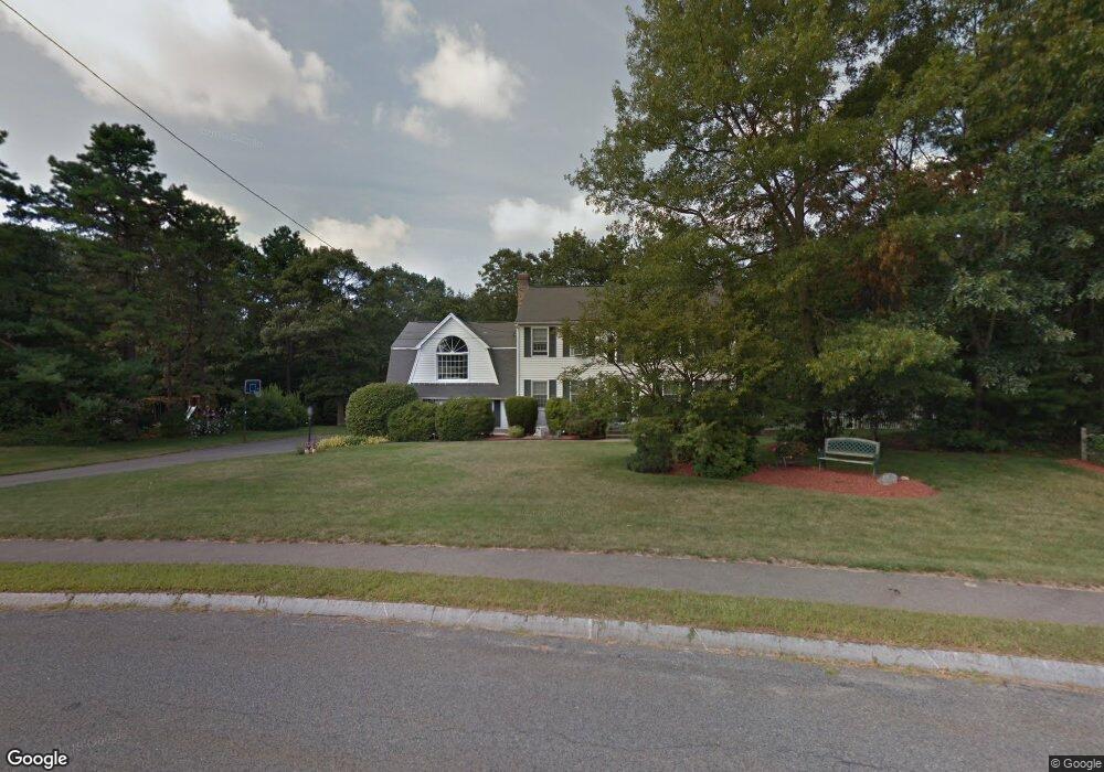
12 Marthas Way Franklin, MA 02038
Estimated Value: $766,000 - $935,000
3
Beds
3
Baths
2,480
Sq Ft
$343/Sq Ft
Est. Value
About This Home
This home is located at 12 Marthas Way, Franklin, MA 02038 and is currently estimated at $849,970, approximately $342 per square foot. 12 Marthas Way is a home located in Norfolk County with nearby schools including Helen Keller Elementary School, Annie Sullivan Middle School, and Franklin High School.
Ownership History
Date
Name
Owned For
Owner Type
Purchase Details
Closed on
Oct 18, 1993
Sold by
Marianne Bldg Corp
Bought by
Donovan Robert M and Donovan Sharon T
Current Estimated Value
Create a Home Valuation Report for This Property
The Home Valuation Report is an in-depth analysis detailing your home's value as well as a comparison with similar homes in the area
Home Values in the Area
Average Home Value in this Area
Purchase History
| Date | Buyer | Sale Price | Title Company |
|---|---|---|---|
| Donovan Robert M | $195,900 | -- |
Source: Public Records
Mortgage History
| Date | Status | Borrower | Loan Amount |
|---|---|---|---|
| Open | Donovan Robert M | $224,350 | |
| Closed | Donovan Robert M | $38,500 | |
| Closed | Donovan Robert M | $19,300 |
Source: Public Records
Tax History Compared to Growth
Tax History
| Year | Tax Paid | Tax Assessment Tax Assessment Total Assessment is a certain percentage of the fair market value that is determined by local assessors to be the total taxable value of land and additions on the property. | Land | Improvement |
|---|---|---|---|---|
| 2025 | $8,121 | $698,900 | $331,800 | $367,100 |
| 2024 | $8,082 | $685,500 | $331,800 | $353,700 |
| 2023 | $7,797 | $619,800 | $282,800 | $337,000 |
| 2022 | $7,307 | $520,100 | $222,700 | $297,400 |
| 2021 | $7,382 | $503,900 | $250,000 | $253,900 |
| 2020 | $6,984 | $481,300 | $239,800 | $241,500 |
| 2019 | $6,905 | $471,000 | $229,500 | $241,500 |
| 2018 | $6,418 | $438,100 | $221,300 | $216,800 |
| 2017 | $6,148 | $421,700 | $204,900 | $216,800 |
| 2016 | $6,342 | $437,400 | $219,800 | $217,600 |
| 2015 | $6,328 | $426,400 | $208,800 | $217,600 |
| 2014 | $5,792 | $400,800 | $183,200 | $217,600 |
Source: Public Records
Map
Nearby Homes
- 324 Pleasant St
- 266 Pleasant St
- 11 Elliot Mills Unit 11
- 150 Pleasant St
- 12 Waites Crossing Way
- 48 Pinehurst St
- 67 Milliken Ave Unit 22
- 204 Lincoln St
- 17 Longhill Rd
- 11 Waites Crossing
- 20 Waites Crossing
- 19 Waites Crossing
- 9 Waites Crossing
- 13 Waites Crossing
- 76 Dean Ave
- 1 Uncas Ave
- 159 E Central St
- 33 Daniels St
- 37 Daniels St
- 14 Pleasant St Unit A