Estimated Value: $232,000 - $263,000
3
Beds
3
Baths
2,106
Sq Ft
$119/Sq Ft
Est. Value
About This Home
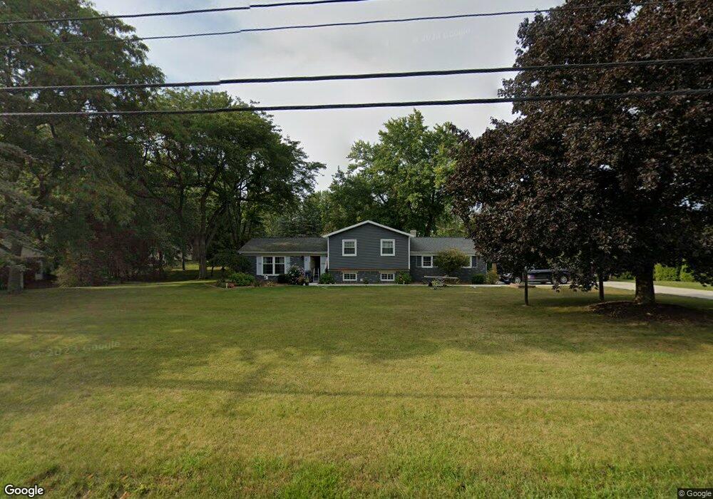
This home is located at 12082 State Route 34, Bryan, OH 43506 and is currently estimated at $250,099, approximately $118 per square foot. 12082 State Route 34 is a home located in Williams County with nearby schools including Bryan Elementary PK-5, Washington Elementary School, and Bryan Middle School/High School.
Ownership History
Date
Name
Owned For
Owner Type
Purchase Details
Closed on
Jul 29, 2013
Sold by
Fisher Roxanne L
Bought by
Lupo Benjamin David and Lupo Marissa Kay
Current Estimated Value
Home Financials for this Owner
Home Financials are based on the most recent Mortgage that was taken out on this home.
Original Mortgage
$120,000
Outstanding Balance
$88,224
Interest Rate
4.49%
Mortgage Type
New Conventional
Estimated Equity
$161,875
Purchase Details
Closed on
Jan 1, 1990
Bought by
Fisher Richard L And
Create a Home Valuation Report for This Property
The Home Valuation Report is an in-depth analysis detailing your home's value as well as a comparison with similar homes in the area
Purchase History
| Date | Buyer | Sale Price | Title Company |
|---|---|---|---|
| Lupo Benjamin David | $150,000 | None Available | |
| Fisher Richard L And | -- | -- |
Source: Public Records
Mortgage History
| Date | Status | Borrower | Loan Amount |
|---|---|---|---|
| Open | Lupo Benjamin David | $120,000 |
Source: Public Records
Tax History
| Year | Tax Paid | Tax Assessment Tax Assessment Total Assessment is a certain percentage of the fair market value that is determined by local assessors to be the total taxable value of land and additions on the property. | Land | Improvement |
|---|---|---|---|---|
| 2025 | $2,941 | $66,190 | $7,700 | $58,490 |
| 2024 | $2,941 | $66,190 | $7,700 | $58,490 |
| 2023 | $2,969 | $55,130 | $8,190 | $46,940 |
| 2022 | $2,748 | $55,130 | $8,190 | $46,940 |
| 2021 | $2,748 | $55,130 | $8,190 | $46,940 |
| 2020 | $2,426 | $47,110 | $7,000 | $40,110 |
| 2019 | $2,410 | $47,110 | $7,000 | $40,110 |
| 2018 | $2,085 | $47,110 | $7,000 | $40,110 |
| 2017 | $1,847 | $36,400 | $7,000 | $29,400 |
| 2016 | $1,765 | $36,400 | $7,000 | $29,400 |
| 2015 | $1,843 | $36,400 | $7,000 | $29,400 |
| 2014 | $1,843 | $36,400 | $7,000 | $29,400 |
| 2013 | $1,850 | $36,400 | $7,000 | $29,400 |
Source: Public Records
Map
Nearby Homes
- 206 Brown Dr
- 205 Indiana Dr
- 144 Deerfield Cir
- 125 Turnberry Dr
- 00 Troon Ct
- 202 Belfast Ln
- 0 Saint Andrews Dr
- 13673 County Rd E
- 1001 Greystone Dr
- 817 Oakwood Ave
- 324 Dublin Ln
- 12341 County Road C
- 101 Westview St
- 000 C R C (West 828)
- 000 C R C (East 787)
- 630 Center Ridge Rd
- 412 Center St
- 228 N Beech St
- 10258 County Road D
- 0 Lynn St Unit 6110702
- 12082 St Rt 34
- 12116 State Route 34
- 209 Center Cir
- 12136 State Route 34
- 106 Sam Anna Dr
- 207 Center Cir
- 205 Center Cir
- 107 Sam Anna Dr
- 12169 Ohio 34
- 208 Center Cir
- 105 Sam Anna Dr
- 103 Ford Rd
- 12169 State Route 34
- 12169 State Route 34
- 206 Center Cir
- 108 Sam Anna Dr
- 204 Center Cir
- 102 Ford Rd
- 103 Sam Anna Dr
- 202 Center Cir
Your Personal Tour Guide
Ask me questions while you tour the home.