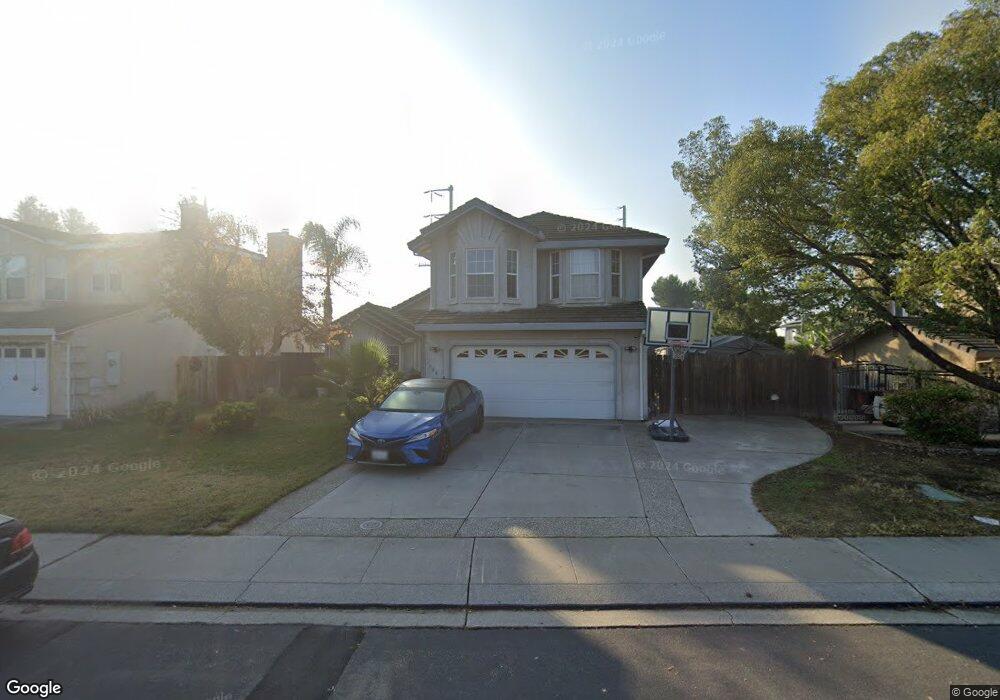
1224 Daniels St Manteca, CA 95337
Estimated Value: $450,000 - $674,000
4
Beds
3
Baths
2,327
Sq Ft
$261/Sq Ft
Est. Value
About This Home
This home is located at 1224 Daniels St, Manteca, CA 95337 and is currently estimated at $607,124, approximately $260 per square foot. 1224 Daniels St is a home located in San Joaquin County with nearby schools including Brock Elliott Elementary School and Sierra High School.
Ownership History
Date
Name
Owned For
Owner Type
Purchase Details
Closed on
Jun 6, 2001
Sold by
Digby Jeffrey L and Digby Kelly A
Bought by
Christian Willie A and Christian Tanya N
Current Estimated Value
Home Financials for this Owner
Home Financials are based on the most recent Mortgage that was taken out on this home.
Original Mortgage
$200,000
Interest Rate
6.63%
Purchase Details
Closed on
Jan 13, 1998
Sold by
Bank Of Stockton
Bought by
Digby Jeffrey L and Digby Kelly A
Home Financials for this Owner
Home Financials are based on the most recent Mortgage that was taken out on this home.
Original Mortgage
$156,000
Interest Rate
7.13%
Purchase Details
Closed on
Feb 26, 1997
Sold by
Gonsalves Junge Dev Ptp
Bought by
Bank Of Stockton
Create a Home Valuation Report for This Property
The Home Valuation Report is an in-depth analysis detailing your home's value as well as a comparison with similar homes in the area
Purchase History
| Date | Buyer | Sale Price | Title Company |
|---|---|---|---|
| Christian Willie A | $300,000 | Chicago Title Co | |
| Digby Jeffrey L | $195,000 | Central Valley Title Company | |
| Bank Of Stockton | $158,000 | -- |
Source: Public Records
Mortgage History
| Date | Status | Borrower | Loan Amount |
|---|---|---|---|
| Previous Owner | Christian Willie A | $200,000 | |
| Previous Owner | Digby Jeffrey L | $156,000 |
Source: Public Records
Tax History
| Year | Tax Paid | Tax Assessment Tax Assessment Total Assessment is a certain percentage of the fair market value that is determined by local assessors to be the total taxable value of land and additions on the property. | Land | Improvement |
|---|---|---|---|---|
| 2025 | $4,858 | $443,090 | $131,470 | $311,620 |
| 2024 | $4,720 | $434,403 | $128,893 | $305,510 |
| 2023 | $5,322 | $425,886 | $126,366 | $299,520 |
| 2022 | $5,251 | $417,537 | $123,889 | $293,648 |
| 2021 | $5,199 | $409,351 | $121,460 | $287,891 |
| 2020 | $5,014 | $405,155 | $120,215 | $284,940 |
| 2019 | $4,956 | $397,211 | $117,858 | $279,353 |
| 2018 | $4,898 | $389,424 | $115,548 | $273,876 |
| 2017 | $4,835 | $381,789 | $113,283 | $268,506 |
| 2016 | $4,733 | $374,304 | $111,062 | $263,242 |
| 2014 | $3,418 | $265,000 | $79,000 | $186,000 |
Source: Public Records
Map
Nearby Homes
- 896 Cinnamon Teal Ct
- 938 Snowgoose Ln
- 1015 Tenaya Ct
- 578 Schooner Place
- 1025 Barbados St
- 1176 Junction Dr
- 1432 Meridian St
- 1444 Meridian St
- 778 Mission Ridge Dr
- 1432 Driftwood Way
- 776 Folsom Way
- 865 Locust Ave
- 1164 Marion St
- 707 Chenin Blanc Dr
- 1142 Mammoth Dr
- 1821 Avo Way
- 1676 Red Ribbons Ln
- 1555 Sand Ln
- 1602 Oleander Ave
- 628 Mission Ridge Dr
- 1212 Daniels St
- 1238 Daniels St
- 1274 Junge Ct
- 1270 Hunt Rd
- 1276 Junge Ct
- 1223 Daniels St
- 1235 Daniels St
- 1211 Daniels St
- 1247 Daniels St
- 1273 Hunt Rd
- 1259 Daniels St
- 1172 S Union Rd
- 1278 Junge Ct
- 1196 S Union Rd
- 1280 Junge Ct
- 1271 Daniels St
- 1281 Hunt Rd
- 1230 Corwin Dr
- 1212 Corwin Dr
- 1285 Daniels St
Your Personal Tour Guide
Ask me questions while you tour the home.