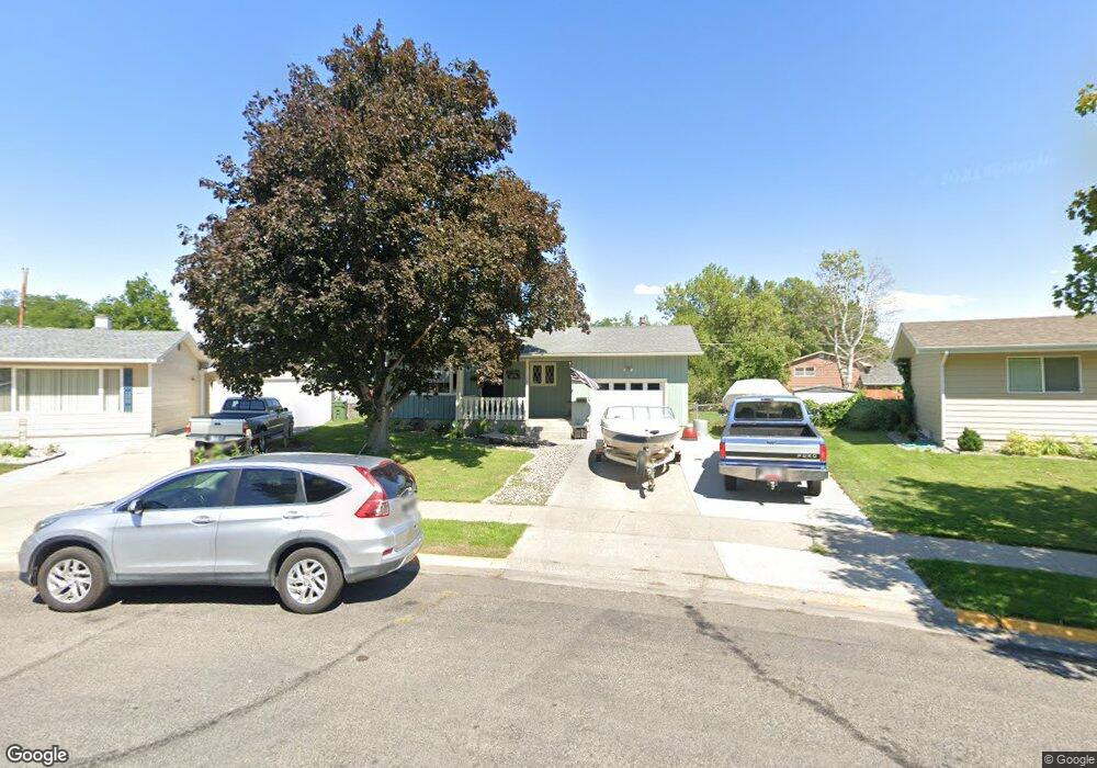
123 N Crestwood Dr Billings, MT 59102
West End NeighborhoodEstimated Value: $357,000 - $372,682
4
Beds
3
Baths
2,474
Sq Ft
$148/Sq Ft
Est. Value
About This Home
This home is located at 123 N Crestwood Dr, Billings, MT 59102 and is currently estimated at $365,921, approximately $147 per square foot. 123 N Crestwood Dr is a home located in Yellowstone County with nearby schools including Miles Avenue School, Will James Junior High School, and Billings West High School.
Ownership History
Date
Name
Owned For
Owner Type
Purchase Details
Closed on
Jan 14, 2022
Sold by
Johnson Sara Elise and Solberg Sara Elise
Bought by
Garbutt Paul J and Garbutt Elizabeth C
Current Estimated Value
Home Financials for this Owner
Home Financials are based on the most recent Mortgage that was taken out on this home.
Original Mortgage
$327,950
Outstanding Balance
$300,759
Interest Rate
3.05%
Mortgage Type
FHA
Estimated Equity
$65,162
Purchase Details
Closed on
May 30, 2012
Sold by
Schulz Travis and Schulze Christina
Bought by
Johnson Sarah Elise
Home Financials for this Owner
Home Financials are based on the most recent Mortgage that was taken out on this home.
Original Mortgage
$172,000
Interest Rate
3.86%
Mortgage Type
FHA
Create a Home Valuation Report for This Property
The Home Valuation Report is an in-depth analysis detailing your home's value as well as a comparison with similar homes in the area
Home Values in the Area
Average Home Value in this Area
Purchase History
| Date | Buyer | Sale Price | Title Company |
|---|---|---|---|
| Garbutt Paul J | -- | Chicago Title | |
| Johnson Sarah Elise | -- | St |
Source: Public Records
Mortgage History
| Date | Status | Borrower | Loan Amount |
|---|---|---|---|
| Open | Garbutt Paul J | $327,950 | |
| Previous Owner | Johnson Sarah Elise | $172,000 |
Source: Public Records
Tax History Compared to Growth
Tax History
| Year | Tax Paid | Tax Assessment Tax Assessment Total Assessment is a certain percentage of the fair market value that is determined by local assessors to be the total taxable value of land and additions on the property. | Land | Improvement |
|---|---|---|---|---|
| 2025 | $3,258 | $343,100 | $52,428 | $290,672 |
| 2024 | $3,258 | $321,300 | $48,832 | $272,468 |
| 2023 | $3,260 | $321,300 | $48,832 | $272,468 |
| 2022 | $2,757 | $236,300 | $0 | $0 |
| 2021 | $2,577 | $231,700 | $0 | $0 |
| 2020 | $2,758 | $238,200 | $0 | $0 |
| 2019 | $2,638 | $238,200 | $0 | $0 |
| 2018 | $2,486 | $218,500 | $0 | $0 |
| 2017 | $2,023 | $218,500 | $0 | $0 |
| 2016 | $2,225 | $201,600 | $0 | $0 |
| 2015 | $2,179 | $201,600 | $0 | $0 |
| 2014 | $1,948 | $94,605 | $0 | $0 |
Source: Public Records
Map
Nearby Homes
- 2207 Central Ave
- 2119 Hewitt Dr
- 2131 Hewitt Dr
- 126 Ardmore Dr
- 2305 Miles Ave
- 2150 Eldorado Dr
- 621 Nelson Dr
- 109 16th St W
- 2013 Clark Ave
- 2422 Miles Ave
- 2124 Lewis Ave
- 1705 Clark Ave
- 1720 Lewis Ave
- 0 Wyatt Cir Unit 356590
- 2300 Clark Ave
- 1119 21st St W
- 1704 Lewis Ave
- 1537 Wyoming Ave Unit D
- 1640 Lewis Ave
- 1540 Yellowstone Ave Unit D
- 117 N Crestwood Dr
- 209 N Crestwood Dr
- 204 19th St W
- 1912 Howard Ave
- 1912 Howard Ave Unit 1912 Howard Avenue -
- 118 19th St W
- 1933 Cook Ave
- 115 N Crestwood Dr
- 1938 Cook Ave
- 1920 Howard Ave
- 112 19th St W
- 1935 Cook Ave
- 113 N Crestwood Dr
- 0 Howard Ave Unit 4301339-6490402
- 1934 Howard Ave
- 106 19th St W
- 106 N Crestwood Dr
- 1945 Cook Ave
- 1940 Howard Ave
- 121 19th St W