
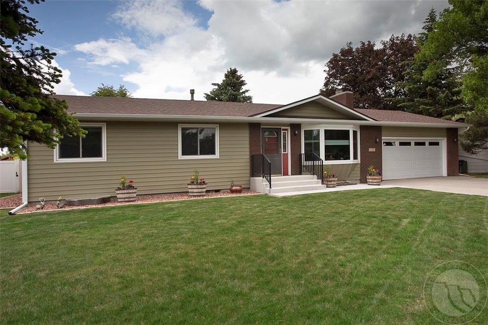
1230 Lonesome Pine Ln Billings, MT 59105
Billings Heights NeighborhoodEstimated payment $2,450/month
Total Views
2,183
4
Beds
2
Baths
2,576
Sq Ft
$152
Price per Sq Ft
Highlights
- Deck
- Covered patio or porch
- Cooling Available
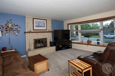
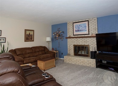
- 1 Fireplace
- 2 Car Attached Garage
- Shed
About This Home
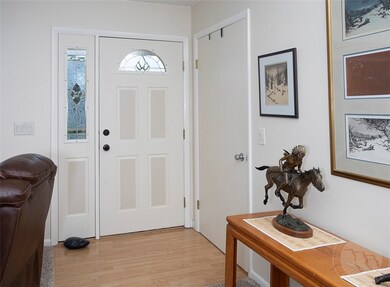
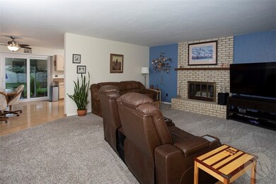
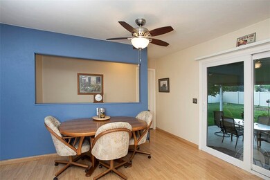
Beautifully updated 4-bedroom home with expansive yard in a desirable Billings Neighborhood. Move-in-ready gem! Step inside to discover a warm and welcoming interior filled with natural light. The two updated bathrooms boast fresh, contemporary finishes, including new vanities, custom tile work, and updated fixtures. The kitchen and living areas flow effortlessly together, ideal for entertaining or everyday living. Outside, you’ll find one of the standout features of this property—a fully fenced yard offering a shed and plenty of space for pets, play, gardening, or future projects. Imagine summer barbecues or simply relaxing in your own private outdoor oasis. Located just minutes from schools, shopping, parks, and medical services, this home offers the perfect balance of suburban tranquility and in-town convenience.
Listing Agent
Berkshire Hathaway HS Floberg Brokerage Phone: (406) 869-7618 License #RRE-BRO-LIC-98156 Listed on: 05/29/2025
Home Details
Home Type
- Single Family
Est. Annual Taxes
- $3,392
Year Built
- Built in 1976
Lot Details
- 10,800 Sq Ft Lot
- Sprinkler System
- Zoning described as Suburban Neighborhood Residential
Parking
- 2 Car Attached Garage
- Garage Door Opener
Home Design
- Asphalt Roof
- Metal Siding
Interior Spaces
- 2,576 Sq Ft Home
- 2-Story Property
- 1 Fireplace
- Basement Fills Entire Space Under The House
- Storm Doors
Kitchen
- Oven
- Range
- Dishwasher
- Disposal
Bedrooms and Bathrooms
- 4 Bedrooms | 3 Main Level Bedrooms
- 2 Full Bathrooms
Outdoor Features
- Deck
- Covered patio or porch
- Shed
Schools
- Sandstone Elementary School
- Castle Rock Middle School
- Skyview High School
Utilities
- Cooling Available
- Forced Air Heating System
Listing and Financial Details
- Assessor Parcel Number A21059
Community Details
Overview
- Golden View Subd Subdivision
Building Details
Map
Create a Home Valuation Report for This Property
The Home Valuation Report is an in-depth analysis detailing your home's value as well as a comparison with similar homes in the area
Home Values in the Area
Average Home Value in this Area
Tax History
| Year | Tax Paid | Tax Assessment Tax Assessment Total Assessment is a certain percentage of the fair market value that is determined by local assessors to be the total taxable value of land and additions on the property. | Land | Improvement |
|---|---|---|---|---|
| 2024 | $3,392 | $332,800 | $65,301 | $267,499 |
| 2023 | $3,400 | $332,800 | $65,301 | $267,499 |
| 2022 | $2,142 | $226,800 | $0 | $0 |
| 2021 | $2,560 | $226,800 | $0 | $0 |
| 2020 | $2,529 | $213,800 | $0 | $0 |
| 2019 | $2,420 | $213,800 | $0 | $0 |
| 2018 | $2,471 | $215,600 | $0 | $0 |
| 2017 | $1,996 | $215,600 | $0 | $0 |
| 2016 | $2,060 | $182,700 | $0 | $0 |
| 2015 | $2,017 | $182,700 | $0 | $0 |
| 2014 | $1,998 | $96,937 | $0 | $0 |
Source: Public Records
Property History
| Date | Event | Price | Change | Sq Ft Price |
|---|---|---|---|---|
| 05/29/2025 05/29/25 | For Sale | $392,500 | -- | $152 / Sq Ft |
Source: Billings Multiple Listing Service
Purchase History
| Date | Type | Sale Price | Title Company |
|---|---|---|---|
| Interfamily Deed Transfer | -- | None Available |
Source: Public Records
Mortgage History
| Date | Status | Loan Amount | Loan Type |
|---|---|---|---|
| Closed | $150,000 | Stand Alone Refi Refinance Of Original Loan | |
| Closed | $36,900 | New Conventional | |
| Closed | $63,500 | New Conventional |
Source: Public Records
Similar Homes in Billings, MT
Source: Billings Multiple Listing Service
MLS Number: 353109
APN: 03-1033-21-1-02-03-0000
Disclaimer: Certain information contained herein is derived from information provided by parties other than Homes.com. All information provided is deemed reliable, but is not guaranteed to be accurate and should be independently verified.
![]() IDX information is provided exclusively for personal, non-commercial use, and may not be used for any purpose other than to identify prospective properties consumers may be interested in purchasing. Information is deemed reliable but not guaranteed.
IDX information is provided exclusively for personal, non-commercial use, and may not be used for any purpose other than to identify prospective properties consumers may be interested in purchasing. Information is deemed reliable but not guaranteed.
Nearby Homes
- 1014 Aronson Ave
- 1250 Hardrock Ln
- 1034 Nutter Blvd
- 1328 Nutter Blvd
- 69 Nugget Place
- 1152 Toole Ct
- 1513 Westchester Square E
- 510 Declaration Ave
- 329 Stewart Ct N
- 243 Westchester Square N Unit A2
- 189 Norris Ct E
- 347 Westchester Square N
- 1017 Toole Cir
- 365 Stewart Ct S
- 931 Shamrock Ln
- TBD Saint Andrews Dr
- 880 Garnet Ave
- 153 W Hilltop Rd
- 2027 Gleneagles Blvd
- 2011 Gleneagles Blvd
- 191 Bohl Ave
- 1551 Nottingham Place
- 850 Lake Elmo Dr
- 324 Moccasin Trail Unit 330
- 601 Samuel Ct
- 821 Bench Blvd
- 810 Crist Dr
- 2141 Burnstead Dr
- 1105 N 22nd St
- 1148 N 25th St
- 124 N 24th St
- 2310 1st Ave N
- 124 N 29th St
- 124 N 29th St
- 429 N 33rd St
- 420 Lordwith Dr
- 644 Avenue F
- 1145 Ponderosa Dr
- 715 Alderson Ave
- 310 3rd St W Unit 201