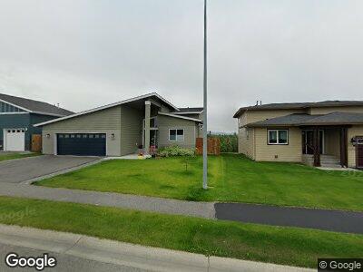
1238 Northpointe Bluff Dr Anchorage, AK 99501
Government Hill NeighborhoodEstimated Value: $598,000 - $674,424
3
Beds
3
Baths
1,356
Sq Ft
$469/Sq Ft
Est. Value
About This Home
This home is located at 1238 Northpointe Bluff Dr, Anchorage, AK 99501 and is currently estimated at $636,212, approximately $469 per square foot. 1238 Northpointe Bluff Dr is a home with nearby schools including Government Hill Elementary School, Central Middle School of Science, and West High School.
Ownership History
Date
Name
Owned For
Owner Type
Purchase Details
Closed on
Jun 10, 2015
Sold by
Spinell Homes Inc
Bought by
Sis Christopher S and Sis Laura Y
Current Estimated Value
Home Financials for this Owner
Home Financials are based on the most recent Mortgage that was taken out on this home.
Original Mortgage
$265,235
Outstanding Balance
$211,008
Interest Rate
3.64%
Mortgage Type
New Conventional
Create a Home Valuation Report for This Property
The Home Valuation Report is an in-depth analysis detailing your home's value as well as a comparison with similar homes in the area
Home Values in the Area
Average Home Value in this Area
Purchase History
| Date | Buyer | Sale Price | Title Company |
|---|---|---|---|
| Sis Christopher S | -- | Fidelity Title Agency Ak Llc |
Source: Public Records
Mortgage History
| Date | Status | Borrower | Loan Amount |
|---|---|---|---|
| Open | Sis Christopher S | $265,235 |
Source: Public Records
Tax History Compared to Growth
Tax History
| Year | Tax Paid | Tax Assessment Tax Assessment Total Assessment is a certain percentage of the fair market value that is determined by local assessors to be the total taxable value of land and additions on the property. | Land | Improvement |
|---|---|---|---|---|
| 2024 | $8,875 | $624,700 | $148,800 | $475,900 |
| 2023 | $9,830 | $577,200 | $141,800 | $435,400 |
| 2022 | $8,890 | $577,900 | $141,800 | $436,100 |
| 2021 | $9,606 | $533,100 | $141,800 | $391,300 |
| 2020 | $8,138 | $529,000 | $141,800 | $387,200 |
| 2019 | $7,809 | $527,300 | $141,800 | $385,500 |
| 2018 | $7,765 | $523,500 | $141,800 | $381,700 |
| 2017 | $7,683 | $510,600 | $141,800 | $368,800 |
| 2016 | -- | $499,700 | $151,200 | $348,500 |
| 2015 | -- | $151,200 | $151,200 | $0 |
| 2014 | -- | $0 | $0 | $0 |
Source: Public Records
Map
Nearby Homes
- 1382 Northbluff Dr Unit 4B
- 1091 Northpointe Bluff Dr
- 725 Station Ln Unit A6
- 000 E 3rd Ave
- L1 BL N Addn 4
- 124 E Cook Ave
- 116 W Manor Ave
- 108 E Cook Ave
- 619 E 5th Ave
- 618 Gambell St
- 890 Orca St
- 915 Hyder St
- 1401 Hyder St
- 934 Medfra St
- 1401 E 10th Ave
- 221 E 7th Ave Unit 308
- 221 E 7th Ave Unit 311
- 222 E 7th Ave Unit 106
- 3111 Commercial Dr
- 818 E 10th Ave
- 1238 Northpointe Bluff Dr
- 1226 Northpointe Bluff Dr
- 1250 Northpointe Bluff Dr
- 1214 Northpointe Bluff Dr
- 1262 Northpointe Bluff Dr
- 1202 Northpointe Bluff Dr
- 1274 Northpointe Bluff Dr
- 1215 Northpointe Bluff Dr
- L14 B2 Northpointe Bluff Dr
- 1296 Northpointe Bluff Dr
- 1190 Northpointe Bluff Dr
- 1288 Northpointe Bluff Dr
- 1193 Northpointe Bluff Dr
- 1181 Northpointe Bluff Dr
- 1174 Northpointe Bluff Dr
- L19 B1 Northpointe Bluff
- L20 B1 N Pointe Bluff Dr
- L27 B1 N Pointe Bluff Dr
- L9 B3 Northpointe Bluff
- L23 B1 Northpointe Bluff Dr