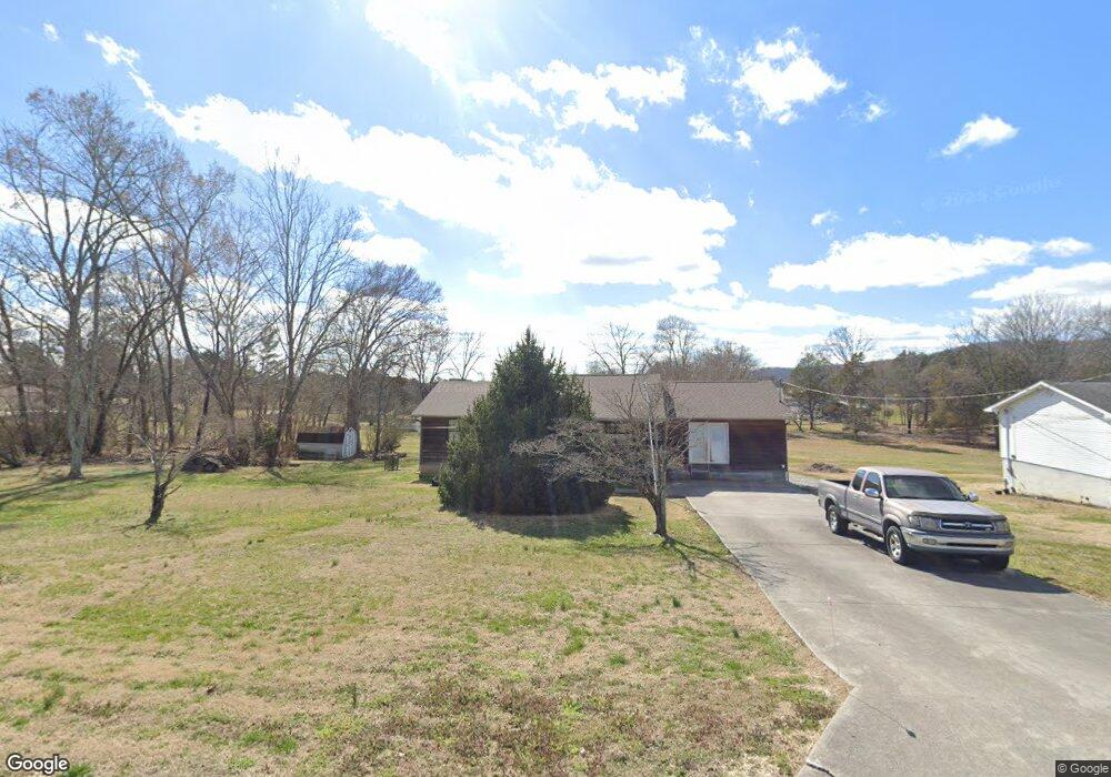
124 Mynatt Cir Corryton, TN 37721
Plainview NeighborhoodEstimated Value: $223,655 - $336,000
--
Bed
1
Bath
1,440
Sq Ft
$210/Sq Ft
Est. Value
About This Home
This home is located at 124 Mynatt Cir, Corryton, TN 37721 and is currently estimated at $301,914, approximately $209 per square foot. 124 Mynatt Cir is a home located in Union County with nearby schools including Luttrell Elementary School, Union County High School, and H Maynard Middle School.
Ownership History
Date
Name
Owned For
Owner Type
Purchase Details
Closed on
Jul 18, 2019
Sold by
West Kimberly G
Bought by
West Bradley K
Current Estimated Value
Purchase Details
Closed on
Jun 23, 1988
Bought by
West Bradley
Purchase Details
Closed on
Jun 7, 1988
Purchase Details
Closed on
Oct 3, 1978
Bought by
Guy Warner
Create a Home Valuation Report for This Property
The Home Valuation Report is an in-depth analysis detailing your home's value as well as a comparison with similar homes in the area
Home Values in the Area
Average Home Value in this Area
Purchase History
| Date | Buyer | Sale Price | Title Company |
|---|---|---|---|
| West Bradley K | -- | None Available | |
| West Bradley K | -- | None Available | |
| West Bradley | -- | -- | |
| West Bradley | -- | -- | |
| -- | $4,200 | -- | |
| -- | $4,200 | -- | |
| Guy Warner | -- | -- | |
| Guy Warner | -- | -- |
Source: Public Records
Tax History Compared to Growth
Tax History
| Year | Tax Paid | Tax Assessment Tax Assessment Total Assessment is a certain percentage of the fair market value that is determined by local assessors to be the total taxable value of land and additions on the property. | Land | Improvement |
|---|---|---|---|---|
| 2025 | $773 | $40,675 | $0 | $0 |
| 2024 | $773 | $40,675 | $4,500 | $36,175 |
| 2023 | $773 | $40,675 | $4,500 | $36,175 |
| 2022 | $647 | $40,675 | $4,500 | $36,175 |
| 2021 | $592 | $27,675 | $4,000 | $23,675 |
| 2020 | $592 | $27,675 | $4,000 | $23,675 |
| 2019 | $592 | $27,675 | $4,000 | $23,675 |
| 2018 | $592 | $27,675 | $4,000 | $23,675 |
| 2017 | $592 | $27,675 | $4,000 | $23,675 |
| 2016 | $537 | $24,750 | $3,500 | $21,250 |
| 2015 | $537 | $24,750 | $3,500 | $21,250 |
| 2014 | $443 | $24,744 | $0 | $0 |
Source: Public Records
Map
Nearby Homes
- 1907 Tazewell Pike
- 163 Meadowbreeze Rd
- 130 Gentry Ln
- 157 Acorn Dr
- 8408 Graceland Rd
- 8416 Graceland Rd
- 265 Pecan Cir
- 140 Ruth St
- 711 Stowers Dr
- 106 Stowers Dr
- 343 Angus Crossing Unit 12
- 382 2nd St
- 540 Monday Rd
- 7945 Rodgers Rd
- 8012 Corryton Rd
- 295 Clear Branch Rd
- Lot 7 Rodgers Rd
- 8.30 acres Wolfenbarger Ln
- 00 Old Tazewell Pike
- 232 Sallings Rd
- 120 Mynatt Cir
- 116 Mynatt Cir
- 119 Mynatt Cir
- 109 Ashley Ln
- 115 Mynatt Cir
- 105 Ashley Ln
- 170 Mynatt Cir
- 160 Peach Tree Ln
- 117 Ashley Ln
- 2005 Tazewell Pike
- 143 Peach Tree Ln
- 186 Mynatt Cir
- 198 Mynatt Cir
- 214 Mynatt Cir
- 1901 Tazewell Pike
- 182 Mynatt Cir
- 116 Ashley Ln Unit 122
- 2104 Tazewell Pike
- 1845 Tazewell Pike
- 2112 Tazewell Pike