Estimated Value: $947,000 - $1,041,000
4
Beds
2
Baths
1,672
Sq Ft
$590/Sq Ft
Est. Value
About This Home
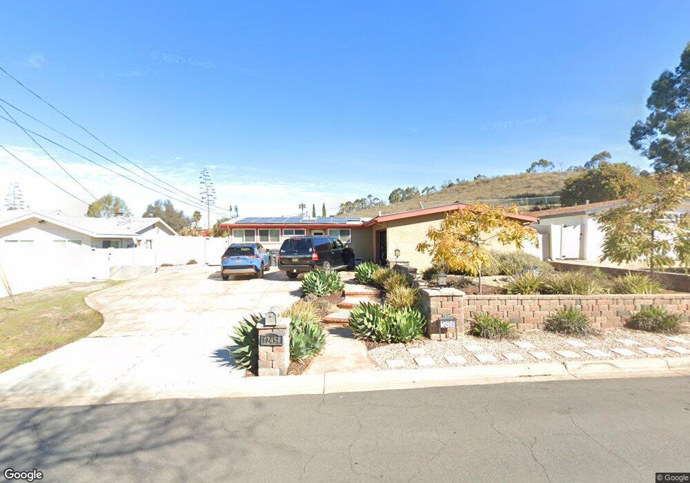
This home is located at 12454 Vaughan Rd, Poway, CA 92064 and is currently estimated at $985,704, approximately $589 per square foot. 12454 Vaughan Rd is a home located in San Diego County with nearby schools including Pomerado Elementary, Meadowbrook Middle, and Poway High.
Ownership History
Date
Name
Owned For
Owner Type
Purchase Details
Closed on
Apr 12, 2012
Sold by
Mcquen Michael W and Mcquen Lisa A
Bought by
Mcquen Michael W and Mcquen Lisa A
Current Estimated Value
Purchase Details
Closed on
Apr 21, 1994
Sold by
Cook Kevin D and Cook Paula R
Bought by
Mcquen Michael W and Mcquen Lisa A
Home Financials for this Owner
Home Financials are based on the most recent Mortgage that was taken out on this home.
Original Mortgage
$153,630
Interest Rate
8.53%
Mortgage Type
FHA
Purchase Details
Closed on
Oct 12, 1988
Create a Home Valuation Report for This Property
The Home Valuation Report is an in-depth analysis detailing your home's value as well as a comparison with similar homes in the area
Home Values in the Area
Average Home Value in this Area
Purchase History
| Date | Buyer | Sale Price | Title Company |
|---|---|---|---|
| Mcquen Michael W | -- | None Available | |
| Mcquen Michael W | $157,000 | South Coast Title Company | |
| -- | $115,000 | -- |
Source: Public Records
Mortgage History
| Date | Status | Borrower | Loan Amount |
|---|---|---|---|
| Previous Owner | Mcquen Michael W | $153,630 |
Source: Public Records
Tax History Compared to Growth
Tax History
| Year | Tax Paid | Tax Assessment Tax Assessment Total Assessment is a certain percentage of the fair market value that is determined by local assessors to be the total taxable value of land and additions on the property. | Land | Improvement |
|---|---|---|---|---|
| 2025 | $3,470 | $313,708 | $140,430 | $173,278 |
| 2024 | $3,470 | $307,558 | $137,677 | $169,881 |
| 2023 | $3,395 | $301,528 | $134,978 | $166,550 |
| 2022 | $3,338 | $295,617 | $132,332 | $163,285 |
| 2021 | $3,295 | $289,822 | $129,738 | $160,084 |
| 2020 | $3,250 | $286,851 | $128,408 | $158,443 |
| 2019 | $3,167 | $281,228 | $125,891 | $155,337 |
| 2018 | $3,078 | $275,715 | $123,423 | $152,292 |
| 2017 | $170 | $270,309 | $121,003 | $149,306 |
| 2016 | $2,933 | $265,010 | $118,631 | $146,379 |
| 2015 | $2,890 | $261,031 | $116,850 | $144,181 |
| 2014 | $2,823 | $255,919 | $114,562 | $141,357 |
Source: Public Records
Map
Nearby Homes
- 13834 Tobiasson Rd
- 13824 Powers Rd
- 13751 Powers Rd
- 12311 Witt Rd
- 14001 Saddlewood Dr
- 12216 Holland Rd
- 13522 Utopia Rd
- 13737 Esprit Ave
- 13520 Carriage Rd
- 13416 Tobiasson Rd
- 12224 Mulholland Ct
- 13417 Silver Lake Dr
- 12194 Wilsey Way
- 12616 Robison Blvd
- 13599 Tradition St
- 12939 Cree Ct
- 13958 Carriage Rd
- 12450 Robison Blvd
- 12643 Robison Blvd Unit 217
- 12643 Robison Blvd Unit 121
- 12448 Vaughan Rd
- 12442 Vaughan Rd
- 13853 Tobiasson Rd
- 13852 Tobiasson Rd
- 13847 Tobiasson Rd
- 13905 Frame Rd
- 13911 Frame Rd
- 13846 Tobiasson Rd
- 12466 Vaughan Rd
- 13917 Frame Rd
- 13851 Frame Rd
- 13841 Tobiasson Rd
- 13923 Frame Rd
- 12461 Vaughan Rd
- 13840 Tobiasson Rd
- 13845 Frame Rd
- 13929 Frame Rd
- 13835 Tobiasson Rd
- 13839 Frame Rd
- 13935 Frame Rd