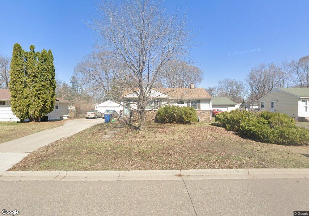
1249 Ryan Ave E Saint Paul, MN 55109
Sherwood Glen NeighborhoodEstimated Value: $319,951 - $348,000
3
Beds
1
Bath
868
Sq Ft
$379/Sq Ft
Est. Value
About This Home
This home is located at 1249 Ryan Ave E, Saint Paul, MN 55109 and is currently estimated at $329,238, approximately $379 per square foot. 1249 Ryan Ave E is a home located in Ramsey County with nearby schools including Weaver Elementary School, John Glenn Middle School, and Mounds Park Academy.
Ownership History
Date
Name
Owned For
Owner Type
Purchase Details
Closed on
Oct 27, 2016
Sold by
Miner Kristi Terese and Miner David
Bought by
Grundhofer Jamie and Klapak Dustin
Current Estimated Value
Home Financials for this Owner
Home Financials are based on the most recent Mortgage that was taken out on this home.
Original Mortgage
$175,750
Outstanding Balance
$141,319
Interest Rate
3.47%
Mortgage Type
New Conventional
Estimated Equity
$187,919
Create a Home Valuation Report for This Property
The Home Valuation Report is an in-depth analysis detailing your home's value as well as a comparison with similar homes in the area
Home Values in the Area
Average Home Value in this Area
Purchase History
| Date | Buyer | Sale Price | Title Company |
|---|---|---|---|
| Grundhofer Jamie | $188,236 | Executive Title |
Source: Public Records
Mortgage History
| Date | Status | Borrower | Loan Amount |
|---|---|---|---|
| Open | Grundhofer Jamie | $175,750 |
Source: Public Records
Tax History
| Year | Tax Paid | Tax Assessment Tax Assessment Total Assessment is a certain percentage of the fair market value that is determined by local assessors to be the total taxable value of land and additions on the property. | Land | Improvement |
|---|---|---|---|---|
| 2025 | $3,890 | $313,000 | $62,400 | $250,600 |
| 2023 | $3,890 | $283,000 | $62,400 | $220,600 |
| 2022 | $3,414 | $276,600 | $62,400 | $214,200 |
| 2021 | $3,108 | $240,800 | $62,400 | $178,400 |
| 2020 | $2,960 | $226,000 | $62,400 | $163,600 |
| 2019 | $2,550 | $203,800 | $62,400 | $141,400 |
| 2018 | $2,480 | $182,000 | $62,400 | $119,600 |
| 2017 | $2,792 | $173,500 | $62,400 | $111,100 |
| 2016 | $2,862 | $0 | $0 | $0 |
| 2015 | $2,622 | $169,600 | $57,200 | $112,400 |
| 2014 | $2,012 | $0 | $0 | $0 |
Source: Public Records
Map
Nearby Homes
- 2022 English St
- 1290 Belmont Ln E
- 1800 Edward St
- 1855 Birmingham St
- 1083 Gordon Ave
- 1764 English St
- 1745 Duluth St
- 1740 English St
- 1875 E Shore Dr Unit 302
- 1669 Clarence St
- 1984 Prosperity Rd
- 1894 Maryknoll Ave N
- 1664 Barclay St
- 1563 Clarence St
- 1544 Duluth St
- 1561 Clarence St
- 1571 Christie Place
- 1581 Christie Place
- 1460 Hoyt Ave E
- 1579 Grandview Ave E
- 1255 Ryan Ave E
- 1241 Ryan Ave E
- 1233 Ryan Ave E
- 1226 Shryer Ave E
- 2001 Chambers St
- 1232 Shryer Ave E
- 2007 Chambers St
- 1222 Shryer Ave E
- 1244 Ryan Ave E
- 1250 Ryan Ave E
- 1227 Ryan Ave E
- 2013 Chambers St
- 1236 Ryan Ave E
- 1258 Ryan Ave E
- 1230 Ryan Ave E
- 1216 Shryer Ave E
- 1264 Ryan Ave E
- 1219 Ryan Ave E
- 2021 Chambers St
- 1246 Shryer Ave E
Your Personal Tour Guide
Ask me questions while you tour the home.