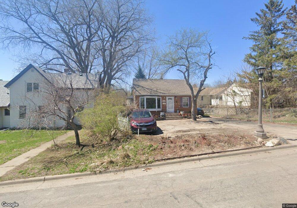
1251 Kent St Saint Paul, MN 55117
North End NeighborhoodEstimated Value: $314,128 - $356,000
4
Beds
1
Bath
874
Sq Ft
$377/Sq Ft
Est. Value
About This Home
This home is located at 1251 Kent St, Saint Paul, MN 55117 and is currently estimated at $329,282, approximately $376 per square foot. 1251 Kent St is a home located in Ramsey County with nearby schools including Como Park Elementary School, Murray Middle School, and Como Park Senior High School.
Ownership History
Date
Name
Owned For
Owner Type
Purchase Details
Closed on
Nov 30, 2017
Sold by
Johnson Brian C and Johnson Mindy R
Bought by
Aye Po and Gay Bult
Current Estimated Value
Home Financials for this Owner
Home Financials are based on the most recent Mortgage that was taken out on this home.
Original Mortgage
$205,200
Outstanding Balance
$172,760
Interest Rate
3.94%
Mortgage Type
New Conventional
Estimated Equity
$156,522
Purchase Details
Closed on
Mar 4, 2015
Sold by
Dafnopulos Dimitrios Dimitrios
Bought by
Johnson Brian Brian
Home Financials for this Owner
Home Financials are based on the most recent Mortgage that was taken out on this home.
Original Mortgage
$171,900
Interest Rate
3.8%
Create a Home Valuation Report for This Property
The Home Valuation Report is an in-depth analysis detailing your home's value as well as a comparison with similar homes in the area
Home Values in the Area
Average Home Value in this Area
Purchase History
| Date | Buyer | Sale Price | Title Company |
|---|---|---|---|
| Aye Po | $216,000 | None Available | |
| Johnson Brian Brian | $171,900 | -- |
Source: Public Records
Mortgage History
| Date | Status | Borrower | Loan Amount |
|---|---|---|---|
| Open | Aye Po | $205,200 | |
| Previous Owner | Johnson Brian Brian | $171,900 |
Source: Public Records
Tax History Compared to Growth
Tax History
| Year | Tax Paid | Tax Assessment Tax Assessment Total Assessment is a certain percentage of the fair market value that is determined by local assessors to be the total taxable value of land and additions on the property. | Land | Improvement |
|---|---|---|---|---|
| 2025 | $5,006 | $344,800 | $50,000 | $294,800 |
| 2023 | $5,006 | $328,300 | $50,000 | $278,300 |
| 2022 | $4,300 | $327,300 | $50,000 | $277,300 |
| 2021 | $3,730 | $265,800 | $50,000 | $215,800 |
| 2020 | $3,596 | $249,800 | $32,400 | $217,400 |
| 2019 | $3,468 | $226,700 | $32,400 | $194,300 |
| 2018 | $3,460 | $216,900 | $32,400 | $184,500 |
| 2017 | $2,882 | $215,900 | $32,400 | $183,500 |
| 2016 | $2,864 | $0 | $0 | $0 |
| 2015 | $2,820 | $184,300 | $32,400 | $151,900 |
| 2014 | $2,890 | $0 | $0 | $0 |
Source: Public Records
Map
Nearby Homes
- tbd MacKubin St
- 1342 Dale St N
- 1241 Maywood St
- 1165 Norton St
- 1176 Norton St
- 1175 Arundel St
- 1104 MacKubin St
- 1464 Maywood St
- 766 Maryland Ave W
- 397 Cottage Ave W Unit 3
- 1063 Dale St N
- 1049 Kent St
- 1457 Arundel St
- 408 Arlington Ave W
- 1083 Western Ave N
- 705 Como Ave
- 1005 Como Blvd E
- 569 Hatch Ave
- 1110 Virginia St
- 1539 Dale St N
- 570 Orange Ave W
- 1247 Kent St
- 1239 Kent St
- 1239 1239 Kent-Street-
- 1252 Danforth St
- 1256 Danforth St
- 1244 Danforth St
- 1260 Danforth St
- 558 Orange Ave W
- 569 Orange Ave W
- 1240 Kent St
- 1231 Kent St
- 1236 1236 Danforth-Street-
- 1236 Danforth St
- 550 Orange Ave W
- 1271 Kent St
- 1264 Danforth St
- 555 Hawthorne Ave W
- 1232 Danforth St
- 1225 Kent St