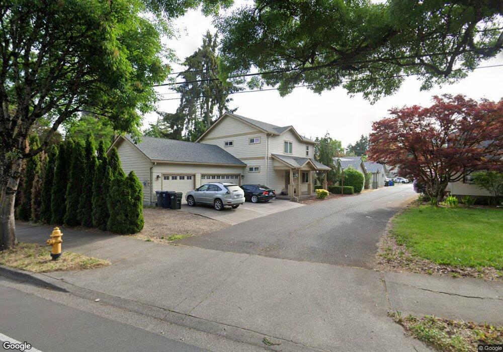
1259 River Rd Eugene, OR 97404
River Road NeighborhoodEstimated Value: $390,000 - $524,000
3
Beds
2
Baths
1,700
Sq Ft
$276/Sq Ft
Est. Value
About This Home
This home is located at 1259 River Rd, Eugene, OR 97404 and is currently estimated at $468,720, approximately $275 per square foot. 1259 River Rd is a home located in Lane County with nearby schools including River Road/El Camino del Río Elementary School, Kelly Middle School, and North Eugene High School.
Ownership History
Date
Name
Owned For
Owner Type
Purchase Details
Closed on
May 25, 2022
Sold by
Harley D Llc
Bought by
Phillips Living Trust
Current Estimated Value
Purchase Details
Closed on
Sep 19, 2011
Sold by
Phillips Steven C and Phillips Nancy K
Bought by
Dwg2 Llc
Home Financials for this Owner
Home Financials are based on the most recent Mortgage that was taken out on this home.
Original Mortgage
$176,000
Interest Rate
4.53%
Mortgage Type
New Conventional
Purchase Details
Closed on
Aug 5, 2011
Sold by
Dwg2 Llc
Bought by
Phillips Steven C and Phillips Nancy K
Home Financials for this Owner
Home Financials are based on the most recent Mortgage that was taken out on this home.
Original Mortgage
$176,000
Interest Rate
4.53%
Mortgage Type
New Conventional
Purchase Details
Closed on
Dec 28, 2009
Sold by
Pensco Trust Company
Bought by
Phillips Steven C
Purchase Details
Closed on
Dec 23, 2009
Sold by
Phillips Steven C
Bought by
Dwg2 Llc
Create a Home Valuation Report for This Property
The Home Valuation Report is an in-depth analysis detailing your home's value as well as a comparison with similar homes in the area
Home Values in the Area
Average Home Value in this Area
Purchase History
| Date | Buyer | Sale Price | Title Company |
|---|---|---|---|
| Phillips Living Trust | -- | None Listed On Document | |
| Dwg2 Llc | -- | Cascade Title Company | |
| Phillips Steven C | -- | Cascade Title Company | |
| Phillips Steven C | -- | Accommodation | |
| Dwg2 Llc | -- | Accommodation |
Source: Public Records
Mortgage History
| Date | Status | Borrower | Loan Amount |
|---|---|---|---|
| Previous Owner | Phillips Steven C | $176,000 |
Source: Public Records
Tax History
| Year | Tax Paid | Tax Assessment Tax Assessment Total Assessment is a certain percentage of the fair market value that is determined by local assessors to be the total taxable value of land and additions on the property. | Land | Improvement |
|---|---|---|---|---|
| 2025 | $3,988 | $204,681 | -- | -- |
| 2024 | $3,938 | $198,720 | -- | -- |
| 2023 | $3,938 | $192,933 | $0 | $0 |
| 2022 | $3,690 | $187,314 | $0 | $0 |
| 2021 | $3,465 | $181,859 | $0 | $0 |
| 2020 | $3,478 | $176,563 | $0 | $0 |
| 2019 | $3,359 | $171,421 | $0 | $0 |
| 2018 | $3,162 | $161,582 | $0 | $0 |
| 2017 | $3,020 | $161,582 | $0 | $0 |
| 2016 | $2,945 | $156,876 | $0 | $0 |
| 2015 | $2,861 | $152,307 | $0 | $0 |
| 2014 | $2,803 | $147,871 | $0 | $0 |
Source: Public Records
Map
Nearby Homes
- 260 Greenleaf Ave
- 1420 Evergreen Dr
- 172 Norman Ave
- 32 Marion Ln
- 1360 Andersen Ln
- 1295 Betty Ln
- 172 Oakleigh Ln Unit 221
- 574 Wimbledon Ct
- 1666 Evergreen Dr
- 1010 Horn Ln
- 1685 Evergreen Dr
- 606 Wimbledon Ct
- 882 Jackies Ln
- 805 River Rd
- 1314 Dalton Dr
- 2709 Riverwalk Loop
- 1927 Lake Isle Dr
- 2874 Riverwalk Loop
- 1555 Escalante St
- 820 Park Terrace
Your Personal Tour Guide
Ask me questions while you tour the home.