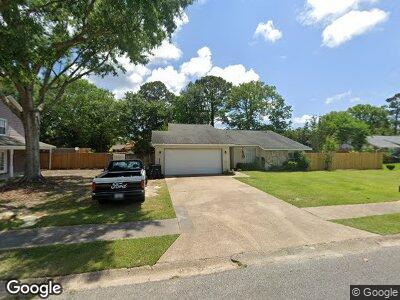
126 Reynolds Cir Ocean Springs, MS 39564
Estimated Value: $204,002 - $271,000
--
Bed
2
Baths
1,461
Sq Ft
$165/Sq Ft
Est. Value
About This Home
This home is located at 126 Reynolds Cir, Ocean Springs, MS 39564 and is currently estimated at $241,751, approximately $165 per square foot. 126 Reynolds Cir is a home located in Jackson County with nearby schools including Pecan Park Elementary School, Ocean Springs Middle School, and Ocean Springs High School.
Ownership History
Date
Name
Owned For
Owner Type
Purchase Details
Closed on
Oct 20, 2018
Sold by
Lanzer Beverly E and Lanzer Donald
Bought by
Lanzer Donald and Lanzer Beverly E
Current Estimated Value
Home Financials for this Owner
Home Financials are based on the most recent Mortgage that was taken out on this home.
Original Mortgage
$50,875
Outstanding Balance
$31,843
Interest Rate
4.25%
Mortgage Type
FHA
Estimated Equity
$189,832
Create a Home Valuation Report for This Property
The Home Valuation Report is an in-depth analysis detailing your home's value as well as a comparison with similar homes in the area
Home Values in the Area
Average Home Value in this Area
Purchase History
| Date | Buyer | Sale Price | Title Company |
|---|---|---|---|
| Lanzer Donald | -- | -- |
Source: Public Records
Mortgage History
| Date | Status | Borrower | Loan Amount |
|---|---|---|---|
| Open | Lanzer Donald | $50,875 | |
| Previous Owner | Lanzer Beverly E | $24,420 |
Source: Public Records
Tax History Compared to Growth
Tax History
| Year | Tax Paid | Tax Assessment Tax Assessment Total Assessment is a certain percentage of the fair market value that is determined by local assessors to be the total taxable value of land and additions on the property. | Land | Improvement |
|---|---|---|---|---|
| 2024 | $564 | $12,414 | $2,311 | $10,103 |
| 2023 | $564 | $12,414 | $2,311 | $10,103 |
| 2022 | $572 | $11,415 | $0 | $0 |
| 2021 | $564 | $11,415 | $11,415 | $0 |
| 2020 | $569 | $11,415 | $2,164 | $9,251 |
| 2019 | $567 | $11,415 | $2,164 | $9,251 |
| 2018 | $1,307 | $11,147 | $2,164 | $8,983 |
| 2017 | $1,307 | $11,147 | $2,164 | $8,983 |
| 2016 | $1,274 | $11,147 | $2,164 | $8,983 |
| 2015 | $1,157 | $101,300 | $21,640 | $79,660 |
| 2014 | $1,118 | $9,929 | $2,164 | $7,765 |
| 2013 | $1,086 | $9,929 | $2,164 | $7,765 |
Source: Public Records
Map
Nearby Homes
- 133 Reynolds Cir
- 110 Reynolds Cir
- 139 Booth Cir
- 3709 Point Clear Dr
- 3600 Dijon Ave
- 3607 Dijon Ave
- 3611 Hedgewood Cove
- 3603 Fernwood Dr
- 807 Woodglen Dr
- 803 Woodglen Dr
- 909 Magnolia Bayou Blvd
- 1203 Magnolia Bayou Blvd
- 0000 Pabst Rd
- 3612 Perryman Rd
- 0 Perryman Rd
- 3823 Versailles Ct
- 3629 Perryman Rd
- 3612 Miles Ln
- 3605 Knapp Rd
- 219 Sandy Dr
- 126 Reynolds Cir
- 124 Reynolds Cir
- 117 Reynolds Cir
- 0 Reynolds Cir
- 115 Mark Daniels Cir
- 113 Mark Daniels Cir
- 127 Reynolds Cir
- 117 Mark Daniels Cir
- 122 Reynolds Cir
- 132 Reynolds Cir
- 111 Mark Daniels Cir
- 125 Reynolds Cir
- 123 Reynolds Cir
- 129 Reynolds Cir
- 119 Mark Daniels Cir
- 121 Reynolds Cir
- 116 Reynolds Cir
- 114 Mark Daniels Cir
- 112 Mark Daniels Cir
- 116 Mark Daniels Cir