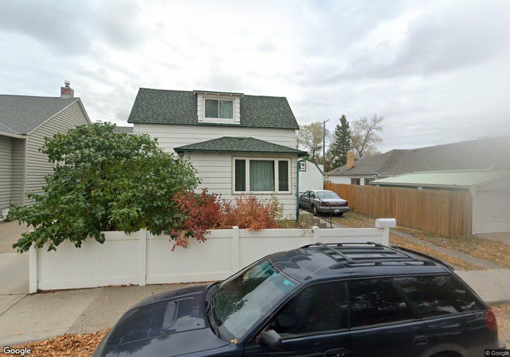
127 20th St Black Eagle, MT 59414
Estimated Value: $168,000 - $225,196
2
Beds
1
Bath
1,011
Sq Ft
$197/Sq Ft
Est. Value
About This Home
This home is located at 127 20th St, Black Eagle, MT 59414 and is currently estimated at $199,549, approximately $197 per square foot. 127 20th St is a home located in Cascade County with nearby schools including Sacajawea School, Riverview School, and North Middle School.
Ownership History
Date
Name
Owned For
Owner Type
Purchase Details
Closed on
Aug 25, 2022
Sold by
Kunkel Brian J
Bought by
Gigi Property Llc
Current Estimated Value
Purchase Details
Closed on
Jul 3, 2021
Sold by
Stensrud John R and Stensrud Ruth L
Bought by
Kunkel Brian James and Kunkel Maria
Home Financials for this Owner
Home Financials are based on the most recent Mortgage that was taken out on this home.
Original Mortgage
$79,500
Interest Rate
2.9%
Mortgage Type
New Conventional
Purchase Details
Closed on
Nov 7, 2008
Sold by
Blalock Therese and Olson Therese
Bought by
Stensrud John R and Stensrud Ruth L
Create a Home Valuation Report for This Property
The Home Valuation Report is an in-depth analysis detailing your home's value as well as a comparison with similar homes in the area
Purchase History
| Date | Buyer | Sale Price | Title Company |
|---|---|---|---|
| Gigi Property Llc | -- | -- | |
| Kunkel Brian James | -- | First American Title | |
| Stensrud John R | -- | Chicago Title Insurance Comp |
Source: Public Records
Mortgage History
| Date | Status | Borrower | Loan Amount |
|---|---|---|---|
| Previous Owner | Kunkel Brian James | $79,500 |
Source: Public Records
Tax History
| Year | Tax Paid | Tax Assessment Tax Assessment Total Assessment is a certain percentage of the fair market value that is determined by local assessors to be the total taxable value of land and additions on the property. | Land | Improvement |
|---|---|---|---|---|
| 2025 | $1,736 | $217,400 | $0 | $0 |
| 2024 | $1,881 | $163,500 | $0 | $0 |
| 2023 | $1,823 | $163,500 | $0 | $0 |
| 2022 | $1,597 | $118,700 | $0 | $0 |
| 2021 | $995 | $118,700 | $0 | $0 |
| 2020 | $1,495 | $104,600 | $0 | $0 |
| 2019 | $690 | $104,600 | $0 | $0 |
| 2018 | $1,387 | $99,100 | $0 | $0 |
| 2017 | $704 | $99,100 | $0 | $0 |
| 2016 | $1,274 | $100,900 | $0 | $0 |
| 2015 | $754 | $100,900 | $0 | $0 |
| 2014 | $725 | $41,446 | $0 | $0 |
Source: Public Records
Map
Nearby Homes
- Nhn 28th Ave NE
- 1701 8th Ave N
- 1626 8th Ave N
- 712 19th St N
- 603 & 605 8th Ave N
- 1425 7th Ave N
- 3101 Southview Ct
- 1208 8th Ave N
- 2226 7th Ave N
- 1912 6th Ave N
- 2309 Northern Lights Dr Unit 16
- 2218 6th Ave N
- 1510 5th Ave N
- 759 33rd Ave NE
- 776 33a Ave NE
- 416 21st St N
- 1624 4th Ave N
- 2209 4th Ave N
- 616 27th Ave NE
- 781 33a Ave NE
- 129 20th St
- 125 20th St
- 121 20th St
- 117 20th St
- 112 21st St
- 1923 Smelter Ave NE
- 115 20th St
- 126 20th St
- 128 20th St
- 124 20th St
- 114 21st St
- 1921 Smelter Ave NE
- 1919 Smelter Ave NE
- 120 20th St
- 1923 Smelter Ave NE
- 1917 Smelter Ave NE
- 1913 Smelter Ave NE
- 1913 Smelter Ave NE
- 2021 Smelter Ave NE
- 1913 Smelter Avenue North E
Your Personal Tour Guide
Ask me questions while you tour the home.