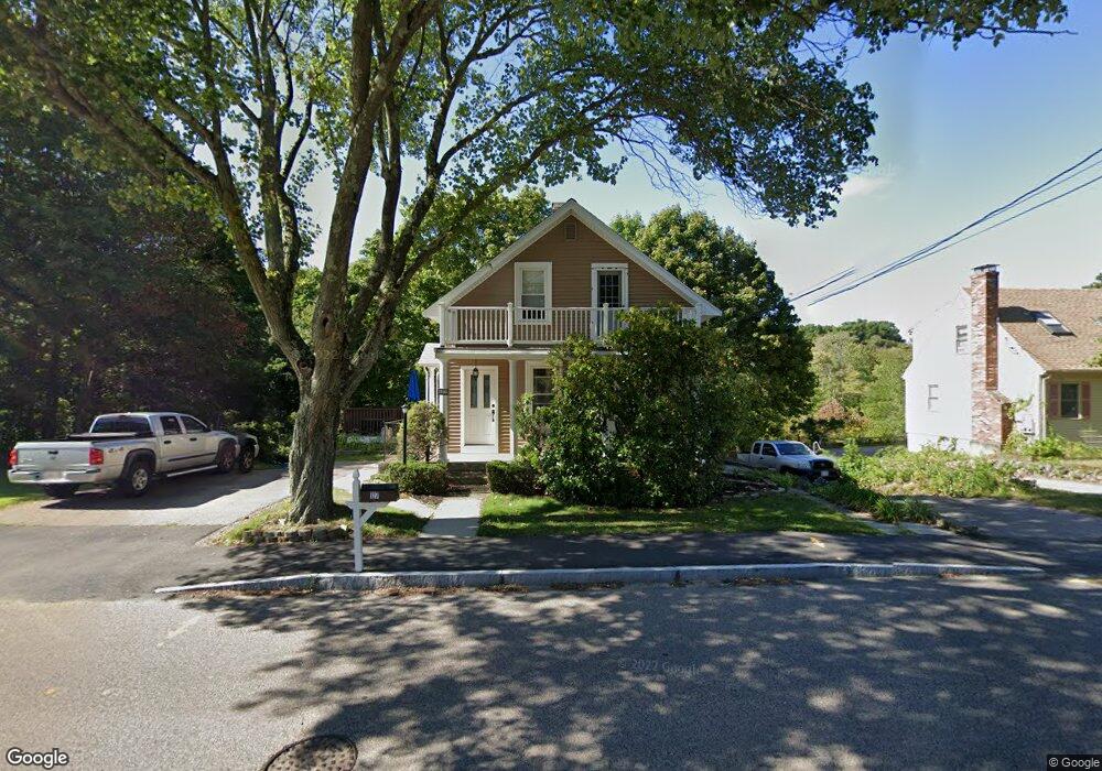
127 Chestnut St Franklin, MA 02038
Downtown Franklin NeighborhoodEstimated Value: $519,000 - $655,000
3
Beds
3
Baths
1,185
Sq Ft
$480/Sq Ft
Est. Value
About This Home
This home is located at 127 Chestnut St, Franklin, MA 02038 and is currently estimated at $569,161, approximately $480 per square foot. 127 Chestnut St is a home located in Norfolk County with nearby schools including Helen Keller Elementary School, Annie Sullivan Middle School, and Franklin High School.
Ownership History
Date
Name
Owned For
Owner Type
Purchase Details
Closed on
Dec 13, 2016
Sold by
Callahan Michael B and Callahan Kathleen M
Bought by
Callahan Rt
Current Estimated Value
Purchase Details
Closed on
May 10, 1990
Sold by
Yankee Tr Gloria
Bought by
Callahan Michael B
Create a Home Valuation Report for This Property
The Home Valuation Report is an in-depth analysis detailing your home's value as well as a comparison with similar homes in the area
Home Values in the Area
Average Home Value in this Area
Purchase History
| Date | Buyer | Sale Price | Title Company |
|---|---|---|---|
| Callahan Rt | -- | -- | |
| Callahan Michael B | $110,000 | -- |
Source: Public Records
Mortgage History
| Date | Status | Borrower | Loan Amount |
|---|---|---|---|
| Previous Owner | Callahan Michael B | $15,000 | |
| Previous Owner | Callahan Michael B | $25,000 | |
| Previous Owner | Callahan Michael B | $50,000 |
Source: Public Records
Tax History Compared to Growth
Tax History
| Year | Tax Paid | Tax Assessment Tax Assessment Total Assessment is a certain percentage of the fair market value that is determined by local assessors to be the total taxable value of land and additions on the property. | Land | Improvement |
|---|---|---|---|---|
| 2025 | $5,665 | $487,500 | $245,200 | $242,300 |
| 2024 | $5,122 | $434,400 | $245,200 | $189,200 |
| 2023 | $5,276 | $419,400 | $247,300 | $172,100 |
| 2022 | $5,007 | $356,400 | $204,400 | $152,000 |
| 2021 | $4,994 | $340,900 | $218,900 | $122,000 |
| 2020 | $4,888 | $336,900 | $220,800 | $116,100 |
| 2019 | $4,637 | $316,300 | $200,100 | $116,200 |
| 2018 | $4,539 | $309,800 | $205,300 | $104,500 |
| 2017 | $4,269 | $292,800 | $188,300 | $104,500 |
| 2016 | $4,043 | $278,800 | $185,200 | $93,600 |
| 2015 | $4,071 | $274,300 | $180,700 | $93,600 |
| 2014 | $3,527 | $244,100 | $151,800 | $92,300 |
Source: Public Records
Map
Nearby Homes
- 67 Milliken Ave Unit 22
- 1 Uncas Ave
- 159 E Central St
- 64 Uncas Ave
- 70 Uncas Ave
- 40 Cross St
- 90 E Central St Unit 103
- 90 E Central St Unit 106
- 90 E Central St Unit 304
- 90 E Central St Unit 202
- 90 E Central St Unit 105
- 90 E Central St Unit 301
- 82 Uncas Ave Unit 1
- 76 Dean Ave
- 99 Summer St
- 32 Dale St
- 266 Pleasant St
- 150 Pleasant St
- 67 Cottage St
- 324 Pleasant St
- 123 Chestnut St
- 117 Chestnut St
- 122 Chestnut St
- 119 Chestnut St
- 97 Chestnut St
- 300 Glen Meadow Rd
- 300 Glen Meadow Rd
- 95 Chestnut St
- 95 Chestnut St Unit A
- 91 Chestnut St
- 136 Chestnut St
- 85 Chestnut St
- 6 Longobardi Dr
- 8 Longobardi Dr
- 4 Longobardi Dr
- 10 Longobardi Dr
- 76 Chestnut St
- 2 Longobardi Dr
- 185 Chestnut St
- 12 Longobardi Dr