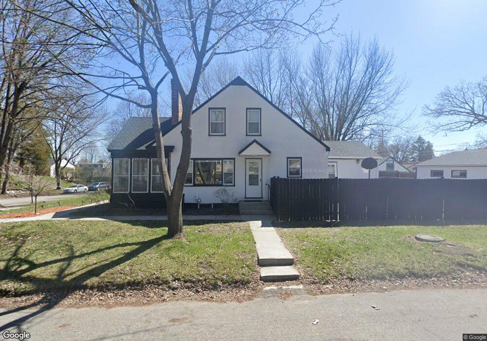
1271 Avon St N Saint Paul, MN 55117
Como Park NeighborhoodEstimated Value: $377,000 - $502,000
4
Beds
2
Baths
1,278
Sq Ft
$339/Sq Ft
Est. Value
About This Home
This home is located at 1271 Avon St N, Saint Paul, MN 55117 and is currently estimated at $432,608, approximately $338 per square foot. 1271 Avon St N is a home located in Ramsey County with nearby schools including Como Park Elementary School, Murray Middle School, and Como Park Senior High School.
Ownership History
Date
Name
Owned For
Owner Type
Purchase Details
Closed on
Jan 2, 2013
Sold by
Adams Joseph M and Adams Katherine Mary
Bought by
Adams Joseph M and Adams Katherine Mary
Current Estimated Value
Home Financials for this Owner
Home Financials are based on the most recent Mortgage that was taken out on this home.
Original Mortgage
$232,962
Outstanding Balance
$163,860
Interest Rate
3.62%
Mortgage Type
FHA
Estimated Equity
$268,748
Create a Home Valuation Report for This Property
The Home Valuation Report is an in-depth analysis detailing your home's value as well as a comparison with similar homes in the area
Home Values in the Area
Average Home Value in this Area
Purchase History
| Date | Buyer | Sale Price | Title Company |
|---|---|---|---|
| Adams Joseph M | -- | None Available |
Source: Public Records
Mortgage History
| Date | Status | Borrower | Loan Amount |
|---|---|---|---|
| Open | Adams Joseph M | $232,962 |
Source: Public Records
Tax History Compared to Growth
Tax History
| Year | Tax Paid | Tax Assessment Tax Assessment Total Assessment is a certain percentage of the fair market value that is determined by local assessors to be the total taxable value of land and additions on the property. | Land | Improvement |
|---|---|---|---|---|
| 2025 | $4,952 | $347,500 | $60,000 | $287,500 |
| 2023 | $4,952 | $324,900 | $60,000 | $264,900 |
| 2022 | $4,456 | $308,300 | $60,000 | $248,300 |
| 2021 | $4,430 | $283,800 | $60,000 | $223,800 |
| 2020 | $4,354 | $291,800 | $60,000 | $231,800 |
| 2019 | $4,138 | $269,000 | $55,000 | $214,000 |
| 2018 | $3,784 | $253,900 | $55,000 | $198,900 |
| 2017 | $3,468 | $241,000 | $46,400 | $194,600 |
| 2016 | $3,794 | $0 | $0 | $0 |
| 2015 | $3,828 | $241,400 | $46,400 | $195,000 |
| 2014 | $3,728 | $0 | $0 | $0 |
Source: Public Records
Map
Nearby Homes
- 1222 Como Blvd E
- 1005 Como Blvd E
- 766 Maryland Ave W
- 1241 Maywood St
- 1084 Ryde St
- 1342 Dale St N
- 1038 Colne St
- 740 Como Ave
- 1083 Chatsworth St N
- 1464 Maywood St
- 705 Como Ave
- 1063 Dale St N
- 989 Barrett St
- 1174 Lexington Pkwy N
- 895 Front Ave
- tbd MacKubin St
- 933 Front Ave
- 1049 Kent St
- 1539 Dale St N
- 1165 Norton St
- 1267 Avon St N
- 1263 Avon St N
- 1277 Avon St N
- 1259 Avon St N
- 1259 1259 Avon-Street-n
- 1260 Victoria St N
- 1281 Avon St N
- 1254 Victoria St N
- 1248 Victoria St N
- 1272 Avon St N
- 817 Orange Ave W
- 1268 Avon St N
- 1262 Avon St N
- 1242 Victoria St N
- 1278 Avon St N
- 1272 Victoria St N
- 1249 Avon St N
- 1258 1258 Avon-Street-n
- 1284 Avon St N
- 1258 Avon St N