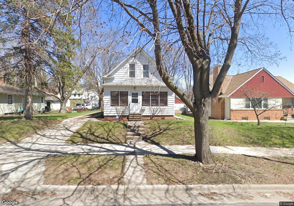
1276 Danforth St Saint Paul, MN 55117
North End NeighborhoodEstimated Value: $290,721 - $390,000
2
Beds
1
Bath
1,293
Sq Ft
$249/Sq Ft
Est. Value
About This Home
This home is located at 1276 Danforth St, Saint Paul, MN 55117 and is currently estimated at $321,430, approximately $248 per square foot. 1276 Danforth St is a home located in Ramsey County with nearby schools including Como Park Elementary School, Murray Middle School, and Como Park Senior High School.
Ownership History
Date
Name
Owned For
Owner Type
Purchase Details
Closed on
Apr 29, 1999
Sold by
Tuft Debra L
Bought by
Stein Kimberly J
Current Estimated Value
Purchase Details
Closed on
Feb 12, 1996
Sold by
Mancuso Patrick
Bought by
Mancuso Patrick J and Mancuso Diane M
Purchase Details
Closed on
Sep 28, 1995
Sold by
Edstrom David P and Edstrom Victoria L
Bought by
Tuft Debra L
Create a Home Valuation Report for This Property
The Home Valuation Report is an in-depth analysis detailing your home's value as well as a comparison with similar homes in the area
Home Values in the Area
Average Home Value in this Area
Purchase History
| Date | Buyer | Sale Price | Title Company |
|---|---|---|---|
| Stein Kimberly J | $106,900 | -- | |
| Mancuso Patrick J | $81,400 | -- | |
| Tuft Debra L | $81,400 | -- | |
| Edstrom David | $25,484 | -- |
Source: Public Records
Mortgage History
| Date | Status | Borrower | Loan Amount |
|---|---|---|---|
| Closed | Edstrom David | -- | |
| Closed | Tuft Debra L | $64,000 | |
| Closed | Mancuso Patrick J | $17,400 |
Source: Public Records
Tax History
| Year | Tax Paid | Tax Assessment Tax Assessment Total Assessment is a certain percentage of the fair market value that is determined by local assessors to be the total taxable value of land and additions on the property. | Land | Improvement |
|---|---|---|---|---|
| 2025 | $4,122 | $290,600 | $50,000 | $240,600 |
| 2023 | $4,122 | $273,900 | $50,000 | $223,900 |
| 2022 | $3,414 | $250,300 | $50,000 | $200,300 |
| 2021 | $3,760 | $223,300 | $50,000 | $173,300 |
| 2020 | $3,590 | $251,500 | $42,500 | $209,000 |
| 2019 | $3,492 | $226,400 | $42,500 | $183,900 |
| 2018 | $3,242 | $218,300 | $42,500 | $175,800 |
| 2017 | $2,956 | $210,200 | $42,500 | $167,700 |
| 2016 | $3,076 | $0 | $0 | $0 |
| 2015 | $2,870 | $201,100 | $42,500 | $158,600 |
| 2014 | $2,862 | $0 | $0 | $0 |
Source: Public Records
Map
Nearby Homes
- 1300 Schletti St
- 585 Cottage Ave W
- 1187 Dale St N
- 1406 Schletti St
- 1104 MacKubin St
- 1070 Dale St N
- 1049 Kent St
- 1048 Dale St N
- 1248 Farrington St
- 307 Maryland Ave W
- 1151 Farrington St
- 1585 Cohansey St Unit 104
- 1120 Virginia St
- 1041 Western Ave N
- 593 Front Ave
- 1215 Galtier St
- 352 Como Ave
- 1547 Virginia St
- 1489 Matilda St
- 1071 Matilda St
- 1284 Danforth St
- 1272 Danforth St
- 1264 Danforth St
- 1277 Kent St
- 1283 Kent St
- 1294 Danforth St
- 1287 Kent St
- 1287 1287 Kent-Street-
- 1271 Kent St
- 595 Orange Ave W
- 1283 Danforth St
- 1291 Kent St
- 1289 Danforth St
- 569 Orange Ave W
- 1300 Danforth St
- 1291 1291 Kent-Street-
- 1295 Danforth St
- 1295 Kent St
- 601 Orange Ave W
- 1260 Danforth St
Your Personal Tour Guide
Ask me questions while you tour the home.