
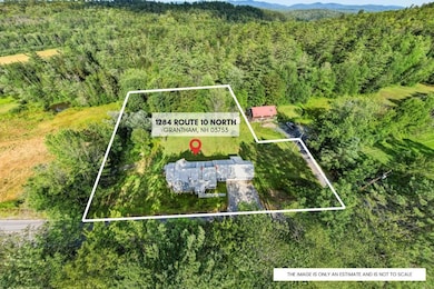
1284 Route 10 N Grantham, NH 03753
Estimated payment $1,770/month
Highlights
- Very Popular Property
- Cape Cod Architecture
- 2 Car Direct Access Garage
- Grantham Village School Rated A
- Wood Flooring
- Fireplace
About This Home
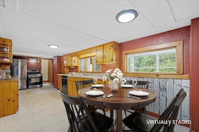
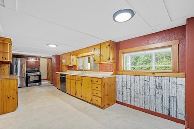
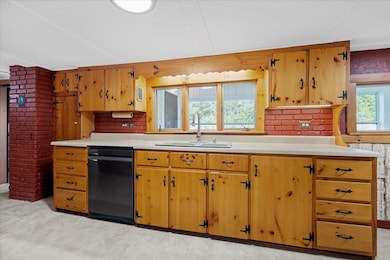
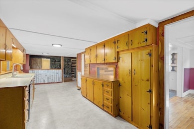
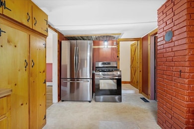
OPPORTUNITY KNOCKING, SELLERS SAYS SELL! CASH BUYERS ONLY. Step into the charm of yesteryear with this beautifully preserved 1850 home - perfect for those who appreciate the unique character, warmth, and craftsmanship of older houses. Thoughtfully designed with both comfort and functionality in mind, the home features three bedrooms plus a dedicated office (or potential fourth bedroom), a formal living room, and a cozy family room accented by a pellet stove and a striking stone fireplace. The dedicated dining room provides an inviting space for gatherings, while the eat-in kitchen offers stainless steel appliances, a gas stove, and plenty of room for everyday living. A first-floor bathroom and laundry area create the possibility for a first-floor bedroom, an option previously used by the sellers - making this layout ideal for multigenerational living or added flexibility. Soft pine flooring runs throughout the home, lending warmth and cohesion to every space. Outside, the large, flat backyard offers a peaceful escape, while the enclosed porch—running the full length of the house—allows you to enjoy the view in comfort, free from bugs or unpredictable weather. Additional highlights include a durable metal roof, excellent insulation, a two-car garage with overhead storage, and a partial house generator for peace of mind. Nestled near scenic hiking trails, this timeless home seamlessly blends historic charm with modern-day practicality. Property is being sold as-is.
Listing Agent
Keller Williams Realty-Metropolitan License #074803 Listed on: 07/29/2025

Home Details
Home Type
- Single Family
Est. Annual Taxes
- $5,430
Year Built
- Built in 1850
Lot Details
- 1.4 Acre Lot
- Property fronts a private road
Parking
- 2 Car Direct Access Garage
- Parking Storage or Cabinetry
- Automatic Garage Door Opener
Home Design
- Cape Cod Architecture
- Concrete Foundation
- Stone Foundation
- Wood Frame Construction
- Metal Roof
Interior Spaces
- Property has 2 Levels
- Woodwork
- Ceiling Fan
- Fireplace
- Combination Kitchen and Dining Room
- Basement
- Interior Basement Entry
- Fire and Smoke Detector
Kitchen
- Gas Range
- Dishwasher
Flooring
- Wood
- Vinyl
Bedrooms and Bathrooms
- 3 Bedrooms
- 2 Full Bathrooms
Laundry
- Dryer
- Washer
Utilities
- Private Water Source
- Dug Well
- Cable TV Available
Listing and Financial Details
- Tax Lot 28
- Assessor Parcel Number 216
Map
Home Values in the Area
Average Home Value in this Area
Tax History
| Year | Tax Paid | Tax Assessment Tax Assessment Total Assessment is a certain percentage of the fair market value that is determined by local assessors to be the total taxable value of land and additions on the property. | Land | Improvement |
|---|---|---|---|---|
| 2024 | $5,430 | $276,900 | $59,900 | $217,000 |
| 2023 | $4,871 | $276,900 | $59,900 | $217,000 |
| 2022 | $4,552 | $276,900 | $59,900 | $217,000 |
| 2021 | $3,993 | $174,200 | $45,900 | $128,300 |
| 2020 | $4,087 | $174,200 | $45,900 | $128,300 |
| 2019 | $4,541 | $175,600 | $36,400 | $139,200 |
| 2018 | $4,581 | $175,600 | $36,400 | $139,200 |
| 2017 | $4,165 | $175,600 | $36,400 | $139,200 |
| 2016 | $4,186 | $175,600 | $36,400 | $139,200 |
| 2015 | $4,235 | $175,600 | $36,400 | $139,200 |
| 2014 | $4,648 | $208,700 | $80,500 | $128,200 |
| 2013 | $4,475 | $208,700 | $80,500 | $128,200 |
Property History
| Date | Event | Price | List to Sale | Price per Sq Ft |
|---|---|---|---|---|
| 11/13/2025 11/13/25 | Price Changed | $250,000 | -23.1% | $156 / Sq Ft |
| 11/03/2025 11/03/25 | Price Changed | $325,000 | -11.0% | $203 / Sq Ft |
| 10/22/2025 10/22/25 | Price Changed | $365,000 | -2.7% | $228 / Sq Ft |
| 10/13/2025 10/13/25 | Price Changed | $375,000 | -3.8% | $234 / Sq Ft |
| 08/25/2025 08/25/25 | Price Changed | $390,000 | -2.5% | $243 / Sq Ft |
| 07/29/2025 07/29/25 | For Sale | $400,000 | -- | $250 / Sq Ft |
Purchase History
| Date | Type | Sale Price | Title Company |
|---|---|---|---|
| Quit Claim Deed | -- | None Available | |
| Warranty Deed | $75,000 | -- |
Mortgage History
| Date | Status | Loan Amount | Loan Type |
|---|---|---|---|
| Previous Owner | $60,000 | Purchase Money Mortgage |
Source: PrimeMLS
MLS Number: 5053969
APN: GRNT-000216-000000-000028
Disclaimer: Certain information contained herein is derived from information provided by parties other than Homes.com. All information provided is deemed reliable, but is not guaranteed to be accurate and should be independently verified.
![]() Copyright 2025 PrimeMLS, Inc. All rights reserved. This information is deemed reliable, but not guaranteed. The data relating to real estate displayed on this display comes in part from the IDX Program of PrimeMLS. The information being provided is for consumers’ personal, non-commercial use and may not be used for any purpose other than to identify prospective properties consumers may be interested in purchasing.
Copyright 2025 PrimeMLS, Inc. All rights reserved. This information is deemed reliable, but not guaranteed. The data relating to real estate displayed on this display comes in part from the IDX Program of PrimeMLS. The information being provided is for consumers’ personal, non-commercial use and may not be used for any purpose other than to identify prospective properties consumers may be interested in purchasing.
- 00 Route 10 N
- 8 Old Spring Dr
- 23 High Pond Rd
- 637 Marmot Ln Unit 37
- 351 Miller Pond Rd
- 6 Anderson Pond Rd
- 64 High Pond Rd
- 3 Water View
- 295 Frye Ln
- 49 Old Beach Cir
- 38 Terrace View
- 442 Olde Farms Rd
- 21 Shore Rd
- 303 Road Round the Rd
- 12 Cherry Ln
- 8 Sandy Brae
- 729 Olde Farm Rd
- 3 Trillium Ln
- 16 Summit Dr
- 45 Bright Slope Way
- 27 Bay Tree Ln Unit A27
- 548 Route 10 N Unit B
- 3 Lark Place
- 4 Morning Hollow Ln
- 24 Bright Slope Way
- 9 Pioneer Point
- 4 Pioneer Point
- 14 Pioneer Point
- 112 Greensward Dr
- 11 Sugarwood Ln
- 10 Merrill Place Unit 161
- 7 Wells St
- 7 Wells St
- 335 Us-4 Unit A
- 41 N Shore Rd
- 25 Mountain View Dr
- 96 Fairway Dr
- 6 Paquette Ln
- 43 Piney Point Rd
- 34 Fairway Dr Unit 34