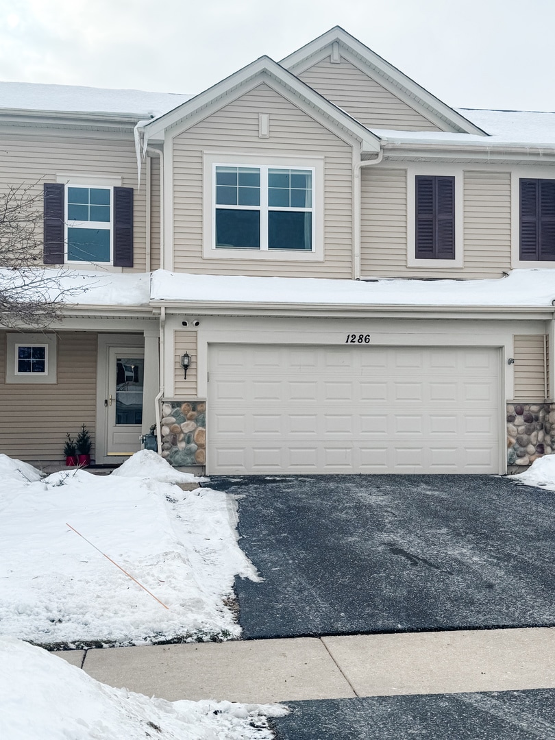
1286 Newport Cir Pingree Grove, IL 60140
Estimated payment $2,429/month
Highlights
- Very Popular Property
- Loft
- Built-In Features
- Hampshire High School Rated A-
- Stainless Steel Appliances
- Walk-In Closet
About This Home
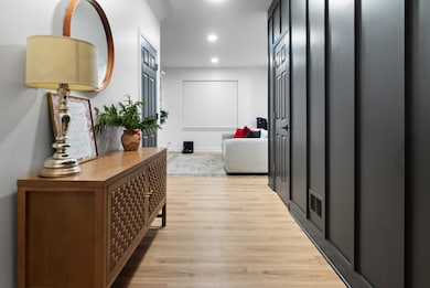
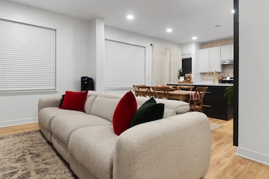
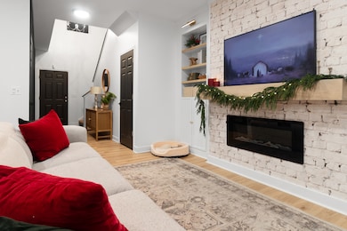
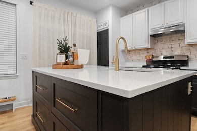
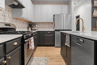
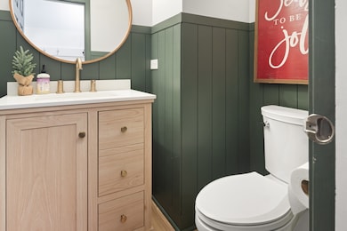
Step into a dream come true-the best townhome in Cambridge Lakes. This professionally decorated 2-bedroom, 2.5-bath home has been fully transformed with extraordinary upgrades. There is nothing cookie cutter here. The interior features custom shelving, smart storage solutions, and upgraded kitchen, all designed to increase functionality and comfort. The home has been professionally decorated, giving each room a polished, cohesive look without being overdone. Both bedrooms are well-sized, each with its own beautifully finished bathroom, and the main living spaces offer an easy, comfortable flow. Have I mentioned storage? There are tons of storage cabinets through the home. The loft can be used as a game room, play room or easily converted into a third bedroom. Located in a highly regarded school district, the property sits within a well-maintained association that includes a community room and attractive common areas. It's clear that this home has been cared for and improved with long-term value in mind. If you're looking for a move-in-ready townhome with standout upgrades and a warm, modern feel, this is the best options available on the market today.

Townhouse Details
Home Type
- Townhome
Est. Annual Taxes
- $5,871
Year Built
- Built in 2011
Lot Details
- Lot Dimensions are 60 x 30
HOA Fees
Parking
- 2 Car Garage
- Driveway
- Parking Included in Price
Home Design
- Entry on the 1st floor
- Asphalt Roof
- Stone Siding
Interior Spaces
- 1,545 Sq Ft Home
- 2-Story Property
- Built-In Features
- Bookcases
- Living Room
- Dining Room
- Open Floorplan
- Loft
- Carpet
Kitchen
- Range
- Microwave
- Dishwasher
- Stainless Steel Appliances
- ENERGY STAR Qualified Appliances
- Disposal
Bedrooms and Bathrooms
- 2 Bedrooms
- 2 Potential Bedrooms
- Walk-In Closet
- Dual Sinks
- Separate Shower
Laundry
- Laundry Room
- Dryer
- Washer
Schools
- Gary Wright Elementary School
- Hampshire Middle School
- Hampshire High School
Utilities
- Forced Air Heating and Cooling System
- Heating System Uses Natural Gas
- 100 Amp Service
- Lake Michigan Water
Listing and Financial Details
- Homeowner Tax Exemptions
Community Details
Overview
- Association fees include insurance, clubhouse, exercise facilities, pool, exterior maintenance, lawn care, snow removal, lake rights
- Agen Association
- Property managed by Foster Premier
Pet Policy
- Dogs and Cats Allowed
Map
Home Values in the Area
Average Home Value in this Area
Tax History
| Year | Tax Paid | Tax Assessment Tax Assessment Total Assessment is a certain percentage of the fair market value that is determined by local assessors to be the total taxable value of land and additions on the property. | Land | Improvement |
|---|---|---|---|---|
| 2024 | $5,871 | $79,192 | $14,428 | $64,764 |
| 2023 | $5,703 | $71,616 | $13,048 | $58,568 |
| 2022 | $5,036 | $58,519 | $12,030 | $46,489 |
| 2021 | $4,899 | $55,041 | $11,315 | $43,726 |
| 2020 | $4,813 | $53,636 | $11,026 | $42,610 |
| 2019 | $4,711 | $51,479 | $10,583 | $40,896 |
| 2018 | $4,427 | $46,399 | $9,932 | $36,467 |
| 2017 | $4,328 | $44,185 | $9,458 | $34,727 |
| 2016 | $4,300 | $42,065 | $9,004 | $33,061 |
| 2015 | -- | $39,729 | $8,504 | $31,225 |
| 2014 | -- | $38,991 | $8,504 | $30,487 |
| 2013 | -- | $40,666 | $8,660 | $32,006 |
Property History
| Date | Event | Price | List to Sale | Price per Sq Ft |
|---|---|---|---|---|
| 12/12/2025 12/12/25 | For Sale | $315,000 | -- | $204 / Sq Ft |
Purchase History
| Date | Type | Sale Price | Title Company |
|---|---|---|---|
| Warranty Deed | $148,000 | First American Title |
Mortgage History
| Date | Status | Loan Amount | Loan Type |
|---|---|---|---|
| Open | $144,155 | FHA |
Source: Midwest Real Estate Data (MRED)
MLS Number: 12531851
APN: 02-29-403-023
Disclaimer: Certain information contained herein is derived from information provided by parties other than Homes.com. All information provided is deemed reliable, but is not guaranteed to be accurate and should be independently verified.
![]() Based on information submitted to the MLS GRID. All data is obtained from various sources and may not have been verified by broker or MLS GRID. Supplied Open House Information is subject to change without notice. All information should be independently reviewed and verified for accuracy. Properties may or may not be listed by the office/agent presenting the information. Some IDX listings have been excluded from this website.
Based on information submitted to the MLS GRID. All data is obtained from various sources and may not have been verified by broker or MLS GRID. Supplied Open House Information is subject to change without notice. All information should be independently reviewed and verified for accuracy. Properties may or may not be listed by the office/agent presenting the information. Some IDX listings have been excluded from this website.
The Digital Millennium Copyright Act of 1998, 17 U.S.C. § 512 (the “DMCA”) provides recourse for copyright owners who believe that material appearing on the Internet infringes their rights under U.S. copyright law. If you believe in good faith that any content or material made available in connection with our website or services infringes your copyright, you (or your agent) may send us a notice requesting that the content or material be removed, or access to it blocked.
Notices must be sent in writing by email to DMCAnotice@MLSGrid.com.
The DMCA requires that your notice of alleged copyright infringement include the following information:
(1) description of the copyrighted work that is the subject of claimed infringement;
(2) description of the alleged infringing content and information sufficient to permit us to locate the content;
(3) contact information for you, including your address, telephone number and email address;
(4) a statement by you that you have a good faith belief that the content in the manner complained of is not authorized by the copyright owner, or its agent, or by the operation of any law;
(5) a statement by you, signed under penalty of perjury, that the information in the notification is accurate and that you have the authority to enforce the copyrights that are claimed to be infringed; and
(6) a physical or electronic signature of the copyright owner or a person authorized to act on the copyright owner’s behalf. Failure to include all of the above information may result in the delay of the processing of your complaint.
- 1385 Broadland Dr
- 1157 Clearwater Dr
- 1641 Sandcastle Ln
- 1701 Windward Dr
- 1308 Bayberry Cir
- 1192 Alta Vista Dr
- 1740 Spinnaker St
- 1482 Hollow Tree Ln
- 1731 Dempsey Cir
- 1840 Spinnaker St
- 955 Emerald Dr
- 932 Clover Ln
- 1929 Diamond Head Trail
- 898 Emerald Dr
- 888 Galway Ln
- Lot 019 Old Stage Rd
- 562 Lancaster Dr
- 975 Valley Stream Dr
- 700 Brighton Dr
- 2307 Upland Rd
- 1092 Sapphire Ln
- 1735 Bayberry Ln
- 924 Clover Ln Unit 1
- 818 Glen Cove Ln
- 545 Yorkshire Ln
- 2307 Upland Rd
- 1555 Sequoia Way
- 2463 Bella Dr
- 2480 Bella Dr
- 672 Anchorage Ct
- 45W005 Berner Rd Unit A
- 2552 Cesario Dr
- 573 Telluride Dr
- 573 Telluride Dr Unit 6254
- 895 Brielle Blvd
- 133 Willey St Unit 2755
- 346 Evergreen Cir Unit 346
- 440 E Jefferson Ave Unit 3
- 208 Goldenrod Dr Unit 1
- 434 Town Center Blvd