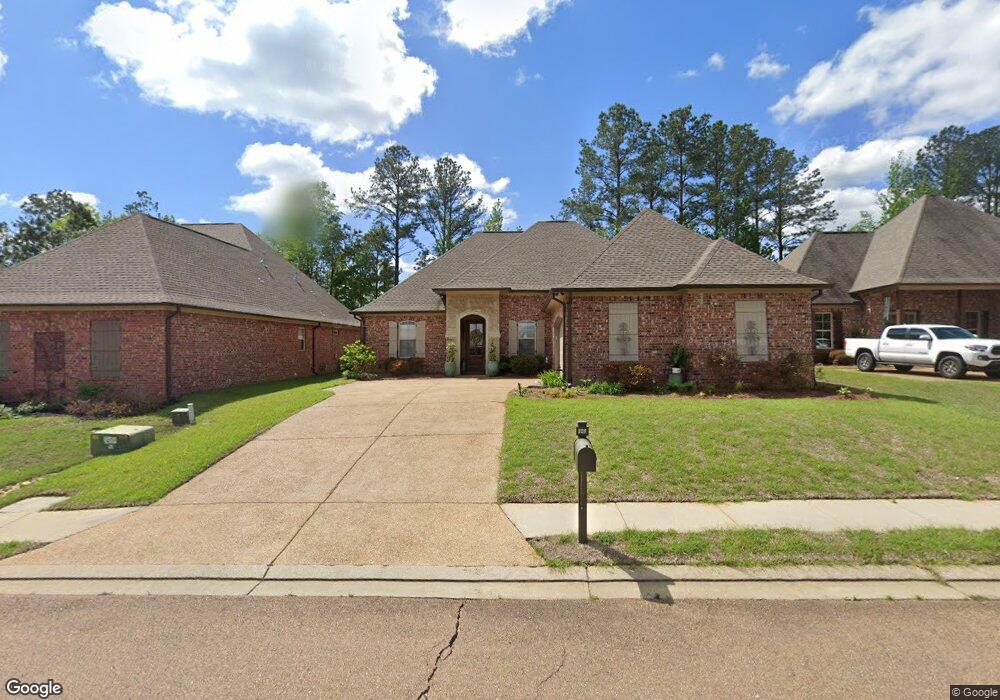
129 St Croix Ln Madison, MS 39110
Estimated Value: $381,000 - $565,000
3
Beds
20
Baths
1,999
Sq Ft
$222/Sq Ft
Est. Value
About This Home
This home is located at 129 St Croix Ln, Madison, MS 39110 and is currently estimated at $443,793, approximately $222 per square foot. 129 St Croix Ln is a home located in Madison County with nearby schools including Canton High School.
Ownership History
Date
Name
Owned For
Owner Type
Purchase Details
Closed on
Dec 14, 2012
Sold by
Patrick Rowland Builders Llc
Bought by
Westbrook Ethel Moore
Current Estimated Value
Home Financials for this Owner
Home Financials are based on the most recent Mortgage that was taken out on this home.
Original Mortgage
$234,693
Outstanding Balance
$162,101
Interest Rate
3.38%
Mortgage Type
New Conventional
Estimated Equity
$281,693
Purchase Details
Closed on
Sep 12, 2011
Sold by
Caroline Twenty Two Llc
Bought by
Patrick Rowland Builders Llc
Create a Home Valuation Report for This Property
The Home Valuation Report is an in-depth analysis detailing your home's value as well as a comparison with similar homes in the area
Purchase History
| Date | Buyer | Sale Price | Title Company |
|---|---|---|---|
| Westbrook Ethel Moore | -- | None Available | |
| Patrick Rowland Builders Llc | -- | First Guaranty Title Inc |
Source: Public Records
Mortgage History
| Date | Status | Borrower | Loan Amount |
|---|---|---|---|
| Open | Westbrook Ethel Moore | $234,693 |
Source: Public Records
Tax History
| Year | Tax Paid | Tax Assessment Tax Assessment Total Assessment is a certain percentage of the fair market value that is determined by local assessors to be the total taxable value of land and additions on the property. | Land | Improvement |
|---|---|---|---|---|
| 2025 | $1,499 | $21,654 | $0 | $0 |
| 2024 | $1,499 | $21,654 | $0 | $0 |
| 2023 | $1,977 | $21,654 | $0 | $0 |
| 2022 | $1,977 | $21,654 | $0 | $0 |
| 2021 | $1,707 | $20,793 | $0 | $0 |
| 2020 | $1,870 | $20,793 | $0 | $0 |
| 2019 | $1,870 | $20,793 | $0 | $0 |
| 2018 | $1,870 | $20,793 | $0 | $0 |
| 2017 | $1,835 | $20,454 | $0 | $0 |
| 2016 | $1,802 | $20,454 | $0 | $0 |
| 2015 | $1,720 | $20,454 | $0 | $0 |
| 2014 | $1,592 | $20,454 | $0 | $0 |
Source: Public Records
Map
Nearby Homes
- 0 Harbor View Dr Unit 4143375
- 0 Harbor View Dr Unit 4137745
- 124 Saint Croix Ln
- 102 Saint Martin St
- 102 Heron's Bay Cir
- 108 Martinique Dr
- 155 Harbor View Dr
- 116 Springs Crossing
- 121 Harbor View Dr
- 192 Harbor View Dr
- 209 Harbor View Dr
- Lot A2 164 Lake Ridge Dr
- 106 Herons Bay Cir
- 214 Herons Bay Cir
- 220 Herons Bay Cir
- 104 Herons Bay Cir
- 103 Seymour Dr
- 0 Coyote Cove
- 104 Talbot Ct
- 124 Lake Crest Dr
- 131 St Croix Ln
- 127 St Croix Ln
- 117 St Croix Ln
- 125 St Croix Ln
- 133 St Croix Ln
- 128 St Croix Ln
- 123 St Croix Ln
- 123 Saint Croix Ln
- 129 Herons Bay Cir
- 135 St Croix Ln
- 135 Saint Croix Ln
- 127 Herons Bay Cir
- 121 Saint Croix Ln
- 141 Martinique Dr
- 0 Harbor View Dr Unit 53 311361
- 0 Harbor View Dr Unit 63 1341653
- 0 Harbor View Dr Unit 8 1336395
- 0 Harbor View Dr Unit 53 1314819
- 0 Harbor View Dr Unit 53 1311361
- 0 Harbor View Dr Unit 4031026
Your Personal Tour Guide
Ask me questions while you tour the home.