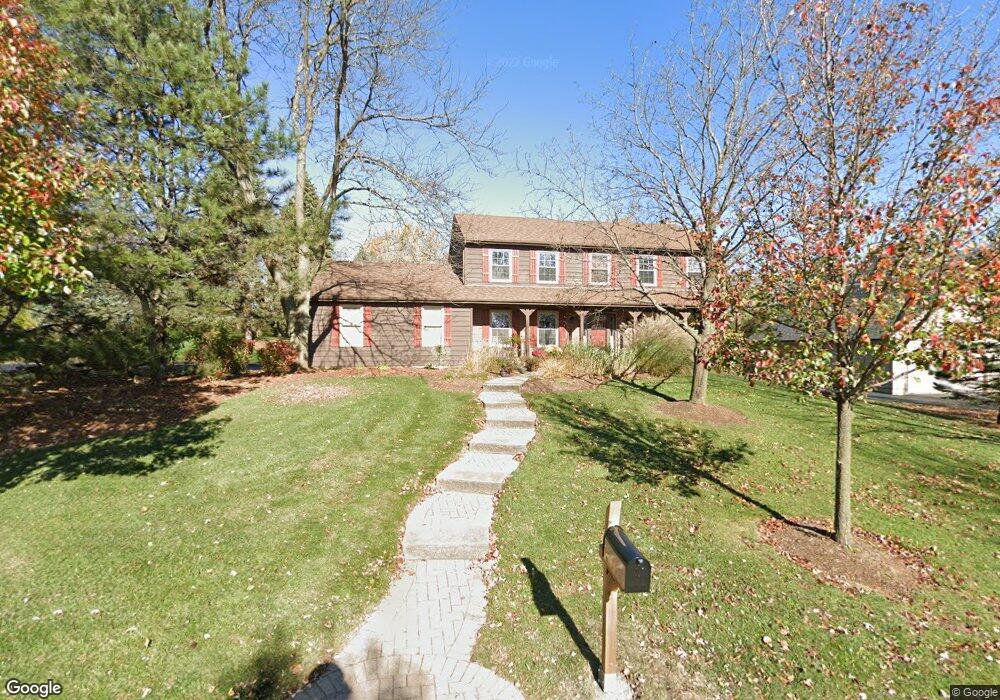
1340 Gaslight Dr Algonquin, IL 60102
Estimated Value: $457,185 - $476,000
4
Beds
3
Baths
2,352
Sq Ft
$200/Sq Ft
Est. Value
About This Home
This home is located at 1340 Gaslight Dr, Algonquin, IL 60102 and is currently estimated at $470,046, approximately $199 per square foot. 1340 Gaslight Dr is a home located in Kane County with nearby schools including Westfield Community School, Kenneth E Neubert Elementary School, and Harry D Jacobs High School.
Ownership History
Date
Name
Owned For
Owner Type
Purchase Details
Closed on
Apr 28, 2004
Sold by
Auvenshine Jimmy Don
Bought by
Sigrist Nick L and Sigrist Linda M
Current Estimated Value
Home Financials for this Owner
Home Financials are based on the most recent Mortgage that was taken out on this home.
Original Mortgage
$180,000
Outstanding Balance
$82,599
Interest Rate
5.63%
Mortgage Type
Purchase Money Mortgage
Estimated Equity
$387,447
Create a Home Valuation Report for This Property
The Home Valuation Report is an in-depth analysis detailing your home's value as well as a comparison with similar homes in the area
Purchase History
We collect this data history from publicly available records. To have your information removed, we recommend requesting removal directly through your county’s website.
| Date | Buyer | Sale Price | Title Company |
|---|---|---|---|
| Sigrist Nick L | $295,000 | Burnet Title Llc |
Source: Public Records
Mortgage History
We collect this data history from publicly available records. To have your information removed, we recommend requesting removal directly through your county’s website.
| Date | Status | Borrower | Loan Amount |
|---|---|---|---|
| Open | Sigrist Nick L | $180,000 |
Source: Public Records
Tax History
| Year | Tax Paid | Tax Assessment Tax Assessment Total Assessment is a certain percentage of the fair market value that is determined by local assessors to be the total taxable value of land and additions on the property. | Land | Improvement |
|---|---|---|---|---|
| 2024 | $8,360 | $125,951 | $25,939 | $100,012 |
| 2023 | $7,921 | $113,326 | $23,339 | $89,987 |
| 2022 | $7,868 | $105,144 | $23,339 | $81,805 |
| 2021 | $8,043 | $99,277 | $22,037 | $77,240 |
| 2020 | $7,887 | $97,045 | $21,542 | $75,503 |
| 2019 | $8,200 | $98,359 | $20,450 | $77,909 |
| 2018 | $8,074 | $93,571 | $26,182 | $67,389 |
| 2017 | $7,751 | $87,531 | $24,492 | $63,039 |
| 2016 | $7,951 | $84,751 | $23,714 | $61,037 |
| 2015 | -- | $79,415 | $22,221 | $57,194 |
| 2014 | -- | $73,790 | $21,607 | $52,183 |
| 2013 | -- | $76,048 | $22,268 | $53,780 |
Source: Public Records
Map
Nearby Homes
- 1335 Gaslight Dr
- 14 Hampton Ct
- 1210 Merrill Ave
- SWC Talaga and Algonquin Rd
- 1421 Notting Hill Rd
- 1713 Edgewood Dr
- 655 Oakview Dr
- 635 Oakview Dr Unit 6
- 1721 Waverly Ln
- Lot #3-5 Hayes Rd
- 209 Beach Dr
- 660 Juniper Cir
- 1530 Westbourne Pkwy
- 1540 Westbourne Pkwy
- 731 Roaring Brook Ln
- 811 Westbury Dr
- 2067 Peach Tree Ln Unit 4115
- 2117 Peach Tree Ln Unit 4084
- 761 Majestic Dr
- 2161 Burnham Ct
- 12084 Kingston Place
- 12014 Kingston Place
- 1330 Gaslight Dr
- 1320 Gaslight Dr
- 1310 Gaslight Dr
- 11985 Devonshire St
- 11955 Devonshire St
- 1400 Gaslight Dr
- 1300 Gaslight Dr
- 11923 Devonshire St
- 1410 Gaslight Dr
- 1220 Gaslight Dr
- 12079 Kingston Place
- 1325 Gaslight Dr Unit 2
- 1345 Gaslight Dr
- 1315 Gaslight Dr Unit 2
- 1405 Gaslight Dr
- 11910 Kingston Place
- 1420 Gaslight Dr
- 1305 Gaslight Dr
Your Personal Tour Guide
Ask me questions while you tour the home.