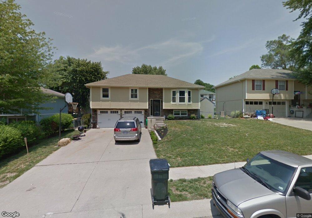
137 Debra St Lansing, KS 66043
Estimated Value: $257,000 - $281,562
4
Beds
3
Baths
1,227
Sq Ft
$222/Sq Ft
Est. Value
About This Home
This home is located at 137 Debra St, Lansing, KS 66043 and is currently estimated at $272,641, approximately $222 per square foot. 137 Debra St is a home located in Leavenworth County with nearby schools including Lansing Elementary School, Lansing Middle 6-8, and Lansing High 9-12.
Ownership History
Date
Name
Owned For
Owner Type
Purchase Details
Closed on
Dec 14, 2017
Sold by
Butler Julie S and Butler Tyrone K
Bought by
Mccullum Daneen O
Current Estimated Value
Home Financials for this Owner
Home Financials are based on the most recent Mortgage that was taken out on this home.
Original Mortgage
$150,505
Outstanding Balance
$126,712
Interest Rate
3.94%
Mortgage Type
New Conventional
Estimated Equity
$145,929
Create a Home Valuation Report for This Property
The Home Valuation Report is an in-depth analysis detailing your home's value as well as a comparison with similar homes in the area
Home Values in the Area
Average Home Value in this Area
Purchase History
| Date | Buyer | Sale Price | Title Company |
|---|---|---|---|
| Mccullum Daneen O | $188,131 | Mccaffree-Short Title Co Inc |
Source: Public Records
Mortgage History
| Date | Status | Borrower | Loan Amount |
|---|---|---|---|
| Open | Mccullum Daneen O | $150,505 |
Source: Public Records
Tax History Compared to Growth
Tax History
| Year | Tax Paid | Tax Assessment Tax Assessment Total Assessment is a certain percentage of the fair market value that is determined by local assessors to be the total taxable value of land and additions on the property. | Land | Improvement |
|---|---|---|---|---|
| 2025 | $3,952 | $30,822 | $4,342 | $26,480 |
| 2024 | $3,681 | $29,636 | $3,399 | $26,237 |
| 2023 | $3,681 | $28,497 | $3,399 | $25,098 |
| 2022 | $3,414 | $25,013 | $2,805 | $22,208 |
| 2021 | $3,042 | $21,220 | $2,805 | $18,415 |
| 2020 | $2,747 | $18,883 | $3,214 | $15,669 |
| 2019 | $2,591 | $17,803 | $3,214 | $14,589 |
| 2018 | $2,491 | $17,135 | $3,214 | $13,921 |
| 2017 | $2,127 | $14,646 | $3,214 | $11,432 |
| 2016 | $2,107 | $14,502 | $2,804 | $11,698 |
| 2015 | $2,069 | $14,290 | $2,804 | $11,486 |
| 2014 | $2,152 | $15,157 | $2,691 | $12,466 |
Source: Public Records
Map
Nearby Homes
- 1100 N 4th St
- 1102 N 4th St
- 1102 N Main St
- 4 Eisenhower Rd
- 603 E Beth St
- 601 E Eisenhower Rd
- 268 Holiday Dr
- 129 Brookwood St
- 415 Fairlane St
- 129 Crestview Ct
- 218 Oak Hill St
- 20958 Ida St
- 310 E Kansas Ave
- 610 Meadowlark Rd
- 542 Creekside Ct
- 124 S Main St
- 202 S Main St
- 218 E Kay St
- 306 E Kay St
- 728 Eisenhower Rd